Distance
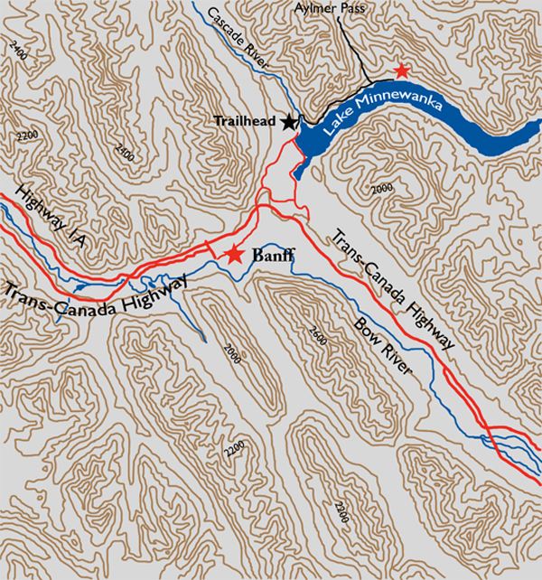
Day tripping from campground LM 8 includes either exploring the trail farther up the lake or the 800-m upward climb to Aylmer Lookout.

The trail is evident, but keep an eye out for the official Parks Canada name of Campground LM 8, not Aylmer Pass Campground. Some 30–35 minutes into the hike the path begins its climb, soon reaching its apex at 1562 m, N51 15 22.6 W115 28 48.1. Looking to the north (left) at a magnificent bluff with many great slabs eroded away, it is soon understood why the trail is a trek on loose rubble. In due course the elevation is lost as once more the trail drops down close to the lake.
After an hour and a half of hiking, you enter an exposed aspen and birch grove with a hillside on the left that is devoid of trees. This simply adds to the overall appeal of this trip. Five minutes later the deciduous stand merges back into conifers and the path crosses a small river. The rest of the hike is a walk of a little over a kilometre, skirting the lake through forest to the campground.
Aylmer lookout is the best day trip from the campground, and begins as a 2.3-km hike with an elevation gain of almost 600 m. This is a steep grade and not for the faint of heart. At 2.3 km a sign will guide you to the right for another 1.7-km hike to the Aylmer Lookout, built in 1946 as one of seven fire lookouts in Banff National Park. If you still have some energy, go back to the junction, turn right and climb upward for another 3.4 km to reach the crest of Aylmer Pass, at 2287 m. This a total elevation gain of nearly 800 m in 5.6 km. An amazing workout.
History
In 1888 the original name of either Devil’s Head Lake or Devil’s Lake was replaced by the Department of the Interior to the more tourist friendly one of Minnewanka. “Minnewanka,” translated from the Stoney, means “Lake of the water spirit.” The original moniker came by way of a Stoney legend of a half-man, half-fish creature that inhabited the lake, victimizing innocent boaters.
Many years before, in 1841, Sir George Simpson called the lake “Peechee” after his Métis guide, whose name was actually spelled “Piché.” However, the name was never official and did not appear on any maps or documents. During a cross-continent trip in 1884, Dr. G.M. Dawson named a peak at the south end of the lake Mount Peechee in honour of the same Métis guide, though Piché himself was not on this trip with Dawson.
Mount Aylmer was named by J.J. McArthur in 1890 to immortalize his hometown of Aylmer, Quebec, which in turn was named for Matthew Whitworth-Aylmer, Fifth Baron Aylmer (1775–1850), who served as both Governor General of British North America and Lieutenant Governor of Lower Canada from 1831 to 1835.
During the late 1800s and early 1900s the northwest end of Lake Minnewanka was a resort community called Minnewanka Landing. It was situated near the present-day tourist area, and consisted of hotels, wharves, cottage lots and cottages and restaurants. Boat tours and sailing excursions were also offered. As a popular resort community in close proximity to Banff townsite, the place needed an improved shoreline to spruce up its appeal, so a wooden dam was constructed on Devil’s Creek, which accomplished this goal at least for awhile.
In 1912, a second dam was built, this time in Devil’s Canyon, for the purpose of water storage, thus creating another new shoreline by raising the lake level by 3.5 m. The consequence of this action was the flooding of Devil’s Creek. This was not enough for poor Lake Minnewanka, though, as the federal government constructed a power plant in 1923 to supply electricity to Banff, and finally, in 1941, the present-day dam was built under the War Measures Act. The final dam raised the water level by an astounding 30 m, extending the lake an additional 8 km in length and flooding the entire town of Minnewanka Landing.
Today the submerged remains of the town are used for recreational scuba diving, with Parks Canada supplying detailed maps, buoys, markers and interpretations of the entire town and the various bridges and dams.
Directions
Park in the spacious Lake Minnewanka parking lot, 5.5 km north of the intersection of the Trans-Canada Highway and Lake Minnewanka Road, at the east gate to the Banff townsite. Walk the pavement past the concession stand on the left and a covered picnic area farther up the trail on the right. Pick up the sign with the graphic of the hiker on it directing you to the trailhead.