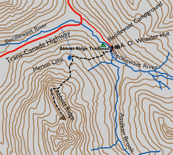
Distance

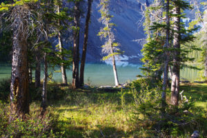
The trailhead sign discloses that it is 4.9 km to the ridge. Other than relentless switchbacks through a stunning green forest, there really is not much to describe. The path is well worn, but the forest is not, as views through the thick growth are sporadic at best. An hour of clambering uphill approaches a fork in the trail, and a pleasant little lake, Marion, is a nice surprise for a break. At 1707 m high, the route has gained 481 m of the 1106 m required to summit. A quick diversion along the right-hand fork leads to a viewpoint overlooking the entrance to Connaught Tunnel. Close inspection and patience will reveal train traffic entering and exiting the tunnel.
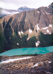
Continue into the forest and climb again, until the path leaves the trees and opens to a boulder patch and a magnificent alpine meadow. Now the hike is well worth the effort. The grind of uphill trekking always pays dividends; otherwise we would not put ourselves through it. The scenery is stunning and the pleasure of strutting through the alpine is exhilarating, yet calming.
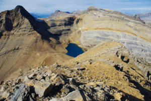
Watch closely for a sign saying shortcUt and go that way. Eventually the trail passes by the Abbott Observatory, which is used to measure snowpack and other weather phenomena in the area. The route carries on past the observatory, winding up to the summit ridge. The ridge is extensive and becomes narrower as it progresses, so get in touch with your comfort zone before going beyond it. We came across a couple of worn resting areas with small cairns where scramblers had gone as far as they felt happy with.
Mount Bonney and its glacier are visible 5 km to the southwest, while the Hermit Range is unmistakable directly north. The amazing Sir Donald Range commands the eastern horizon.
Abbott history
This magnificent ridge, as well as Mount Abbott, Abbott Creek, Abbott Lake (in the Cariboo region), Abbott Peak, Abbott Street (in Vancouver) and the city of Abbotsford, BC, were all named after Harry Braithwaite Abbott. From 1884 to 1886, Abbott was superintendent of the CPR’s western division, just two years after entering the service of the railway as a protégé of William Van Horne himself. From 1886 to 1897, during the early formation of Glacier House, Abbott was superintendent of the Pacific division.
Abbott was born in Abbotsford, Quebec, in 1829 and subsequently attended Montreal High School, followed by a further education at McGill College. After graduation, he applied his education as a civil engineer with a variety of railways, including the St. Lawrence & Atlantic, the Carillon & Grenville, the Brockville & Ottawa, the Eastern Extension, the Baltimore & Ohio and the Canada Central, finally making a long-lasting career with the CPR.
Abbott was stationed in Vancouver and resided there for most of his career, subsequently having the village of Abbotsford named in his honour, although one of the “t’s” was dropped when the village was named by its owner, Charles Maclure. In 1909, Abbott purchased the Farr and Marpole ranches. The previous owner of the Marpole, Dalton P. Marpole, perished in a barn fire on this property in 1908. Dalton was the son of Richard Marpole, who would eventually assume Abbott’s position as general superintendent of the Pacific division of the CPR. Abbott renamed the Farr and Marpole properties “Quincharden Ranch,” and although he did not live at the ranch, he spent substantial time there. Abbott’s son, Harry Hamilton Abbott, and his wife, Elizabeth, managed the ranch in his absence.
Abbott’s brother, Sir John Abbott, was Prime Minister of Canada for 17 months following the death of Sir John A. Macdonald in 1891.
Mount Abbott, in the nearby vicinity of Abbott Ridge, received its name in 1886, and it is assumed the ridge was given its name around the same time. The ridge was not traversed until much later, by Alexander A. McCoubrey and his party in 1911. McCoubrey had moved to Canada from Scotland in 1900 at the age of 15, and four years later he was employed with the CPR in Manitoba. He was involved with initiating the sport of backcountry skiing in Manitoba and was instrumental in the formation of the Alpine Club of Canada (ACC) in 1906. His busy, inquisitive lifestyle encouraged him to take on responsibilities with the ACC as president from 1932 to 1934 and as both editor of the Canadian Alpine Journal and chairman of the Manitoba section of the ACC from 1931 to 1941. Most of McCoubrey’s climbing and exploring took place in the breathtaking beauty of the Purcell Mountains, and he was responsible for many first ascents, including the Leaning Towers.
Directions
The trailhead is located in Illecillewaet Campground’s recreation area, 3 km west of the crest of Rogers Pass. This minor exit off the highway is a busy little mecca for campers, hikers, scramblers, climbers, cross-country skiers and picnickers. Enter the campground off the east side of the Trans-Canada Highway, drive past the day-use area and park near the small welcome centre. It is here that you purchase passes for camping or day hiking. The well-marked trailhead is just beyond the welcome centre, and in fact all of the hikes in this vicinity are identified by an abundance of bulletin boards, maps and markers. After buying a day pass, continue along the main road, and when it turns to gravel, follow the right fork to the remains of Glacier House.

Gerry Shea
“Gerry Shea moved to Kamloops from Vancouver at the age of nine, which is when he became enchanted by the nearby hills. It was on a family vacation many years later that he discovered the mountains and began hiking and climbing in his spare time, gathering knowledge and experience that he has since used to help beginning hikers, scramblers and backpackers to trek safely. Gerry lives in Kamloops with his wife and children.”Excerpt From: Gerry Shea. “The Aspiring Hiker’s Guide 2: Mountain Treks in British Columbia.” iBooks.