Distance
Akamina Ridge is my favourite ridgewalk. It is a long moderate day hike via the peaceful shores of Wall Lake and up through wildflower meadows beside cascading waterfalls to a wide, shale-covered and undulating alpine ridge.
At one place on the ridge you can almost reach the three-way boundaries between BC, Alberta and Montana. Not only political borders straddle this impressive divide. The headwaters of three major North American rivers all diverge from this mountainous region. The Columbia, Saskatchewan and Mississippi rivers all start here at the “Crown of the Continent,” and each one flows into a different ocean. The name Crown of the Continent is commonly used when describing the area protected in the Waterton/Glacier National Park in Alberta, Glacier National Park in Montana and the Akamina–Kishinena Provincial Park in BC.
Fierce winds often scour this high-country prominence. Walking sticks blew out sideways, tea flew out of our Thermos cups, and walking in the wind was a challenge. It’s worth it, though.
Wall Lake to Akamina Ridge – return the same way
This route is more scenic, easier and safer than the alternative listed below. The best part is the ridgewalk. It’s a long, full-day trek: 25.6 km from the trailhead to Forum Peak on the ridge and back to the trailhead (22.6 km from the Akamina campsite).
I do not recommend this route, but some people do. The route makes Akamina Ridge a loop hike, but in my opinion this route to the same place as described above is not worth it, for scenery and for difficulty.
BC Parks describes an unmaintained and unsigned wilderness route there. The suggested route has hikers climbing a very steep, exposed scramble up the ridge west of Forum Lake to Akamina Ridge. Once on Akamina Ridge, hike west to Bennett Pass and down to Wall Lake.
We tried climbing up that way from Forum Lake a couple of years ago and it was very steep, not marked, exposed and too scary. I would much rather hike a lot longer distance and have a nice scenic trip. The longer hiking distance also doesn’t take any longer in time, as it’s easier going the whole way.
Unless you are skilled at steep exposed scrambling, DO NOT HIKE DOWN the rock ridge west of Forum Lake. It is better to hike up the steep, loose and rocky section than it is trying to come down it.
Rating: moderate
Time: full day hike
Distance: 12.8 km to Forum Peak
Elevation change: 670 m (2,200 ft.)
Highest summit: 2560 m (8,400 ft.)
Forum Peak: 2470 m (8,100 ft.)
Trail: good trails signed to Wall Lake are easy to follow to Bennett Pass; open scenic ridgewalk
Map: 82G/1 Sage Creek (NAD83)
Trail map
Drive
Road: any vehicle; all pavement
See road directions to Cameron Lake Road or Akamina Pass campground in the Akamina-Kishinena Provincial Park section earlier in this chapter.
Wall Lake to Akamina Ridge – return the same way
0 km: From the trailhead on Cameron Lake Road in Waterton Lakes National Park.
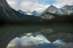
5.0 km: Wall Lake (see entry #44). Follow the signed trail to Bennett Pass, gaining 518 m (1,700 ft.). The trail climbs out from Wall Lake and into the forest, then edges out of the forest onto a huge avalanche slope, with wildflowers, beargrass and an alpine creek spreading through an alpine meadow. It is very scenic, with the cliff wall rising high above the navy-blue Wall Lake.
7.3 km: At Bennett Pass, 2300 m (7,600 ft.), turn left (southeast) and follow the wide-open ridge. The highest summit is an unnamed peak at 2560 m (8,500 ft.). Walk as far along the ridge as your energy permits. The entire ridge is 5 km long from Bennett Pass to Forum Peak. From Bennett Pass, the ridge ascends 180 m (600 ft) to its highest summit, 2560 m (8,400 ft.). From there, descend and ascend a few times as you hike along the undulations of the alpine ridge to Forum Peak.
12.8 km: Forum Peak, 2470 m (8,100 ft.), overlooking Cameron Lake in Alberta, is the eastern edge of the Akamina Ridge.
25.6 km: Return to the trailhead the same way you climbed up to it. Backtrack along the ridge to Bennett Pass, down to Wall Lake and down the easy hike to the trailhead.
Do not hike down from the ridge to Forum Lake. It is exposed, dangerous scrambling. Instead, take my suggested gentler route, backtracking along the ridge to Wall Lake.
Forum Lake to Akamina Ridge
Rating: moderate with difficult scrambling section
Distance: loop 18.3 km
Elevation gain: 670 m (2,200 ft.)
Trail
0 km: Trailhead on Cameron Lake Road in Waterton National Park. Hike to Forum Lake, gaining 335 m (1,100 ft.). See entry #69 for Forum Lake.
3.5 km: Forum Lake. Routefind up on the right side (west) heading up to the ridge. Gain another 335 m (1,100 ft.) very steeply in 1.5 km. This is steep exposed scrambling with loose rock and variable hand- and footholds. It is considered a wilderness route and no defined trails have been established.
5 km: Akamina Ridge. To look down onto Cameron Lake, hike left (east) on the ridge 1 km to Forum Peak.
6 km: Forum Peak. Backtrack along the ridge and continue west for 5 km.
11 km: Bennett Pass. Turn right and hike the trail downhill southeast to Wall Lake.
13.3 km: Wall Lake. Follow the signed trail to the campsite and the trailhead.
18.3 km: Back to the trailhead.
Directions
Road: any vehicle; all pavement
See road directions to Cameron Lake Road or Akamina Pass campground in the Akamina-Kishinena Provincial Park

Janice Strong
Janice Strong is an established professional outdoor photographer. Her images grace collections all over the world and appear in many respected publications. She is passionate about hiking and is also an avid snowshoer and skier, exploring the outdoors of the East Kootenay in southeastern BC year round.She openly shares her passion for the outdoors with others and has introduced hundreds of people to the joys of hiking. For a decade she led hikes for the City of Cranbrook – Parks and Recreation. With her guidance, many people have themselves become enthusiastic hikers.
Climbing mountains, finding new places and enjoying the experience of the journey have always been important to Janice. She cherishes the little things she sees along the trail, as well as the grand destinations.
When Janice is not writing, hiking or taking photographs, she is involved in various creative digital, website design or photographic projects for her clients. She and her husband, Jamie Levine, enjoy their rural property, near Cranbrook, BC.


