Distance
A long day trip from this campsite will take you to the historic remains of the Old Tie Camp, which in the 1910s was used by the Otto brothers for making railway ties. Remnants of the camp include lumber from boats, cabins and the mill and scrap metal from cans and tools.

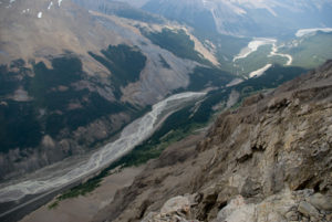
Although the campground is not extraordinary, the scenery certainly is. A range of mountain peaks separating the Whirlpool River and Geraldine Lakes lying in the next valley to the southeast occupies the horizon directly across the river. At this site the Whirlpool River widens, creating eddies, stillness and even marshes at low water.
The day trip on this excursion is an additional 8 km of easy hiking from Whirlpool Campground. The fire road continues for 2 km until it reaches a single-track tributary trail off to the right into the bush. Continuing straight on the fire road ends within 25–30 m, leaving no doubt that the preferred route is into the forest. The remaining 6 km is a path which opens periodically to offer the occasional panorama. The trail makes its way past Tie Campground at the 11.3-km mark. This should not be confused with the historic Old Tie Camp, which is 2.2 km farther up the trail.
History
Athabasca Pass was discovered by David Thompson in 1811 after the Peigan Indians prohibited travel through Howse Pass in 1810. The Peigan had become particularly hostile toward white men after their defeat by Native enemies who had been equipped with firearms supplied by white traders. With Howse Pass closed by the Peigan to thwart further trade, Thompson’s new pass became the main fur trade route over the Rockies.
Thompson set out on October 29, 1810, leaving Boggy Hall with the largest contingent of manpower in his renowned career. The party consisted of three women, 25 men and 24 horses. Among the party was William Henry, as clerk, and an Iroquois guide known as Thomas, who would direct the group over the pass. Henry would eventually leave the expedition and set up a supply line from a post on the Athabasca River.
After months of gruelling challenges, horrible weather, frustrated companions and impossible terrain, they arrived at the northernmost point of the Big Bend of the Columbia River on January 19, 1811. By now all but five men had left the team. Two stayed with Thompson to construct a building to wait out the winter while three more returned for supplies. On February 17 the three men returned to “Boat Encampment,” the name given by Thompson and his men to the winter settlement, to spend the next two months constructing a canoe.
Traders using the pass departed the North Saskatchewan River and travelled cross county to the Athabasca River. After passing Jasper House, the pass ventured up the Whirlpool River. From the summit the trail made its way to the Canoe River by way of the Wood River and finally to the Big Bend of the Columbia.
Although the pass was difficult to cross (it was declared as “not fit for horses”) and was out of the way because it was so far north, it was all that was available at the time. There were rumours of Kootenay Indian crossings, though these were not confirmed until many years later. So it was that Athabasca Pass became the main route for almost 50 years.
Directions
From the intersection of Highway 16 and the Icefields Parkway (Highway 93) drive south for 30 km until you reach the Athabasca Falls turnoff on the right side of the highway. This in turn will place you on Highway 93A. Stay on this roadway for 8.6 km, going past the Athabasca Falls parking lot turnoff on the left, to the Moab Lake intersection. Turn left. The remainder of the drive is now on a very dusty gravel road lasting 7.0 km, though the posted distance reads 7.5 km. The Moab Lake parking lot is the trailhead for this adventure.