Distance
Above the lake there is a summit to climb. The unnamed peak rises from the northwest side of the lake to 2391 m (7,846 ft.).
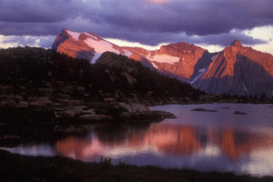
Colourful talus tumbles into the western lakeshore, in shades of ochre and brown and some with hints of purple. These rocks are similar to the rocks found in the Wigwam Flats area and in Akamina Kishinena Provincial Park.
Enjoy the lake and the scenic hike through the rolling terrain of the southern Rockies.
If the trail is snow-covered
The trail across the plateau bends around in several directions. When snow obscures the trail the terrain is confusing, as the plateau slopes east and Baldy Lake is reached by heading northwest. Keep heading parallel to the obvious ridge just west of the plateau. You may find faded orange triangles nailed to trees, which may lead you across the flat ground of the plateau for about 2 km. You also could take a compass bearing from the first notch, which is the narrow pass you reach after the initial climb. Take the bearing straight across the plateau to the visible second notch, or use GPS guidance.
Maintained by the Kootenay Backcountry Horsemen
0 km: Leaving the road, the trail climbs through the forest, switching back many times for the first 1.5 km. This steep section takes about 30 minutes and heads generally north, gaining about 274 m (900 ft.).
1.8 km: The path bends around to the west (left) and slides through a notch, a short gully with gently sloping sides, N31800-E50800, 2040 m (6,700 ft.). From the end of this gully, look northwest to another notch, 2 km across the sparsely treed rolling meadows of the plateau. Head toward the second notch on the well-made trail.
4.1 km: Reach a narrow gully and it’s the second notch, N33071-E49370. Don’t descend the narrow gully; instead look left for a trail marker on a tree. The trail makes a sharp left turn and heads uphill into the forest. The trail climbs again to the lake.
5.5 km: Baldy Lake, N33600-E48400, at 2080 m (6,838 ft.).
Ridgewalk
For an alternative route on the hike out, follow the forest section of trail until you reach the plateau. There you may want to climb the grassy ridge west of the trail and hike the short ridgewalk back to the first notch. The ridge is 210 m (700 ft.) higher than the plateau and is only 2 km long. Good views of Lake Koocanusa and Tobacco Plains area.
Baldy Lake Map
Akamina-Kishinena Provincial Park Adjacent to national parks of Waterton in Alberta and Glacier in Montana
Akamina-Kishinena Provincial Park
Akamina-Kishinena Provincial Park (AK), in the southeastern corner of BC, is wedged between Waterton Lakes National Park in Alberta and Glacier National Park in Montana. Today the combined protected areas are becoming well-known as “The Crown of the Continent.”
The headwaters of three major North American rivers all diverge from this mountainous region. The Columbia, Saskatchewan and the Mississippi rivers all start in “The Crown of the Continent” and each flows into different oceans.
Hiking
Old Akamina Road (non-motorized access only) is the primary access for hikers or cyclists into AK park. The road begins from the paved Cameron Lake Road in Waterton Lakes National Park in Alberta. It climbs 130 m (450 ft.) in 1.2 km and crosses the BC/Alberta border over the low Akamina Pass, 1800 m (5,900 ft.). The road was first built in the 1920s along Akamina and Kishinena creeks and connects with the BC Flathead River valley.
The Akamina Ridge hike is the nicest ridge walk I know of. The ridge is wide and expansive and alpine plants cover its rocky terrain. The ridge drops off on the northern side, plunging in a cliff into three lakes: Wall and Forum lakes in BC and Cameron Lake in Alberta.
Camping in Akamina-Kishinena Park
Camping in the park is limited to one site, at Akamina Pass near the ranger station. It is 1.5 km to 2 km from the trailhead on Cameron Lake Road. Staying at the campsite shortens the hike to Akamina Ridge. The tent sites, outhouse and food slings are all beside Akamina Road, a busy cyclist and hiker route. BC Parks charges a fee per person per night. The campsite is not scenic, nor is it secure from thieves who may pass by. We have had things stolen. The campsite is in a dark forest of spindly ingrown pine. The water supply is questionable, and I advise filtering all your drinking water. Mosquitoes like the spot, too.
Ecosystems and mountain ridges
The three large parks of Waterton, Glacier and AK collectively not only protect the forest, rock and ice, but their combined scale ensures security of the largest self-sustaining population of grizzly bears on the continent.
The mountain ridges of AK contain some of the oldest exposed rocks in the Rockies. Estimates show these rocks are 1.3 billion years old. Colourful rocks of amber, purple and red are on the Akamina Ridge and the shores of Forum and Wall lakes. The rocks at Forum are reputed to be the oldest.
Waterton Lakes and Glacier national parks were previously united as the world’s first International Peace Park in 1932. The United Nations recognized the partnership of the parks in 1976 as a biosphere reserve. Then UNESCO furthered the area’s reputation in 1995 when it declared the Waterton–Glacier International Peace Park a World Heritage Site. BC granted park status to AK in 1995 (after years of negotiations), thus completing the region’s protected status.
Directions
Road: any vehicle; good gravel FS road
Take Highway 93 to just north of the US border. The Baldy Lake access begins from a small road east of the highway. Turnoff from the highway is 3.7 km north of the Roosville US Customs border station or, if driving south on Highway 93 from Highway 3 (Elko), drive south for 31 km, N32502-E42482.
0 km: From Highway 93, turn east onto a small road signed “Truck Route McDonald Ranch & Lumber.” The road stretches 200 m across a tiny field.
200 m: After this field, turn left uphill and continue another 300 m.
600 m: Turn right at the signed Phillips Creek road intersection and drive uphill, south, on good gravel road.
1.8 km: Stay on main road, left fork (34 km sign) (rerouted around an old washout).
5.4 km: Continue straight (38 km sign).
11.3 km: Look for a narrow hiking trail on the left (north) side going up into the trees (near 43 km sign). Trailhead may or may not be signed. If you reach the summit of Galton Pass at 45 km sign, turn back about 500 m and look for the trail. Wide parking spot is just 100 m past the trailhead, N31041-E51774, at 1820 m (5,980 ft.).

Janice Strong
Janice Strong is an established professional outdoor photographer. Her images grace collections all over the world and appear in many respected publications. She is passionate about hiking and is also an avid snowshoer and skier, exploring the outdoors of the East Kootenay in southeastern BC year round.She openly shares her passion for the outdoors with others and has introduced hundreds of people to the joys of hiking. For a decade she led hikes for the City of Cranbrook – Parks and Recreation. With her guidance, many people have themselves become enthusiastic hikers.
Climbing mountains, finding new places and enjoying the experience of the journey have always been important to Janice. She cherishes the little things she sees along the trail, as well as the grand destinations.
When Janice is not writing, hiking or taking photographs, she is involved in various creative digital, website design or photographic projects for her clients. She and her husband, Jamie Levine, enjoy their rural property, near Cranbrook, BC.


