Distance
The west side of the loop trail is in cooler moist forest on an old road that follows the western slopes of the deep and narrow Lizard Creek valley. This western part of the trail offers good views of the impressive and rugged limestone slopes of the Lizard Range, spanning from northwest to southeast.
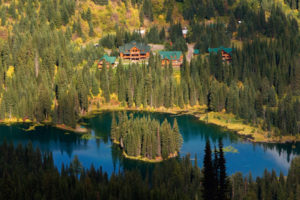
From the ridge and summit, hikers can look down to Island Lake. Mount Fernie and the Three Sisters are part of the panoramic view from Mount Baldy. The trail is well-defined and -signed.
Island Lake Resort trails are on private property. Please respect the trails and the privilege to be allowed to hike on them. For more on Island Lake Resort

0 km: Island Lake Resort visitors’ day-use parking lot. From the lodge, head north and follow signs for Baldy Loop. The trail switchbacks up a hot, south-facing slope of an old burn, gaining almost all of its elevation in 3.2 km.
3.2 km: Summit ridge of Mount Baldy; a road runs along the short ridge with a cairn, 1930 m (6,330 ft.). Follow the road heading uphill to the west (left).
3.6 km: Mount Baldy summit trail takes off from the ridge road to the right (north). The trail is 150 m long to the summit tower and it gains another 30 m (100 ft.). Return back to the main trail on the road and follow it downhill to the southwest.
5.3 km: The road approaches Lizard Pass at the headwaters of Lizard Creek. Follow the signs for Baldy Loop. Leave the old road, and a sign indicates downhill into the mature forest on a trail.
7.9 km: Follow the trail to Fir Trail near the lake and hike back uphill slightly.
8.4 km: Island Lake. Hike uphill back to the resort and parking lot.
Directions
Road: any vehicle; gravel to Island Lake Resort; washboards
Follow directions to Island Lake Resort. Park at the Island Lake Resort visitors’ day-use parking lot.

Janice Strong
Janice Strong is an established professional outdoor photographer. Her images grace collections all over the world and appear in many respected publications. She is passionate about hiking and is also an avid snowshoer and skier, exploring the outdoors of the East Kootenay in southeastern BC year round.She openly shares her passion for the outdoors with others and has introduced hundreds of people to the joys of hiking. For a decade she led hikes for the City of Cranbrook – Parks and Recreation. With her guidance, many people have themselves become enthusiastic hikers.
Climbing mountains, finding new places and enjoying the experience of the journey have always been important to Janice. She cherishes the little things she sees along the trail, as well as the grand destinations.
When Janice is not writing, hiking or taking photographs, she is involved in various creative digital, website design or photographic projects for her clients. She and her husband, Jamie Levine, enjoy their rural property, near Cranbrook, BC.