Distance
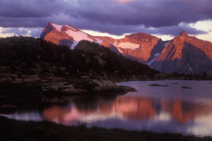
The physical exertion of a mountain hike soon etched a wide smile into our faces. We paused for a moment to enjoy the splendour along the short but steep hike up to Bear Lake. I especially cherish the calm feeling I get when I’m at the lakeshore.
Bear Lake is a 500-m-long lake that is clear, cold and a fabulous blue-green. Large spruce trees cling to the sparse soil along the shore, separated by gently sloping, grassy meadows. It takes about 1 to 1.5 hours of steep climbing on a trail to reach Bear Lake. The path is muddy in the middle section, as a creek trickles down the trail, making it very slippery.
A small campsite with an outhouse is about halfway along the northern lakeshore. Bear Lake is a fine trip for beginners, and the surrounding mountain landscapes make it a great hike for everyone.
Pass above Bear Lake
From Bear Lake, continue east on the trail across alpine meadows. Climb another 213 m (700 ft.) up to the pass in a serrated ridge between Bear Lake and Ruault Lake at 2377 m (7,800 ft.). The defined trail, about 2 km long, climbs steeply and the last incline switchbacks in tight turns with increasing steepness.
Loop trail via Little Bear Tarn
You can make a loop and return to your vehicle via Little Bear. From the pass, scramble up to a small peak just south (right) of the Bear/Ruault Pass. Gain 60 m (200 ft.) and follow the scenic ridge south for about 600 m to Little Bear Pass, N13100-E11000. This little ridgewalk is worth it and scenic, and it is the subject of the back-cover photo of this book.
Beyond Little Bear Pass, a trail heads down in the non-descript forest along the northern slope of Little Bear Tarn, which is a swampy mini-tarn about 100 m wide or less, and through a damp meadow. Little Bear trail intersects with the main Bear Lake trail about 1 km from the parking lot.
Many hikers enjoy a loop trip, but the route from Little Bear Pass is not nearly as nice as the Bear Lake side. I prefer the finer scenery, more flower meadows and the interest of the main Bear Lake trail. So I hike up to the ridgewalk near Little Bear Pass for the view and descend via Bear Lake.
0 km: Hike north uphill. Trail curves right parallel to the creek. The forest is the steepest section.
0.8 km: The grade levels and the main trail veers left away from creek. (Across creek (right) route to swampy Little Bear Tarn.)
1 km: Main trail (left) steepens into an eroding wet gully. A new steep trail (branches right) up to Bear Lake, but misses the scenic white rock slope and views.
1.5 km: If you selected the older left branch, the gully is slippery. Reach scenic limestone talus. Follow well-worn trail up south side of talus. Bear Lake is just over the crest.
2.1 km: Bear Lake, N13900-E09900.
Directions
Road: high-clearance vehicle for final 4.5 km at least
Follow detailed directions for Wild Horse Creek Road.
0 km: Wild Horse Creek Road junction with Wardner/Fort Steele Road.
19.0 km: Small Tackle Creek bridge crossing, at a bush campsite (after 18 km sign).
19.5 km: Wild Horse Creek crossing small bridge.
20 km: Turn right (east) onto a steep uphill side road for Bear Lake, N13479-E06479 (20 km sign). Climb this bumpy dirt side road up a dozen or so switchbacks for about 4.5 km and the road levels out. Waterbars (cross ditches) slash across the road for water drainage.
24.6 km: Parking #1 in a flat clearing by a creek crossing. If the creek looks drivable, continue across, but the road gets rough and rocky for the next 1 km and you may need a 4x4 for traction.
25.6 km: Parking #2 at the end of the road, N13300-E09100.

Janice Strong
Janice Strong is an established professional outdoor photographer. Her images grace collections all over the world and appear in many respected publications. She is passionate about hiking and is also an avid snowshoer and skier, exploring the outdoors of the East Kootenay in southeastern BC year round.She openly shares her passion for the outdoors with others and has introduced hundreds of people to the joys of hiking. For a decade she led hikes for the City of Cranbrook – Parks and Recreation. With her guidance, many people have themselves become enthusiastic hikers.
Climbing mountains, finding new places and enjoying the experience of the journey have always been important to Janice. She cherishes the little things she sees along the trail, as well as the grand destinations.
When Janice is not writing, hiking or taking photographs, she is involved in various creative digital, website design or photographic projects for her clients. She and her husband, Jamie Levine, enjoy their rural property, near Cranbrook, BC.


