Distance
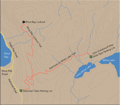
Because of the elaborate array of trails in the Blind Bay/White Lake system, there is an abundance of directional signs. Although the trails are well marked, I have included directions at key junctions simply because signs can get knocked over, and without these indicators it would be difficult to find your way. If all posts are upright, simply follow the markers to White Lake.

A few minutes later, at the next intersection, turn right again. The grade now increases, taking you up a series of lengthy switchbacks for about five minutes.
After the switchbacks, the path levels, the views widen and you encounter another sign. At this point, Giant Tree Loop heads off to the right on an optional diversion that’s all of 81 m long. The main trail continues straight.
After five minutes of level hiking, the path meets another sign, this one directing you to the right. You have now walked 1.25 km.
Another 4–5 minutes of steady hiking brings you to another junction pointing to White Lake to the right.
With 2 km of hiking now behind you, you approach a key crossing. Once again, follow the highly visible markers to cross a multi-use road and resume on the single-track trail on the other side. You have about 6 km remaining to hike before reaching White Lake.
The next 1.5 km consists of a pleasant walk through an exposed mixed forest of trembling aspen and amabilis fir. The trail steepens near the end of this section, and at its zenith you will approach another major crossing. Join this multi-use trail by making a right turn, but almost immediately a minor path leaves the multi-use trail off to the left. This path is appropriately marked with signage. You now have 4.3 km remaining.
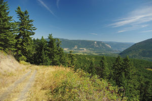
Ten to 15 minutes later, the path reaches its summit exposing a fantastic, unobstructed vista of Little White Lake.
After lingering long enough to soak in this scenery, continue along the trail as it descends to White Lake, about 3.5 km down the trail. The remainder of the journey is easily navigated as the trail criss-crosses the same multi-purpose road several times before arriving at John Evdokimoff Bike Park, approximately 45 minutes later. This bike park is the end of the trail.
Return the same way unless you have arranged to be picked up at the bike park.
Directions
From the Trans-Canada Highway approximately 25 km west of downtown Salmon Arm, turn right onto Balmoral Rd and drive 1.6 km to the Balmoral Trails parking lot.