Distance
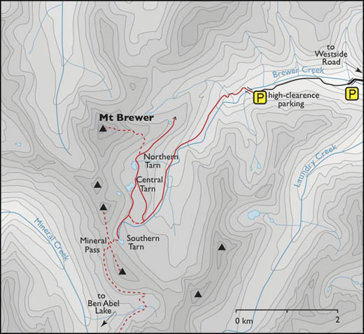
As you gain elevation, you are treated to grand views, the best being from Brewer/Mineral Pass, which spans a wide and gently rolling ridge.
Three large tarns, “Northern,” “Central” and “Southern,” are surrounded by larch trees and add punctuation to this peaceful, charming area of upper Brewer Creek. Northern Tarn is the deepest and largest of these small lakes, each joined by a kilometre of picturesque alpine trail. Central Tarn is deep and scenic. Above Southern Tarn rises Brewer/Mineral Pass.
From the pass, large deep valleys spread out below us in several directions, giving an awe-inspiring perspective to the landscape. We enjoyed finding familiar mountains in the distant landscape: Mount Nelson, Mount Assiniboine and Delphine Glacier.
Basic routefinding experience will help you find your way through the middle basins leading to the upper tarns and the pass. Most of the hike is on a trail, but frequently the trail is indistinct across wet meadows and muddy ground.

0 km: Leave the large parking spot at the end of the road at 1890 m (6,200 ft.) and hike across a new bridge over Brewer Creek to the north side. After 500 m, cross a tiny tributary creek.
600 m: Right fork (uphill) branch in old logging block.
800 m: Second right fork (southwest) and the road becomes a trail. Defined trail gains elevation steadily for 1.2 km. Look for orange diamonds nailed high on trees, as trail markers.
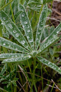
2 km: Following a steep section in the forest, the trail slides out into a meadow. Don’t rest here, because just over 100 m farther is a scenic meadow beside the quickly moving stream with a mountain view, N80636-E56078. The path meanders southwest to the end of the valley through lush moist meadows with many creeks and soft mossy wetlands (riparian area). The water constantly changes the surface of this riparian area, obscuring the trail in some places.
2.9 km: The trail leaves the meadow and heads into partially open subalpine forest laced with several trickling creeks. The route then follows a tributary creek up a narrow gully.
4 km: The trail splits, N79141-E55451. The gully opens into a large damp meadow. Far to the right (northwest) across the meadow is an orange trail marker nailed to a tree. The marker points to a well-built, evenly graded trail. Head uphill on this trail, northwest in the forest, to the Central and Northern tarns, 2300 m (7,600 ft.). (The other split from the meadow is best hiked on the way down. It is an undefined, steeper route and it enters this meadow from the west, down a rocky creek and sparsely treed avalanche area.)
4.8 km: Central Tarn, N79818-E55239.
5.4 km: Keep to the north shore of the tarn and follow a trail for 600 m to reach the largest and deepest of the tarns, Northern Tarn, N79800-E55200. (This trail continues northward, likely connecting with an undeveloped route to Mount Goldie trail from Panorama Ski Resort on Toby Creek. I have yet to follow it, though, as Brewer/Mineral Pass and the southern tarns are the most scenic of this hike and they invite me south, not north.) From Northern Tarn you can either head to the Brewer/Mineral Pass via Mount Brewer or take the meadow trail at the scenic base of the mountain.
Mount Brewer option
Northern Tarn is also the base for the climb up Mount Brewer. The peak rises to a dome-shaped, grassy and rocky summit directly northwest of Northern Tarn. Scramble up 420 m (1,400 ft.) to the summit at 2800 m (9,180 ft.).
Meadow Trail option
I prefer to hike back to the Central Tarn and take the moderate trail south along the base of Mount Brewer and the ridge. Views along this alpine meadow are worth it. Climb south from Central Tarn on a good trail and then the trail stays on contour.
Some 800 m south of Central Tarn, the trail goes by the top of a steep gully, N79170-E55020. This is the route down to where the trail split in the lower meadow. Hike down the left of the gully in the avalanche slope of small trees. But don’t head down yet. Brewer/Mineral Pass and the southern group of tarns still await. Continue south on the trail.
7.4 km: Round a corner to Southern Tarn in an inviting meadow and the sloping ramps of an unnamed summit framing the Purcell Mountain scene, 1.2 km south of Central Tarn.
8.1 km: Hike the well-defined, rocky trail from Southern Tarn up to Brewer/Mineral Pass at 2480 m (8,156 ft.), gaining only 106 m (350 ft.) to the pass, N78707-E54693. Walk along the ridge and enjoy the views in every direction. Mount Brewer rises 2 km north of the pass.
Directions
Road: sturdy 2WD car; narrow, rocky, moderately steep in short sections; high-clearance 4x4 for the rough, rocky, final 2.4 km.
The drive is about one hour on rough gravel roads from Highway 93/95 by Fairmont.
Fairmont access
About 5 km south of Fairmont Hot Springs along Highway 93/95, turn right (north) onto Westside Road, which is just 100 m north of the Dutch Creek hoodoos and Dutch Creek bridge. The hoodoos are steeply eroded, impressive gravel pinnacles that rise straight up for 122 m (400 ft.), alongside the highway.
Follow the paved Westside Road north for 7.4 km and turn west (left) on gravel Hawke Road. There is a large Hoodoos Information sign at the corner.
Invermere access
Drive 2.7 km west from Highway 93/95, heading toward Invermere city centre (Athalmer Highway). At the stoplights in Athalmer, continue straight to the top of the hill (about 400 m). Drive south on 10th Avenue (Invermere’s main street) for another 800 m. Turn right at 13th Street and drive uphill to 13th Avenue and turn south (left). Road becomes scenic, paved Westside Road.
Drive 18 km south from Invermere on Westside Road and turn right (west) onto Hawke Road. Brewer Creek Road starts at the junction of Hawke Road and Westside Road.
Reset odometer to 0.
0 km: Junction of Westside Road and Hawke Road, N79958–E76414. Large sign describing Hoodoos Trails. Drive west on gravel Hawke Road.
8 km: Take the right fork through an old burned area. Brewer Creek BC Forest Service Road traverses private property (8 km sign).
10.7 km: Take the right fork (11 km sign) on Brewer Creek FS Road. Avoid a small road left downhill near this junction.
11.3 km: Take the prominent left fork (avoid Brewer Ridge Road, the right fork). Small roads branch off; stay on the main road.
14.5 km: Take the next major right fork, signed Brewer Creek (before 15 km sign).
25.4 km: Cross Brewer Creek Bridge (24 km sign), N81996-E59555. Immediately after the bridge, take the right fork. You’ll need a high-clearance 4x4 beyond the bridge. The road is rough and rocky for 2.4 km. If the last road bridge is out, add an extra elevation gain of 180 m (600 ft.).
27.8 km: At the end of the road, at 1880 m (6,180 ft.), park in a large parking spot, N81730 –E57524.

Janice Strong
Janice Strong is an established professional outdoor photographer. Her images grace collections all over the world and appear in many respected publications. She is passionate about hiking and is also an avid snowshoer and skier, exploring the outdoors of the East Kootenay in southeastern BC year round.She openly shares her passion for the outdoors with others and has introduced hundreds of people to the joys of hiking. For a decade she led hikes for the City of Cranbrook – Parks and Recreation. With her guidance, many people have themselves become enthusiastic hikers.
Climbing mountains, finding new places and enjoying the experience of the journey have always been important to Janice. She cherishes the little things she sees along the trail, as well as the grand destinations.
When Janice is not writing, hiking or taking photographs, she is involved in various creative digital, website design or photographic projects for her clients. She and her husband, Jamie Levine, enjoy their rural property, near Cranbrook, BC.