Distance
The pass is often still snow covered until mid-July and in some years may again be under new snow by mid-September. Very few trees grow at these high elevations because of the short summer season.
An old mining road climbs up to the pass from Bugaboo Creek, giving the ascent a moderate grade with views south to Quintet Peaks, with their unnamed glacier, and to Phacelia Pass. (Silky phacelia is a common purple wildflower on the dry rocky slopes of this region.)
The Quintet Peaks stand over 2740 m (9,000 ft.) and they appear as black pointed cones on the south side of the pass as you hike up. In contrast, the mountains just north of the pass rise in rounded grey summits over 2430 m (8,000 ft.), offering a neutral background for the wildflowers.
Bugaboo Pass is a good hike to add to the other day hikes in the Bugaboo area, as it completes the region’s impressive viewscape.

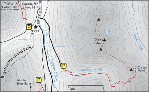
0 km: Park at the end of the road, 1580 m (5,200 ft.). Follow the trail west into the forest.
300 m: Two logs spanning the large, fast-moving creek form a “bridge.” Dogs and children may have a problem with this crossing. Follow a fairly new section of trail that climbs steeply, with the creek far below you on the left. It intersects with an old mining road/trail that is partially overgrown with alders. The trail alternates between rough-hewn bits of well-defined trail up into the thick forest and the old mining road.
1.9 km: Right turn uphill, switchbacking on the old road. Do not go straight ahead into the open alpine slope. Stay on the old road the rest of the hike, N15000-E18700.
2.3 km: Head up the road, which is indistinct in spots close to the creek. Road makes long, easy-grade switchbacks up the steep slope.
4.2 km: Bugaboo Pass, N14900-E17800. As with other Bugaboo hikes, helicopters may be flying hikers to the pass area.
Directions
Main Bugaboo FS road; any vehicle; open late spring to fall; potholes, washboards, dusty; Bugaboo Pass Road last several kilometres may soon need 2WD high-clearance.
Drive to the south end of Bugaboo FS Road, 7.9 km south of Bugaboo Provincial Park. Just past 45 km sign is a wide cleared area for parking and potential campsite, N16200-E20000.

Janice Strong
Janice Strong is an established professional outdoor photographer. Her images grace collections all over the world and appear in many respected publications. She is passionate about hiking and is also an avid snowshoer and skier, exploring the outdoors of the East Kootenay in southeastern BC year round.She openly shares her passion for the outdoors with others and has introduced hundreds of people to the joys of hiking. For a decade she led hikes for the City of Cranbrook – Parks and Recreation. With her guidance, many people have themselves become enthusiastic hikers.
Climbing mountains, finding new places and enjoying the experience of the journey have always been important to Janice. She cherishes the little things she sees along the trail, as well as the grand destinations.
When Janice is not writing, hiking or taking photographs, she is involved in various creative digital, website design or photographic projects for her clients. She and her husband, Jamie Levine, enjoy their rural property, near Cranbrook, BC.