Distance
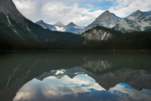
Bumpy Meadows is far more than bumps of earth; this hike offers a short but impressive ridgewalk, alpine meadows and towering walls of striking light-grey stone rising all around Pedley Pass. A tiny deep tarn is snuggled in the alpine under the curving layers of Mount Aeneas, 2680 m (8,800 ft.).
The trail is moderately steep as it ascends through the forest, but once you are at Pedley Pass the wanderings begin. The ridge climbs a rounded summit and is easy and wide. You can see both the Kootenay and the Columbia valleys from this one spot. Pastel-blue Rockies emerge to the east and north. Mount Assiniboine shines high above the rest of peaks on the northern skyline.
0 km: Parking spot, N89200-E86300. The trail begins heading west uphill on a skid road. A tall grey cliff will be on your right.
1 km: Bumpy Meadows, 2135 m (7,000 ft.), N88638-E86411; gain 120 m (400 ft.). The trails heads south to the base of a steep cliff rise and bends left. The trail gains elevation moderately toward the pass.
2.2 km: Pedley Pass, 2260 m (7,420 ft., N88379-E86999). Go either to the ridge – rounded summit up to the left – or head right on the trail, climb a little along the ridge and descend to the tarn.
Ridge – rounded summit
1 km: From the pass the trail heads east (left) to the scenic rounded summit, N88504-E87664, at 2400 m (7,900 ft.). Climb a gentle, wide and scenic alpine ridge.
Tarn
1.2 km: Tarn is about 1.2 km from the pass. Follow the open grassy ridge up about 30 m (100 ft.) to the right (southwest) and descend to the tarn, N87659-E86273. Here the ambience of the hike becomes very relaxed in the open alpine landscape. After you visit the tarn, climb back up to Pedley Pass and follow the trail back to the vehicle.
8.4 km: Total distance hiked, including visiting the ridge and the tarn.
Directions
Road: may need high-clearance 4x4 last 1.5 km
Windermere Loop Road connects with Highway 93/95 in two places. Both distances are measured from the stoplights on the highway at the turnoff to Invermere.
0 km: Drive south on Highway 93/95, from the stoplights to Invermere.
2.6 km: For north access to Windermere Loop Road, turn left (east), N93509-E71827. Drive the loop road for 3.2 km and turn off left. Or continue south on the highway to:
6.5 km: South access to Windermere Loop Road (also called Kootenay #3 Road), N90263-E73196. Take the left fork at 1 km. Drive another 3 km and turn off right. The turnoff (east) the from Windermere Loop Road, N92467-E74527, is an H shape where two major roads run parallel and the turnoff is the centre of the H; see map.
Reset odometer to 0.
Windermere Creek Road
0 km: Turn east from Windermere Loop Road.
30 m: You are on the big Westroc mine haul road (also called Windermere Creek Road.) For Bumpy Meadows, turn right (southeast) onto the mine haul road. Watch for huge mining trucks Monday to Friday. (Mount Swansea FS Road, signed, is straight across the haul road from the turnoff.)
3.1 km: Turn right (downhill).
8 km: Turn left fork (right fork is the mine entrance).
8.5 km: Turn left again.
9.5 km: Road forks into three. Take the middle branch, signed Pedley Pass (near 58 km sign). The forks do not split evenly; take the left branch, then the right, close together. The road is little more than a dirt track that climbs moderately for another 6.5 km, heading generally southeast.
13 km: Turn left. From here the road is rough and slips around a sidehill; may need a 4x4.
16 km: Spacious parking and trailhead sign, N89234-E86379, at 1970 m (6460 ft.).

Janice Strong
Janice Strong is an established professional outdoor photographer. Her images grace collections all over the world and appear in many respected publications. She is passionate about hiking and is also an avid snowshoer and skier, exploring the outdoors of the East Kootenay in southeastern BC year round.She openly shares her passion for the outdoors with others and has introduced hundreds of people to the joys of hiking. For a decade she led hikes for the City of Cranbrook – Parks and Recreation. With her guidance, many people have themselves become enthusiastic hikers.
Climbing mountains, finding new places and enjoying the experience of the journey have always been important to Janice. She cherishes the little things she sees along the trail, as well as the grand destinations.
When Janice is not writing, hiking or taking photographs, she is involved in various creative digital, website design or photographic projects for her clients. She and her husband, Jamie Levine, enjoy their rural property, near Cranbrook, BC.


