Distance

This fire road remained active until 1984, when two of the main bridges collapsed, and in 1988 the parks service banned the use of motorized vehicles on all fire roads in the park. They then decided to narrow the bridges on this trail to pedestrian width and open it up to foot and bike traffic. When the fire road was constructed in the 1930s it cut deep into the remote wilderness, and it is now the departure point of an enormous trail system extending into an immense region.
At 500 m, the distinct scent of packhorse and mule stables is unmistakable. From the stables the trail ascends modestly for about 100 m, plateaus and then descends into a grove of balsam poplar and spear grass. From this grove of deciduous trees the trail climbs gradually for about 1–1.5 km, then levels off into a coniferous forest once again.
The advantage of walking this fire road is the wide-open feeling which extends the view of the Palliser Range to the north and east (directly ahead and to the right) and Cascade Mountain to the west (left). The road also permits groups to walk side by side. For the remaining 4 km, the trail meets with wetlands of streams, ponds and marshes on either side of the road. Wetland grass varieties of horsetail, spike moss and sedge are in abundance throughout this area, with pond-lilies and duckweed being common in these ponds. Bottom-feeding ducks, shovellers and widgeons can be observed here early in the summer and again later into September to October. Yellow warblers, common yellowthroats, American redstarts and red-winged blackbirds spend time around these marshes as well.
The road ultimately drops down to the Cascade River, Cascade Bridge and the campground, which is a fully equipped backcountry campground containing tent pads, rough table and chairs and an outhouse.
History
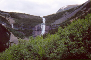
Cascade mountain and river take their names from the waterfall at the southeast end of the mountain. “Mountain where the water falls” comes from the Native word “minihapa.” James Hector abbreviated the meaning, and in 1858 he named it on August 15 and climbed it on August 16, even though he did not reach the summit. The summit was not achieved until 1887, by L.B. Stewart and Tom Wilson. In 1911 Cascade River and Valley obtained their official names from the mountain of the same name.
Directions
At the east entrance into Banff Township get onto the Lake Minnewanka Road. Take this road for 6.5 km to the Upper Bankhead Picnic Area parking lot. A sign marks the trailhead at the east end of the parking lot.