Distance
From the ridge looking east, you can see the blocky curtains of sharply inclined rock of the Septet Range. Extensive alpine meadows and larch trees soften the impressive landscape, adding foreground to the unequalled 360 degree view. The sprawling slopes of an unnamed glacier by the Quintet Peaks lines the southern view. Sharing that view are the open slopes of Bugaboo Pass and small Silver Basin.
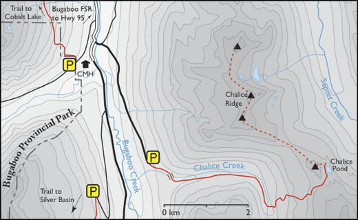
Tucked just below the picturesque Chalice Ridge, is a small alpine pond and an undefined wilderness campsite. The unofficial name for this tarn is Chalice Pond. The tarn is less than 100 m across and is often omitted on topographic maps. You could hike to Chalice as a long day hike, but why not backpack up to the Chalice Pond and explore the area for two or three days. There is enough to keep most hikers fulfilled.
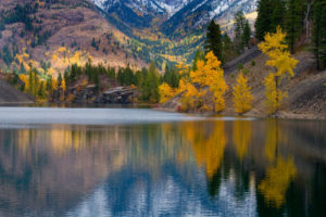
In autumn, at Chalice Pond the reflections of the golden larch needles illuminated by the morning sun shines like slivers of yellow tinsel. The larch contrasts with a navy-blue, high-elevation sky and the whole landscape is painted in glorious colour.
Up from Chalice Pond, a small cairn and plaque built in 1987 mark a memorial to Helen and Hal Bavin. Canadian Mountain Holidays (CMH) calls this tarn “Bavin Lake.” CMH operates the Bugaboo Lodge and they coordinate all the heli-hikers and helicopter trips in the Bugaboo Valley.
The one disadvantage of the hike to this wonderfully scenic ridge is the frequency of heli-hiking flyovers and the occasional landing of the choppers full of hikers. It is not a place for remote getaways.
After a few scenic days by the Chalice Pond, finding the route back out across the alpine meadows is tricky. If you come to an alpine creek crossing, backtrack to the forested main trail and look for flagging tape or cairns.

The 4.2-km ridgewalk from Chalice Pond is a fabulous day hike on a leisurely, undulating and wide alpine ridge. Savour the panoramic views of the Bugaboo Spires and Bugaboo Glacier. Hike northwest on the ridge and gain 180 m (600 ft.) to the first summit, in 2.3 km. The second summit is the highest of the hike at 2460 m (8,100 ft). There is no water on the ridgewalk. Past the second summit you can descend to from the ridge on a moderate route (east) to two lakes, 2286m (7,500ft). Descend to the lower lake for the nicest swimming. Routefind back to Chalice Pond along the open forest. Trail
0 km: From the parking lot at the top of the Chalice Creek Road, hike the partially overgrown trail heading southeast. A well-worn path snakes between the canopy of alders.
150m: Beside the pounding creek, a rough trail turns left, uphill in the steeply forested slope. Gain 120m (400ft) then the trail crosses the creek.
800m: Bridge crossing on two logs spanning the current. Although the creek has leveled out significantly, the crossing may be unnerving when the logs are wet or in the morning damp with dew. Crawling across the big logs may be a safe choice. When the logs are dry, hikers can walk across the “bridge.” The trail continues on the road (east) uphill, gradually gaining elevation for 1.4 km to the end of the logging road.
2.2 km: The trail leaves the clearing and heads across a couple of wet spots and into the forest, where it winds for about 800 m, then bends south.
3.3 km: Alongside the calm creek, the trail either crosses on a log “bridge” or, if the logs are gone, the trails continues another 200 m to where (in summer) you can easily wade the ankle-deep water, N19400-E24600.
After the creek crossing, look around for the well-worn trail heading uphill (east) into the forest. It briskly gains elevation up a series of switchbacks. Climb through the forest for about 1.6 km and gain another 400 m (1300 ft.). The trail is easy to follow, but there may be several blowdowns to scramble over. Trail was clear in 2008.
3.8 km and 4.1 km: Two scenic springs for water supply are the last water before Chalice Pond. Gradually, as you gain elevation the spruce and fir forest thins into a mature larch stand.
5 km: Break out of the forest, N19800-E25500, onto a meadow at the pass at 2286 m (7,500 ft.) for the first uninterrupted views of the Bugaboo Spires. From the alpine pass, follow flagging tape or cairns for the route (north) across the undulating meadows for 0.5 km.
5.6 km: Crest a small ridge and see Chalice Pond and the camping spot. The Septet Creek valley descends steeply from this ridge and waterfalls stream down the mountainsides.
6 km: The northern shore of Chalice Pond.
Directions
last 2.2 km high-clearance; growing in with alders, may scratch your vehicle.
The Chalice Creek trailhead is about 1.5 hour drive on gravel roads from Highway 95 at Brisco (Brisco is about 26 km north of Radium). Follow posted road signs to Bugaboo Provincial Park.

Janice Strong
Janice Strong is an established professional outdoor photographer. Her images grace collections all over the world and appear in many respected publications. She is passionate about hiking and is also an avid snowshoer and skier, exploring the outdoors of the East Kootenay in southeastern BC year round.She openly shares her passion for the outdoors with others and has introduced hundreds of people to the joys of hiking. For a decade she led hikes for the City of Cranbrook – Parks and Recreation. With her guidance, many people have themselves become enthusiastic hikers.
Climbing mountains, finding new places and enjoying the experience of the journey have always been important to Janice. She cherishes the little things she sees along the trail, as well as the grand destinations.
When Janice is not writing, hiking or taking photographs, she is involved in various creative digital, website design or photographic projects for her clients. She and her husband, Jamie Levine, enjoy their rural property, near Cranbrook, BC.