Distance

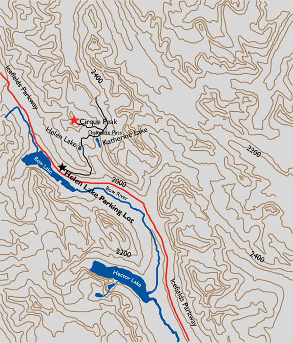
Finally, after you’ve been hiking for approximately an hour, the forest vanishes, yielding vistas of Dolomite Peak directly ahead and Cirque Peak to the left. The remainder of the trek to Lake Helen is through an alpine meadow, with Cirque Peak dead ahead in the line of sight until you reach the lake. Lake Helen is more of a large pond amidst this alpine meadow, but even so, it is a tranquil spot to stop and look around before hustling up to Dolomite Pass. The trail winds around the east side of the lake and suddenly takes up with the hillside leading to the summit of Dolomite Pass. The brief increase in elevation is achieved more quickly by staying to the left at the first trail junction (GPS: N51 41 20.1 W116 24 36.0), partway up the hillside. Within a few quick minutes, Dolomite Pass is conquered.
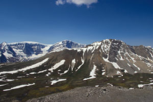
The way to the Cirque Peak summit is evident, as climbing the exposed east shale shoulder onto the ridge is obvious and should take only one to one and a half hours. There is a small amount of scree and shale, but nothing substantial. For the most part, it is a straightforward walk up the side of the mountain to the ridge and onto the summit. The scenery from the top is unique, allowing a superior view of the Wapta Icefield to the southwest. Observation Peak is a mere 5.2 km away to the northwest.
History
In July of 1899 guide Ralph Edwards was engaged to take four explorers over the Pipestone Pass, down the Siffleur River to the Saskatchewan, up to Bear Creek (today called the Mistaya River) and then up to Bow Lake. The purpose of the expedition was to do some climbing and adventuring around the Bow Lake area. The party consisted of two lawyers, George Weed and Charles S. Thompson, and two clergymen, C.L. Noyes and Harry P. Nicholls. Of these four men, Edwards wrote:
There is an old saying used to describe a person of outstanding character that when ‘God made him He broke the mould,’ thus signifying that there were no others quite his equal; if this be so, in the present instance He broke four moulds.
After several days on the trail, the group found themselves “… between the valley of the Pipestone and the Bow.” What they did not know was where they were going to come out. One evening near Bow Lake, after supper, Edwards suggested that the following day the group should stay camped there and do some climbing while he would set out to find a shortcut to the Bow Valley somewhere north of Hector Lake. Edwards and Weed departed early the following morning, while the rest of the group climbed a nearby mountain and subsequently named it Observation Peak.
After facing a rockslide, which required clambering over, and then what looked like a box canyon to navigate, Edwards finally spotted a gap in the valley they were exploring. The gap went up a gentle slope for perhaps 150 feet. Behind it there were no mountains, and from their vantage point it appeared to flatten out. They had discovered what they had set out in search of. According to Edwards’s book Trail to the Charmed Land, “The pass was actually a beautiful, almost level alpine meadow, and to our left lay a lovely blue lake nestled at the base of the steep cliffs which terminated the eastern range.” The following evening, when the entire group camped at Lake Katherine, there was no wood for a fire, no sign of previous fires and not even a single teepee pole in sight. Edwards and Weed were quite certain they were the first humans ever to cross this pass.
Dolomite Pass got its name because of their similarity to the formations of the Dolomites of Italy. Lakes Katherine and Helen are named for the daughters of Rev. Nichols. Cirque Peak, named much later, in 1909, is so called simply because there is a large cirque at the base of the cliff.
Directions
Trailhead: Drive north on the Icefields Parkway for 33.8 km from where it intersects with the Trans-Canada Highway 2 km west of Lake Louise. Watch for the Lake Helen parking lot on the right side of the Parkway.