Distance
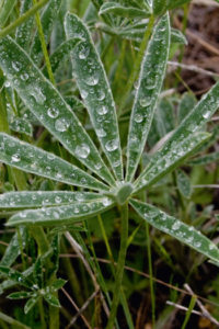
Other shorelines are abrupt eroding banks that dip for a hundred metres down into the wetland. Explore the forest-shaded shallow water and deep sun-drenched pools along the banks of the slow deliberate current.
The mighty Columbia River begins in Columbia Lake near Canal Flats. It flows calmly and serenely northward to Windermere Lake (Invermere), where it spreads out in the wide expansive wetland and continues meandering to just north of Golden. From Golden the river picks up speed on its way to Astoria, Oregon, and the Pacific Ocean.
The stretch from Windermere Lake to Golden is the important Columbia Valley Wetland. The river sprawls north in a vast, 22,000-hectare riparian area, The 180-km-long Columbia Wetlands is unique in western North America for its natural condition and large scale. It is one the largest remaining wetlands on the continent. The area (wetland and surrounding slopes to the ridgetops) is home to, and of migratory importance to, 260 bird species. At its narrowest section, near Invermere, the wetland is 2 km across. The Columbia floods and braids across the lowlands in channels of different depths and widths, creating a variety of water-dependent ecosystems.
For further reference, see Friends of the Columbia Valley Wetland and Radium’s Wings over the Rockies Contact Information and References.
Canoeing and kayaking
Canoes and kayaks are the best way to explore this unique ecosystem. You can put in to Windermere Lake and pull out later in the day at Radium, about 16 km distant. Or it is a three-day easy paddle from Windermere Lake north to the town of Parson. The channels braid and recombine along this scenic semi-wilderness canoe trip.
Hikes
Several short walks follow the curves of the shoreline. Please take care of this valuable resource along the Columbia River.
Further explorations – other East Kootenay wetlands
Creston Valley Wildlife Management Area, is similar to the Columbia Valley Wetlands. The Creston area wetlands are dependent on levees and water control.
For the Columbia Lake east side hike by Canal Flats, see Chapter 4. Columbia Lake is the source of the mighty Columbia River, and the east side of the lake is a protected area where motorized use is limited. Hike the shores just north of Canal Flats on kilometres of old roadways and across hectares of the open meadows and forested slopes.

The historic Earl Grey Pass trail traverses 60 km (38 mi.) through the wilderness in the park’s northern reaches. The trail climbs from Toby Creek, crosses the Purcell Mountains and descends into Hamill Creek by Lardeau on Kootenay Lake.
The trail was named after a Governor General of the Laurier era, Earl Grey. In 1909 he and his crew travelled across Canada, and in an extremely remote voyage they traversed the Purcell Mountains.
After Earl Grey’s visit, he proposed the protection of the Purcell Mountains as a national park. Still, nothing was done until citizen advocates, six decades later, restored the protection issue. It took two more decades of active citizen commitment to the Purcells to complete the conservancy as a park. Finally after very much hard negotiation, in 1995 the BC government extended the boundaries of PWC on both the east and west flanks and granted it Class A provincial park status, “full legislated protection.”
Management
Today, the Purcell Wilderness Conservancy is a 200,173-ha area that is managed for a wilderness priority. It is renowned for its outstanding scenery and wilderness backcountry recreation, but the park’s size, remoteness and the length of its trails, limits day hikers in the park.
Directions
Road: any vehicle
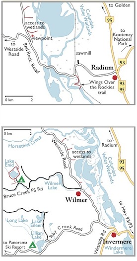
At least two different parking, viewing and hiking locations for the Columbia Valley Wetlands.
Invermere/Wilmer access
Wilmer Marsh Wildlife Reserve
0 km: Leave Highway 93/95 and turn west toward Invermere. Drive downhill and cross Columbia River bridge.
2 km: At stoplights (Athalmer), go straight, heading toward downtown Invermere.
2.4 km: Just before the top of the hill, turn right (north) onto Panorama Resort/Wilmer Road.
3.8 km: Turn right onto Wilmer/ Westside Road and cross Toby Creek Bridge.
6.4 km: From the town of Wilmer, turn right (north) onto Westside Road and gravel.
7.9 km: Park at a wide spot in the gravel road, at a sign with a picture of a loon that reads “Federal Government Protected Land” (1.5 km north of Wilmer).
Radium access
Wings over the Rockies
0 km: Four-way stop in Radium at the Highway 93/95 junction. Turn west, downhill.
1.5 km: At the bottom of the hill, take left fork (away from the sawmill).
1.9 km: Just past the railway tracks, park along the road close to a bend in the river for the Wings over the Rockies trail; a 1- or 2-km trail heads south around the curves in the wetlands.
Another Radium Option
3 km: Continue west along the main road and cross Columbia River bridge.
3.8 km: Turn right (north) onto Red Rock Road. (Left fork heads to Westside Road.)
3.9 km: Take small gravel road on right (east) to a Radium Wetlands Viewpoint. Park here or continue north.
4–7 km: Continue past the viewpoint turnoff and park along Red Rock Road.
Columbia Wetlands Maps
Radium (top), Invermere (bottom)
2 Southern Purcell Mountains
Hourglass Lake reflection with route to Upper Hourglass Lake on the rockslide in the background.
Southern Purcell Mountains Road Map
See also the detail map of Moyie, Cranbrook and Kimberley area
St. Mary River
Road directions for St. Mary Lake Road and for Dewar and Meachen Creek FS roads
Access for hikes:
Kimberley Nature Park – Sunflower Hill
St. Mary’s Alpine Provincial Park – Mortar and Pestle Lake, Manson Col.
Purcell Wilderness Conservancy, south access
Dewar Creek Hot Springs
Meachen Creek Falls
White Boar Lake
Hourglass Lake
Haystack Lake
Road map. See also the detailed road map of Meachen Creek, Perry Creek and Moyie River roads.
St. Mary Road to Dewar Creek Road
Map: 82F/9 St. Mary Lake (NAD27)
Drive
From Highway 95A about 500 m north of Marysville, turn west onto St. Mary Lake Road.
0 km: Junction of Highway 95A and St. Mary Lake Road
2 km: Sunflower Hill, Kimberley Nature Park; small dirt road on right; see #34I Kimberley Nature Park-Sunflower Hill.
2.5 km: Kimberley Campground.
16 km: For Meachen Creek hikes (27 km sign), turn south (left) just before the lake, on St. Mary River FS Road (signed).
16.6 km: St. Mary Lake; pavement ends; road climbs above the lakeshore.
29 km: Continue straight for Dewar Creek, N00025-E48500. The left fork is for Redding Creek Road, Grey Creek Pass (39 km sign).
38.1 km: Dewar Creek Road; turn right (north) 500 m beyond the prominent White Creek bridge (49 km sign), N08060-E44800. Avoid left turn (west), St. Mary River west fork. Keep to the main Dewar Creek FS road, as many new side roads branch out.
Reset odometer to 0.
Dewar Creek FS Road, continued from St. Mary Lake Road above
Access for hikes:
St. Mary’s Alpine Provincial Park, south and west access
Purcell Wilderness Conservancy, south access
Dewar Creek Hot Springs
Map: 82F/16 Dewar Creek (NAD27)
Road: High-clearance vehicle
0 km: St. Mary River Road and Dewar Creek FS Road (49 km sign).
8 km: Continue straight on the main road for Dewar Creek (8 km sign). Or for south access to St Mary’s Alpine Provincial Park, turn steeply right uphill N14600-E43500, see #20 Hikes in St. Mary’s Alpine Provincial Park.
15 km: Continue straight on the main road for Dewar Creek. Or for the west access to St Mary’s Alpine Provincial Park, turn right uphill N19900-E39400, see Drive: west access to St. Mary’s Provincial Park in entry #20.
20.6 km: Turn right.
21.4 km: Turn left.
27 km: Road ends at parking lot for Dewar Creek Hot Springs, N26000-E38300. Trailhead for Dewar Creek Hot Springs take the left fork. The Wesley Creek trail is to the right (east), not described in this edition. It is a hunter access trail that may or may not be usable. It is the north access to St. Mary’s Alpine Provincial Park for Mount St. Mary and Bleak Lake.
Purcell Wilderness Conservancy
The Purcell Wilderness Conservancy (PWC) contains an outstanding diversity of natural features. From the Dewar Creek Hot Springs in the valley bottom up long forested valleys to the soaring peaks of the Purcell Mountains, the PWC protects amazing wilderness. It is the largest intact ecosystem in southeastern BC, according to a 1996 “management direction statement” by BC Parks.
The highest peak is Mount Truce, at 3250 m (10,660 ft.). Other summits reach over 3200 m (10,500 ft.) and active glaciation still dominates in many upper basins.
Roads and access
Road access into the park is often many kilometres distant from the park boundaries. At Findlay or Dutch creek, for example, the end of the road is 30 km away. At Toby Creek the road ends near the confluence with Jumbo Creek. Yet, along Dewar and Wesley creeks the road end is near the boundary.
PWC is to be left wild, without trail signs, bridges or other facilities. Visitors must rely on their own wilderness skills and independence in this remote area.
Most of the creeks are not bridged and many are in flood with winter meltwater into July. A few crossings, however are essential.
Trail descriptions for the Early Grey Pass Trail, Toby Creek to Earl Grey Pass, Fry Creek Trail and the Dewar Creek Trail are detailed on the BC Parks website December 2010, http://www.env.gov.bc.ca/bcparks/explore/parkpgs/purcell/trails.html
This is a quote from the webpage:
… The trail crosses Hamill Creek for the first time on a cable car installed prior to 1929 at the site of an old bridge. BC Parks has recently replaced all cable cars. Ensure that you bring gloves for pulling the car along the cable.… access the west side of the park on hiking trails up Fry, Carney and Hamill Creeks. Day hikes are popular on the lower reaches of Hamill Creek to visit the old compressor site via the cable cars and on Fry Creek to see the canyon. Rivers may be impassable during flood season, usually until the end of July. There are few bridges on the east side of the Park. Some bridges and five cable cars are in place on the lower end of Hamill Creek and Fry Creek. (Bring gloves to pull yourself across on the cable cars.).”
Other West Kootenay side crossings are open: a bridge over Fry Creek Canyon and a cable car over Carney Creek near the bottom of the trail to Kootenay Joe Ridge. Wear gloves when pulling the cables cars, as the cables are greasy and they may have sharp metal wires.
On the East Kootenay side, the bridge over Wesley Creek on the Dewar Creek trail was replaced in 2008 and the trail was cleared.
Radium access
Wings over the Rockies
0 km: Four-way stop in Radium at the Highway 93/95 junction. Turn west, downhill.
1.5 km: At the bottom of the hill, take left fork (away from the sawmill).
1.9 km: Just past the railway tracks, park along the road close to a bend in the river for the Wings over the Rockies trail; a 1- or 2-km trail heads south around the curves in the wetlands.
Another Radium Option
3 km: Continue west along the main road and cross Columbia River bridge.
3.8 km: Turn right (north) onto Red Rock Road. (Left fork heads to Westside Road.)
3.9 km: Take small gravel road on right (east) to a Radium Wetlands Viewpoint. Park here or continue north.
4–7 km: Continue past the viewpoint turnoff and park along Red Rock Road.

Janice Strong
Janice Strong is an established professional outdoor photographer. Her images grace collections all over the world and appear in many respected publications. She is passionate about hiking and is also an avid snowshoer and skier, exploring the outdoors of the East Kootenay in southeastern BC year round.She openly shares her passion for the outdoors with others and has introduced hundreds of people to the joys of hiking. For a decade she led hikes for the City of Cranbrook – Parks and Recreation. With her guidance, many people have themselves become enthusiastic hikers.
Climbing mountains, finding new places and enjoying the experience of the journey have always been important to Janice. She cherishes the little things she sees along the trail, as well as the grand destinations.
When Janice is not writing, hiking or taking photographs, she is involved in various creative digital, website design or photographic projects for her clients. She and her husband, Jamie Levine, enjoy their rural property, near Cranbrook, BC.