10.5 km
Distance
Distance
NominalElevation Gain (m)
ModerateDifficulty
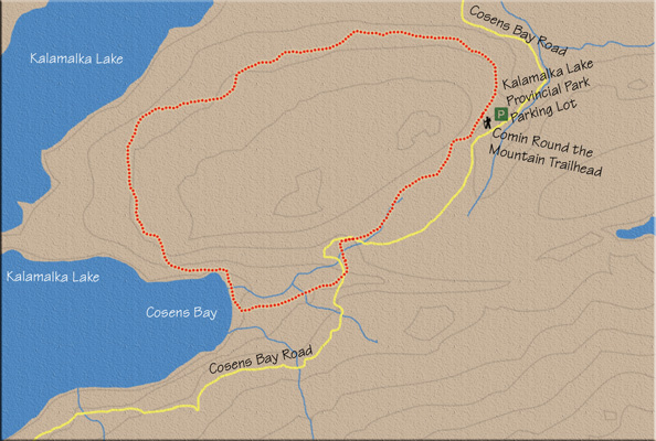
This journey circumnavigates many of the hiking trails of Kalamalka Lake Provincial Park. With this being an outer loop walk, vistas of Kalamalka Lake and the surrounding hills abound for most of the journey.

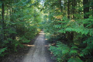
1. Find the trailhead at the northeast end of the parking lot to begin travelling a narrow path. Almost immediately, the trail veers upward to the left at a sign confirming the trail.
2. Moderate elevation is gained for the next 10–15 minutes. About 15 minutes from the trailhead, another sign keeps you on the correct trail. This one gives directions to The Wall up to the left, but you want to stay on the main trail, continuing straight and heading downhill.
3. All along this hike, minor trails intersect and join the main route, but staying on the core trail is straightforward.
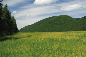
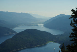
4. The area becomes open, wide and vast about 30–35 minutes into the hike, and with this expansive view, the shimmering waters of Kalamalka Lake, down to your right, become the focal point of the hike. Five minutes later you will come to another sign, on your left, marking the trail called The Parabola. Stay on the main path, heading straight.
5. The remainder of the trail continuously heads in and out of a sparse mixed forest of pine and alders, while rolling almost unnoticeably up and down.
6. You will come to a third noteworthy junction nearly 10 minutes from The Parabola intersection. Once more, the junction approaches from the left; the sign signifies The Lookout as the trail’s name.
7. Almost as soon as you pass The Lookout junction, the trail dips down to join a wider, more travelled one. You will pass a sign on your left announcing that the trail you are currently on is at the beginning (or the end) of the trail called Comin’ Round the Mountain. Join this new trail by turning left, placing yourself on Corral Trail. Its namesake is soon apparent. Corral Trail comes up on your right from the Red Gate parking lot. The intersection of these two footpaths marks 4.3 km into the hike.
8. Continue on Corral Trail for another 15 minutes until you arrive at a fork. Grassland Trail goes down to the right, while Corral Trail is the left fork heading upward. Take Corral Trail, which ultimately takes you to Cosens Bay Beach 1.3 km away.
9. A couple of minutes up Corral Trail, you’ll pass a magnificent lookout just off the right side of the path. There is a comfortable, inviting bench here that encourages you to take a break and enjoy a spectacular view of Kalamalka Lake. You really should stop and take a look. Don’t be in too much of a rush to get back to your car – you have all day.
10. After another two minutes or so, the trail passes another park bench to your right. At this spot, the trail takes an unannounced dip down toward the lake as it swings away from a straight, level, single-track path directly ahead of you. There are no direction signs here as you drop downward on switchbacks, but I can guarantee you this is the right way.
11. Just over 10 minutes later you will approach Sidewinder Trail and its marker on your left. Stick to the main trail and a few minutes later you will be on Cosens Bay beach.
12. Walk the beach trail for about five minutes to find the end of Cosens Bay Trail (see the Cosens Bay hike for details). As you access Cosens Bay Trail, you have trekked about 6.5 km so far.
13. Continue up Cosens Bay Trail for 3.5 km to return to your vehicle.
2. Moderate elevation is gained for the next 10–15 minutes. About 15 minutes from the trailhead, another sign keeps you on the correct trail. This one gives directions to The Wall up to the left, but you want to stay on the main trail, continuing straight and heading downhill.
3. All along this hike, minor trails intersect and join the main route, but staying on the core trail is straightforward.
4. The area becomes open, wide and vast about 30–35 minutes into the hike, and with this expansive view, the shimmering waters of Kalamalka Lake, down to your right, become the focal point of the hike. Five minutes later you will come to another sign, on your left, marking the trail called The Parabola. Stay on the main path, heading straight.
5. The remainder of the trail continuously heads in and out of a sparse mixed forest of pine and alders, while rolling almost unnoticeably up and down.
6. You will come to a third noteworthy junction nearly 10 minutes from The Parabola intersection. Once more, the junction approaches from the left; the sign signifies The Lookout as the trail’s name.
7. Almost as soon as you pass The Lookout junction, the trail dips down to join a wider, more travelled one. You will pass a sign on your left announcing that the trail you are currently on is at the beginning (or the end) of the trail called Comin’ Round the Mountain. Join this new trail by turning left, placing yourself on Corral Trail. Its namesake is soon apparent. Corral Trail comes up on your right from the Red Gate parking lot. The intersection of these two footpaths marks 4.3 km into the hike.
8. Continue on Corral Trail for another 15 minutes until you arrive at a fork. Grassland Trail goes down to the right, while Corral Trail is the left fork heading upward. Take Corral Trail, which ultimately takes you to Cosens Bay Beach 1.3 km away.
9. A couple of minutes up Corral Trail, you’ll pass a magnificent lookout just off the right side of the path. There is a comfortable, inviting bench here that encourages you to take a break and enjoy a spectacular view of Kalamalka Lake. You really should stop and take a look. Don’t be in too much of a rush to get back to your car – you have all day.
10. After another two minutes or so, the trail passes another park bench to your right. At this spot, the trail takes an unannounced dip down toward the lake as it swings away from a straight, level, single-track path directly ahead of you. There are no direction signs here as you drop downward on switchbacks, but I can guarantee you this is the right way.
11. Just over 10 minutes later you will approach Sidewinder Trail and its marker on your left. Stick to the main trail and a few minutes later you will be on Cosens Bay beach.
12. Walk the beach trail for about five minutes to find the end of Cosens Bay Trail (see the Cosens Bay hike for details). As you access Cosens Bay Trail, you have trekked about 6.5 km so far.
13. Continue up Cosens Bay Trail for 3.5 km to return to your vehicle.
Directions
In Vernon, at the major intersection of Highway 97 (32nd St.) and 25th Ave., drive eastward, following the signs for Kalamalka Lake, Lumby, Nelson and Highway 6 South. Turn right onto Highway 6 and drive for less than a kilometre, looking for Kalamalka Lake Rd. Turn right on Kalamalka Lake Rd. and stay on it for a little over 6 km before turning right on Coldstream Creek Rd. Within 800 m, turn left onto Cosens Bay Rd. The parking lot is another 800 m down the road. Alternatively, follow Provincial Park signs directing you to Cosens Bay, starting at the intersection of Highway 6 and Kalamalka Lake Rd. through to the parking lot.