Distance
History
At the lake’s outlet creek are the remnants of an abandoned log structure bracing against the bedrock. It was built in the early 1900s as part of a dam and log flume system. This historic flume carried water down from Cooper Lake to the sawmill town of Lumberton along the highway. The water poured over giant waterwheels, which powered the early sawmill equipment. You will pass some of the old stone and cement ruins of the Lumberton buildings just as you turn off Highway 3/95 on the way to this hike, at the beginning of the Lumberton road.
0 km: From the parking spot on the Cooper Lake FS road, hike uphill southwest through the clear-cut and follow a defined trail through the forest. Once on the trail, it is a straightforward pleasant hike with occasional openings through the trees to see a rock bluff and look down to the creek.
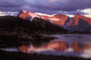
3.3 km: Cooper Lake, N63176-E63749, is at 1600 m (5,280 ft.) elevation.
Directions
Road: any vehicle
The road to Cooper Lake is about an hour’s drive from Cranbrook on active logging roads. Take Highway 3/95 south of Cranbrook for 12 km (9 km north of Moyie Lake).
0 km: Turn west (right turn from Cranbrook) off the highway, N75148-E81785, onto the signed Lumberton FS road. Stay to the main gravel road, as many new logging roads branch from the main Moyie/Lumberton FS road.
5.3 km: Obscured hairpin curve. Watch for oncoming vehicles on this narrow curve.
6.8 km and 8.2 km: Parking for Moyie Falls (after 7 km sign). Park along Lumberton Road: left side, wide pullouts, two road accesses, not signed. The pullouts are along a winding set of several short switchbacks. The side trip to Moyie Falls is a short hike of about 1 hour return. Hike south downhill from Lumberton Road on either of two old mining roads to the river. It is hard to see the tumbling water unless you cross the unbridged Moyie River. Sometimes in summer you can step on rocks to cross. Head upstream about 400 m. Return to the vehicle and continue the drive to Cooper Lake
9 km: Take the left fork onto the Moyie River FS road (9 km sign). (Don’t take the right fork, Lumberton Road; continue straight ahead.) From here the numbered markers restart from 0; stay on the main road, between the 5 and 8 km signs. There are many logging roads here.
18.5 km: Right fork, signed Moyie Main Road (just before 10 km sign).
20 km: Turn left across bridge on Moyie Main Road (12 km sign). (Avoid the North Moyie right fork.)
22.4 km: Stay on main road, right fork (before 14 km sign). Don’t take Powerline Road left.
25 km: You may see an old trailhead sign here tossed in the bush. The trail has been rerouted to avoid a tricky creek crossing, 1490 m (4,900 ft.). Continue about 100 m past the old trailhead.
25.1 km: Turn left onto the new Cooper Lake FS road (yellow sign), N66008-E64613. Drive south, crossing a new bridge at 800 m. Park before you cross the second bridge, about 200 m. The trail is uphill on the southwest side (right), through a cutblock, N65164-E64359, at 1480 m (4,860 ft.)

Janice Strong
Janice Strong is an established professional outdoor photographer. Her images grace collections all over the world and appear in many respected publications. She is passionate about hiking and is also an avid snowshoer and skier, exploring the outdoors of the East Kootenay in southeastern BC year round.She openly shares her passion for the outdoors with others and has introduced hundreds of people to the joys of hiking. For a decade she led hikes for the City of Cranbrook – Parks and Recreation. With her guidance, many people have themselves become enthusiastic hikers.
Climbing mountains, finding new places and enjoying the experience of the journey have always been important to Janice. She cherishes the little things she sees along the trail, as well as the grand destinations.
When Janice is not writing, hiking or taking photographs, she is involved in various creative digital, website design or photographic projects for her clients. She and her husband, Jamie Levine, enjoy their rural property, near Cranbrook, BC.


