6 km
Distance
Distance
232mElevation Gain (m)
ModerateDifficulty
This pleasant 3 km one-way stroll through open fields to Kalamalka Lake is ideal on a hot Okanagan day. A dip in the warm waters of Kalamalka Lake is a tremendous reward for such little effort.

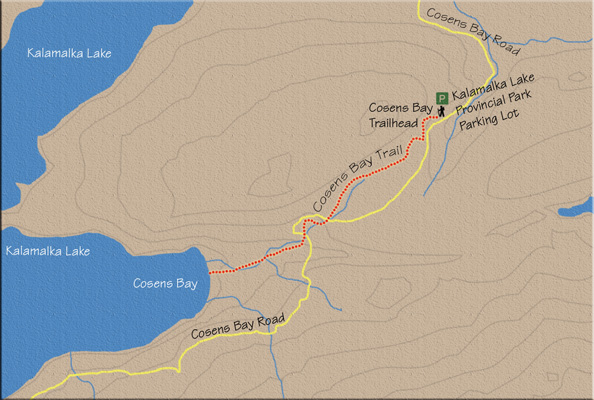
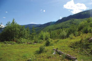
1. Leaving the parking lot, the trail gently climbs briefly through a sparse forest, opening to a vast meadow after just a few minutes of walking. The grasses in this broad meadow are green only for a short time during spring and early summer. By August these rolling hills of flowers and green grass will have evolved into hills of burnt-brown, empty stalks.
2. The way is obvious even with the multitude of cycle paths intersecting the main trail. Well-placed signage guides you. The “summit” of the trail is reached after about 500 m along the trail. The elevation of the summit is 559 m above sea level. Although you’ve gained 67 m, the trail now descends to Kalamalka Lake with a drop of 152 m.
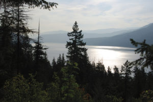
3. From the summit, you receive your first glimpse of Kalamalka Lake as the trail begins its slow, steady descent through openness to the shores of the wondrous “lake of many colours.” You cross the gravelled Cosens Bay Rd. twice as it winds its way down to the lake, having left the parking lot where the trail did. The first crossing is within five minutes of leaving the summit, and the second encounter is another 10 minutes after that.
4. At the first of the two crossings, a sign signifies that there is 1.6 km remaining in your hike. You have travelled 1.4 km so far. The trail dips into a clump of forest on the other side of the road and then crosses a charming little wooden bridge.
5. On sunny, hot days, welcome shade is found as the trail meanders in and out of small islands of trees. With a sign marking 1.1 km to go, you cross Cosens Bay Rd. the second time. The patches of forest are left behind as you break out into another field of wild grasses.
6. Ten minutes later, at the far end of this meadow, trees blot the view of the lake once more. However, when this brief interruption is over, an expansive view of the lake greets you. A 10- to 15-minute drop delivers you to the sandy shoreline of Cosens Bay.
7. This is a magnificent place to swim, sit, think or just play in the sand. Amenities include picnic tables and an outhouse.
2. The way is obvious even with the multitude of cycle paths intersecting the main trail. Well-placed signage guides you. The “summit” of the trail is reached after about 500 m along the trail. The elevation of the summit is 559 m above sea level. Although you’ve gained 67 m, the trail now descends to Kalamalka Lake with a drop of 152 m.
3. From the summit, you receive your first glimpse of Kalamalka Lake as the trail begins its slow, steady descent through openness to the shores of the wondrous “lake of many colours.” You cross the gravelled Cosens Bay Rd. twice as it winds its way down to the lake, having left the parking lot where the trail did. The first crossing is within five minutes of leaving the summit, and the second encounter is another 10 minutes after that.
4. At the first of the two crossings, a sign signifies that there is 1.6 km remaining in your hike. You have travelled 1.4 km so far. The trail dips into a clump of forest on the other side of the road and then crosses a charming little wooden bridge.
5. On sunny, hot days, welcome shade is found as the trail meanders in and out of small islands of trees. With a sign marking 1.1 km to go, you cross Cosens Bay Rd. the second time. The patches of forest are left behind as you break out into another field of wild grasses.
6. Ten minutes later, at the far end of this meadow, trees blot the view of the lake once more. However, when this brief interruption is over, an expansive view of the lake greets you. A 10- to 15-minute drop delivers you to the sandy shoreline of Cosens Bay.
7. This is a magnificent place to swim, sit, think or just play in the sand. Amenities include picnic tables and an outhouse.
Directions
In Vernon, at the major intersection of Highway 97 (32nd St.) and 25th Ave., drive east, following the signs for Kalamalka Lake, Lumby, Nelson and Highway 6 South. Turn right onto Highway 6 and drive for less than a kilometre, looking for Kalamalka Lake Rd. Turn right on Kalamalka Lake Rd. and stay on it for a little over 6 km until turning right on Coldstream Creek Rd. Within 800 m, turn left onto Cosens Bay Rd., which services Kalamalka Lake Provincial Park. The parking lot is another 800 m down the road. Alternatively, follow Provincial Park signs directing you to Cosens Bay, starting at the intersection of Highway 6 and Kalamalka Lake Rd. through to the parking lot.