Excerpt From: Gerry Shea. “Popular Day Hikes 3.” iBooks.
Distance

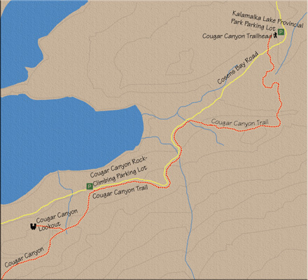
At the Kalamalka Lake parking lot, look around for the large sign for the High Rim Trail (HRT). Much of the lower section of the trail includes the HRT. Beyond the sign, follow the narrow, single-track path along a barbed-wire fence on your left through an open, grassy hillside. Within a few minutes the trail brings you to a gate marked with a large NO TRESPASSING sign. Continue alongside the fence for a few more minutes until the path leaves the fenceline and begins its descent into the Beaver Valley. The edge of this drop forms the 1 km mark of the hike.
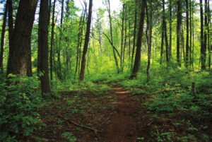
2. Continue the trek, following the well-placed HRT signage. The trail levels off in the valley bottom at the 1.2 km mark, where a sign steers you to the right. After the blazing sun, a gorgeously thick forest is a welcome change in this region of open meadows.
3. A few trails intersect the main trail that you’re on, but continue straight. At the 2.4 km point, the trail, and this beautiful Okanagan forest, deposits you onto Cosens Bay Rd. This intersection is the lowest point of your journey, at 474 m, while the precarious perch you are hiking toward sits at 646 m – a gain of 172 m.
4. Turn left and hike up the road for 2 km while enjoying views of the shimmering blue-green water offered by Kalamalka Lake below you on your right. About 1 km up the road, power lines pass overhead and the road soon levels off.
5. Continue following the gravel road until you approach the marker on the left that indicates 4 km of road from the parking lot. Just beyond this, both trail and road cross underneath the power lines once again. On a rusted section on one of the power poles, the words COUGAR CANYON HIKING are clearly marked with white paint. An equally noticeable white arrow directs you to the left, into a forest.
6. Just beyond this marked pole there is another parking lot that is mainly used by rock climbers, as Cougar Canyon has some of the best rock walls in the Okanagan Valley. This parking lot is the beginning of the second, much shorter route into the canyon area.
B:
1. This second trail begins as an old forestry road and heads off into a forest. Five to ten minutes from the parking lot, the old forestry road enters a wide clearing with an information kiosk at the far end. This kiosk is used by rock climbers and is supplied with maps of climbing routes as well as a chalkboard for noting route conditions. A sign attached to the kiosk warns against dropping rocks or debris over the edge of cliffs onto unsuspecting climbers.
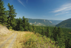
2. The road has now been transformed into a narrow path that begins to climb and continues upward for about 10 minutes. When the trail plateaus, an abundance of signs once again warn about the hazards of tossing rocks over the edge of the cliffs. On your right a well-positioned park bench beckons your weary body. Take a seat and enjoy the spectacular view of Kalamalka Lake; there’s no rush to get anywhere up here.
3. A few minutes beyond the bench, you will reach an important signed intersection. Going to the right will transport you to one of the best viewpoints in the region, while taking the left fork will drop you down into one of the most unique rock formations in the area. This is one of those rare occasions when you take both forks in a path.
4. The viewpoint is only five minutes away and the canyon floor is just twice that distance, so go and enjoy the viewpoint first, because you may not feel like it after you crawl up out of the canyon.
5. Once on the canyon floor, only minimal exploration is possible, as the trail seems to trickle to a stop once it passes the climbing areas. There is only one way to go, as the canyon is walled and narrow, but this is precisely the allure of this canyon. The steep walls and the rock formations kept me down there for the better part of an hour, just looking around and exploring the uniqueness of the landscape. I even met some friendly rock climbers who appeared to have enjoyed their day as much as I did.
6. Return the same way you came.
Directions
In Vernon, at the major intersection of Highway 97 (32nd St.) and 25th Ave., drive east following the signs for Kalamalka Lake, Lumby, Nelson and Highway 6 South. Turn right onto Highway 6 and drive for less than a kilometre, looking for Kalamalka Lake Rd. Turn right onto Kalamalka Lake Rd. and stay on it for a little over 6 km before turning right onto Coldstream Creek Rd. Within 800 m, turn left onto Cosens Bay Rd. The parking lot is another 800 m down the road. Alternatively, follow Provincial Park signs directing you to Cosens Bay, starting at the intersection of Highway 6 and Kalamalka Lake Rd. through to the parking lot.
There are a couple of ways to arrive at this destination, and both are fantastic depending on your available time, the weather and, perhaps more importantly, your mood. The long version will take approximately two hours each way, while the short route will cost you substantially less time – about 80 minutes each way. I have provided both descriptions. The long route, call it A, simply starts at the Kalamalka Lake parking lot, while the short version, B, begins 4 km closer.