Distance
To the north, beyond the city of Cranbrook, the Rocky Mountain Trench stretches for hundreds of kilometres. Cranbrook Mountain is the most northerly summit on a 10-km ridge that stretches north to south down the middle of the Rocky Mountain Trench.
The day hike up Cranbrook Mountain is also a very good snowshoe trip, as the trail is usually well-packed by snowshoe tracks. Trip time may be longer on snowshoes but you may be able to carry them for the first 4.5 km along a snowmobile-packed road.
The weather is often very windy on top; take enough layers, especially in winter, so you can rest comfortably and enjoy the view.
The hike is only one hour in the trees, which is good for a sunny winter day.
The rest of the year, hikers can ride their mountain bikes on the road for 4.1 km, from South Star Cross-country Ski Trails parking spot to the beginning of the steeper, forested hiking trail. Riding a bike greatly speeds the road portion at the beginning and end of this hike.
Trail
The approach to the trail is along a road that is closed to public vehicles, but you may encounter industrial vehicles, ATVs, dirt bikes or, in winter, snowmobiles. Stay on the main road for the first 3 km, ignoring several sidetracks.
Options at the summit
Turn right, heading northwest, and hike 100 m to a cairn that has a nice view of Cranbrook and the north end of Moyie Lake. Veer left heading due south and follow the height of land to a rocky outcrop in about 200 m.
From the rocky outcrop, continue due south for 3 km over a middle bump to what the topo map labels “Moyie Mountain.” (Locals refer to another mountain, with telecommunication towers on top, about 12 km farther south of this mountain as Moyie Mountain.) There is an intermittent trail, but some better-defined trails lead down into either Hogg or Prudhomme creek to the west or Joseph Creek to the east, so try to stay close to the height of land. A cairn on top of “Moyie Mountain” is a good place to turn around. Allow at least two hours return for this option. (Trail research by GW.)

0 km: Parking at South Star Ski Trails, N79241-E92140, at 1174 m (3,852 ft.). Cross the pedestrian gate and take the left fork (just past the trail kiosk). (The right fork is the trailhead for South Star Cross-country Ski trails. Follow the main road and cross under the power lines at 1 km.
1.2 km: Near the 10 km sign take the prominent right fork.
1.5 km: Far East ski trail crosses the road. Stay on the main road for another 2.5 km.
3.5 km: About 460 m past the 8 km sign, you will reach a big clearing. At the south side of the big clearing, take the right branch road, N764-E93279. In another 300 m or so, turn right again onto a grassy overgrown road, N76278-E93497, and head southwest.
4.1 km: Follow the small road 360 m until you reach another clearing, N75920-E93357. Look for flagging at the south (left) side of the clearing at the edge of the forest. Park and lock your bike there. The trail is cleared but narrow through an immature pine stand. The trail is flagged and ascends up the forested north side of Cranbrook Mountain, getting progressively steeper and penetrating a dense forest of spindly fir.
5.4 km: The trail breaks out into an old clearing. There are several dirt-bike trails that cut across the hiking trail in the upper section of the mountain. Just keep taking the steeper trail, heading generally south and southwest, until you come out on a switchback on the good gravel road in 200 m, N74493-E92861.
5.9 km: Follow up this road about 100 m around the corner, now heading south to a slight widening.
6.1 km: Look up the bank on the right for an eroded trail heading straight up into young second (or third) growth, N74272-E92772. This trail improves as you gain elevation and will lead you southwest for about 800 m until it turns left (south) and parallels the uncut block toward the summit, N74041-E92043.
7.1 km: The final kilometre of the hike is through skeletal remains of the 1993 forest fire.
8.1 km: Cranbrook Mountain, N73403-E91400, at 2059 m (6,750 ft.).
Cranbrook Mountain Map
Hikes: Cranbrook Mountain, South Star Cross-country Ski Trails
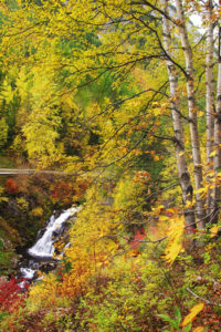
The Cranbrook Mountain 4-km approach road is vibrant with golden western larch in October.
Cranbrook/Kimberley Short and Easy Hikes
The sunlight turns crimson on the mountain peaks. The air is still. After resting during the heat of the day, birds become active again and animals venture into the open to feed. The lingering daylight of a warm summer evening offers the perfect setting for a short hike.
Get rid of those work shoes, put on some comfy runners and a jacket and get outside. You will be surprised how good it feels to unwind in the outdoors!
A variety of short and easy hikes are available around Cranbrook and Kimberley. All are within a 30-minute drive from town on paved roads and feature walks of only a couple of hours on established trails.
Cranbrook Kimberley Trail Maps
Cranbrook
For a trail map of the hiking and biking trails in the Cranbrook Community Forest, South Star Cross-country Ski Trails and other trails around Cranbrook, inquire at outdoor and bookstores in Cranbrook or see the author’s website: www.janicestrong.com
Kimberley
The Friends of the Kimberley Nature Park Society has produced a good map of the Kimberley trails, available in several Kimberley stores. Additional information about these trails is on the Friends of Kimberley Nature Park’s website, at http://kimberleynaturepark.rockies.net.
Directions
Road: any vehicle
In Cranbrook, on Highway 3/95, turn south on Victoria Avenue (a main intersection at the south end of Tamarack Mall). Victoria Avenue takes several bends, and as it leaves the city its name changes to Gold Creek Road.
0 km: Gold Creek Country Store, on the right side of Gold Creek Road.
1.3 km: Turn right (south) on 38th Avenue South.
4.3 km: Drive south on 38th Avenue for 3 km to the end of the road. Park by a gated and signed trailhead for South Starr Cross-country Ski and Hiking Trails (see entry #34E). Please don’t block the turnaround; park facing downhill, out of the way of the turnaround.

Janice Strong
Janice Strong is an established professional outdoor photographer. Her images grace collections all over the world and appear in many respected publications. She is passionate about hiking and is also an avid snowshoer and skier, exploring the outdoors of the East Kootenay in southeastern BC year round.She openly shares her passion for the outdoors with others and has introduced hundreds of people to the joys of hiking. For a decade she led hikes for the City of Cranbrook – Parks and Recreation. With her guidance, many people have themselves become enthusiastic hikers.
Climbing mountains, finding new places and enjoying the experience of the journey have always been important to Janice. She cherishes the little things she sees along the trail, as well as the grand destinations.
When Janice is not writing, hiking or taking photographs, she is involved in various creative digital, website design or photographic projects for her clients. She and her husband, Jamie Levine, enjoy their rural property, near Cranbrook, BC.