Distance

The road becomes a single-track trail 10 minutes farther up, just past a minor parking lot.
Within a couple of minutes the trail crosses a narrow stream, the first of several crossings of the same stream within the next 10 minutes.
There is a narrow trail to the right roughly 2 km, or 30 minutes, into this trek. Take a quick look to see a massive boulder pile. There is an alternative return loop from the lake that exits at this junction. Come back and carry on up the main path.
The path begins to climb and continues upward, but only for five to six minutes before plateauing again.
Seven to eight minutes after levelling, the trail splits left and right. There is no signage, and both trails are marked with green arrows. Make sure you take the left fork. On your return, however, if you wish to take a longer, alternative route through the aforementioned boulder field, take the right fork.
For the most part, the remaining 2 km from the fork is level and is only interrupted by two noteworthy landmarks. At 3 km a bridge crosses Creighton Creek, and about 10 minutes before you reach the lake there is a boggy area that must be navigated by balancing on logs, poles and rocks carefully placed in the bog over many years by many travellers.
The shoreline of the gorgeous Denison Lake is attained in 4 km, or just over an hour from the cattle guard.
Directions
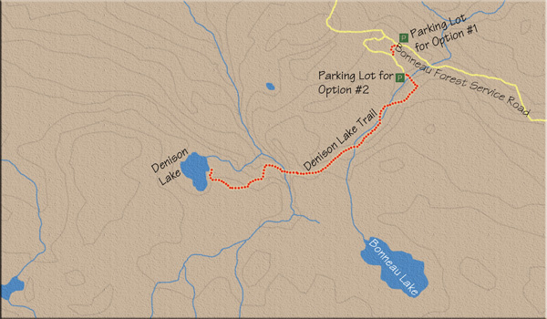
From the four-way stop in the hamlet of Lumby, drive east on Highway 6 for 1.7 km to Creighton Valley Rd., on the right (south) side of the highway. Travel Creighton Valley Rd. for 15.8 km to meet up with Bonneau Forest Service Rd. on the right. Creighton Valley Rd. becomes gravel at the 7.4 km mark.
There are two parking options at the trailhead:
1) From the base of Bonneau FSR, drive 6.9 km to an unmarked grassy parking zone on the right side of the road. The trailhead makes its way into the forest on the right side of the parking area, and within a couple short minutes the trail intersects with an inactive forestry road.
2) From the base of Bonneau FSR, drive 6.5 km to an inactive forestry road that shoots off from the right side of Bonneau FSR. This is the same road that the above trail meets up with. This road stretches for more than 1 km before hitting an abrupt end, so some hiking distance can be reduced by driving up it. However, it becomes rougher as it progresses. A high-clearance vehicle is recommended.inor parking lot.
Within a couple of minutes the trail crosses a narrow stream, the first of several crossings of the same stream within the next 10 minutes.
There is a narrow trail to the right roughly 2 km, or 30 minutes, into this trek. Take a quick look to see a massive boulder pile. There is an alternative return loop from the lake that exits at this junction. Come back and carry on up the main path.
The path begins to climb and continues upward, but only for five to six minutes before plateauing again.
Seven to eight minutes after levelling, the trail splits left and right. There is no signage, and both trails are marked with green arrows. Make sure you take the left fork. On your return, however, if you wish to take a longer, alternative route through the aforementioned boulder field, take the right fork.
For the most part, the remaining 2 km from the fork is level and is only interrupted by two noteworthy landmarks. At 3 km a bridge crosses Creighton Creek, and about 10 minutes before you reach the lake there is a boggy area that must be navigated by balancing on logs, poles and rocks carefully placed in the bog over many years by many travellers.
The shoreline of the gorgeous Denison Lake is attained in 4 km, or just over an hour from the cattle guard.