Distance
A massive storm in 2008 eliminated a large part of the trail to Diana Lake, causing “radical geographic changes,” said the owner of the Diana Lake Lodge. A slide ripped a canyon down a sidehill, about 18 m (60 ft.) deep in places. The canyon is too large to hike up and over, so a temporary trail is across the washout and it is unstable in places. The slide area will likely remain unstable for a many years.
North of the lake a 2-km trail leads through alpine meadows and by a tiny springs to a pass, at 2312 m (7,588 ft.), N39931-E53142. From the pass ascend an open ridge for another 1 km or so, and the views expose the whole Diana Lake valley.
Diana Lake Lodge
This private lodge is available for bookings (www.pinnaclemeadows.com). Guests expect a private getaway and deserve to be left alone. Please respect their privacy and do not hike around the vicinity of the buildings. The trail to the ridge has been rerouted to eliminate hikers around the lodge. The lodge is surrounded by meadows about half a kilometre from the shores of Diana Lake.

0 km: From the parking spot on Pinnacle Creek, cross the aluminum footbridge.
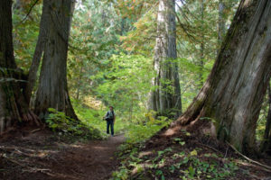
1.2 km: The trail leaves the road and turns right, up into the forest. The trail gains elevation moderately on the steep sidehill. A large, deep, washed-out canyon is rough to hike through; a temporary trail crosses it, but parts of it may still slide.
4.6 km: Trail leaves the forest and enters a large avalanche slope by the creek, then veers left up the main creek, heading northwest. The well-used trail crosses the tiny creek a couple times on small bridges, and as you climb the scenery is open alpine.
6.9 km: Diana Lake, N38534-E53924, at 2145 m (7,040 ft.).
Directions
Road: any vehicle
0 km: From Highway 95 drive about 18 km north of Radium. Turn east (right turn when driving from Radium) onto Kindersley Pinnacle FS Road, N22697-E57022.
5.2 km: Active water system with wooden flume along the right side road. Worth a stop to see. Stay to the main road (avoid a couple of logging branches).
7.1 km: Take left fork; road switchbacks. N24942-E63341.
7.9 km: Take right fork (8 km sign). Stay on main road.
8.5 km: Take left fork.
15.4 km: Take right fork (15 km sign) following Pinnacle Creek, heading northwest.
24.3 km: Parking lot beside creek, N35181-E54113.

Janice Strong
Janice Strong is an established professional outdoor photographer. Her images grace collections all over the world and appear in many respected publications. She is passionate about hiking and is also an avid snowshoer and skier, exploring the outdoors of the East Kootenay in southeastern BC year round.She openly shares her passion for the outdoors with others and has introduced hundreds of people to the joys of hiking. For a decade she led hikes for the City of Cranbrook – Parks and Recreation. With her guidance, many people have themselves become enthusiastic hikers.
Climbing mountains, finding new places and enjoying the experience of the journey have always been important to Janice. She cherishes the little things she sees along the trail, as well as the grand destinations.
When Janice is not writing, hiking or taking photographs, she is involved in various creative digital, website design or photographic projects for her clients. She and her husband, Jamie Levine, enjoy their rural property, near Cranbrook, BC.