
Distance
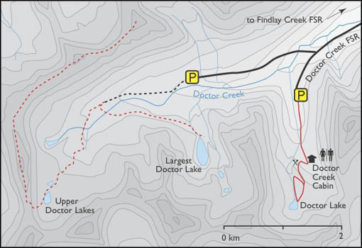
One of the cabins is tucked in a narrow deep basin surrounded by steep avalanche slopes. “Doctor Creek Cabin,” as a sign on the door says, has been restored for winter use and is managed by the Windermere Valley Snowmobile Society. The club has a snowmobile trail groomer and they keep the Doctor Creek trails and many others in good shape for winter riders. The club charges a fee for winter trail maintenance. Their cabin sleeps four to six and there are no dishes or supplies. The BC Forest Service co-manages this small backcountry cabin.
High above Doctor Creek Cabin and beyond the end of the mining road, an ATV track slices a route up to the lake and another ATV track makes a loop down by the creek to a second mining cabin in a subalpine meadow near the bubbling creek. The second cabin is an abandoned ruin.

0.0 km: From the parking spot continue hiking past the washout. Take the next three left forks. They are small and may be indistinct.
1.0 km: Take left fork for Doctor Creek Cabin, in 200 m. Backtrack the 200 m from the cabin to the junction and hike up the old road. The right fork at the switchback road leads up to a lake and an old mine tunnel site. Continue up the steep rocky road.
1.4 km: Gain 60 m (200 ft.) to the old mining tunnel. The tunnel entrance is fascinating, with two holes branching from the main gallery. Enter the tunnel at your own risk; the rocks are crumbling and the wooden ladder is unstable.
2 km: The left fork heads steeply up to the lake. The right fork is good for the way down, descending from the lake along the creek bank, with some loose rock.
2.7 km: Doctor Lake, N37722-E59314. To complete the loop, follow the trail by the outlet creek (north) downhill.
3.2 km: Ruined cabin and old mine works by creek.
3.6 km: Junction with mine road. Take the old road you hiked up on, back to the parking spot. Entire trip is 5.4 km.
Further explorations
Doctor High Tarn
The road to Doctor High Tarn and the largest Doctor Lake continues west past the 37 km on Doctor Creek Road turnoff for a couple more kilometres. There is parking for vehicles at N41915-E59260. The road eventually breaks down to an ATV track near the headwaters of Doctor Creek. The end of the ATV track is 2 km along the old roadbed, N41056-E55538. Please don’t drive an ATV beyond the end of the road, 2239 m (7,345 ft.).
Doctor High Tarn, N40088-E55108, at 2457 m (8,060 ft.), is a small tarn near the ridgeline in a high alpine basin. Reach the tarn by a moderately steep route up the centre of the valley, involving a short section of easy talus scrambling. From the high tarn, scramble steeply up to the ridge west for a nice ridgewalk northeast for a couple of kilometres toward Doctor Peak.
Largest Doctor Lake
The largest and deepest of the Upper Doctor Lakes, N40892-E57579, is a challenge to hike to, through thick forest and steep, cliff-like slopes. The lake is very scenic and remote and worth the effort, though.
At the beautiful largest Doctor Lake, we searched around for hours and had a hard time finding even a small camping spot somewhere on the steeply sloping sidehills of talus and dense forest. We ended up pitching our small backpacking tent on the edge of the waterfall at the lake outlet.
The tent was tipping down slightly to the tumbling water, but it was on a safe place. Although with the sound of the torrent right beside my head all night, I had various dreams of the tent sliding down the jagged rocks and into the water.
Directions
Road: any vehicle except for last 2 km, which may need high-clearance
On Highway 93/95, at 4.4 km north from the bridge over Kootenay River at Canal Flats, the turnoff is left (west) at the middle of a long hill.
0 km: Highway 93/95, turn left (west) off the highway, signed Blue Lake Forestry Centre, Findlay Creek FS Road. Climb out of the Columbia Valley on a good gravel road.
2 km: Continue straight.
4.4 km: Findlay Falls trailhead (see #16 Findlay Falls for hike). This BC Forest Service rec site, N54116-E81193 (just after 7 km sign), is a large flat spot for RV camping beside a busy logging road. No facilities.
5.3 km: Continue straight on Findlay FS Road (avoid the left turnoff, Skookumchuck Creek FS Road).
10.5 km: Continue straight (avoid the left turnoff, Findlay/Lavington).
12.8 km: Continue straight (past 15 km sign), staying on the main road (the turn to the right is for Blue Lake Forestry Centre or Whitetail Lake on Findlay-Whitetail FS Road).
18.0 km: Turn left (past 20 km sign) and immediately cross Findlay Creek Bridge onto Doctor Creek Road. Many logging roads branch off the main road and are signed with yellow markers with black letters reading Br B and Br D.
19.6 km: Take the left fork onto the main Doctor Creek Road (avoid right fork, which leads to logging).
22.0 km: Again take the left fork (24 km sign).
30.5 km: Continue straight, N44715-E62176. Don’t cross the big new bridge (right), signed Br D (just past 30 km sign).
33.4 km: “Travel Advisory” sign saying the road is not maintained beyond here, though the route was good in 2007.
37 km: For Doctor Creek Cabin, turn left onto a side road (38 km sign), N42449-E59565 (18 km along Doctor Creek FS Road). Stay straight on this road to access Doctor High Tarn and the largest Doctor Lake (see below).
38.1 km: Road washed out; park 1.1 km (south) from Doctor Creek Road, with a wide turnaround, N41915-E57624.

Janice Strong
Janice Strong is an established professional outdoor photographer. Her images grace collections all over the world and appear in many respected publications. She is passionate about hiking and is also an avid snowshoer and skier, exploring the outdoors of the East Kootenay in southeastern BC year round.She openly shares her passion for the outdoors with others and has introduced hundreds of people to the joys of hiking. For a decade she led hikes for the City of Cranbrook – Parks and Recreation. With her guidance, many people have themselves become enthusiastic hikers.
Climbing mountains, finding new places and enjoying the experience of the journey have always been important to Janice. She cherishes the little things she sees along the trail, as well as the grand destinations.
When Janice is not writing, hiking or taking photographs, she is involved in various creative digital, website design or photographic projects for her clients. She and her husband, Jamie Levine, enjoy their rural property, near Cranbrook, BC.


