Distance

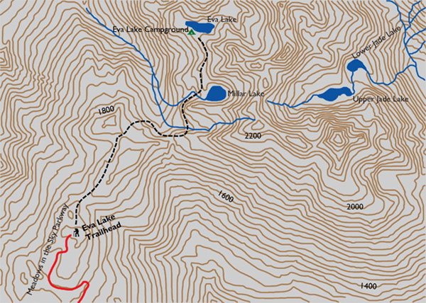
About an hour into the hike, with 4.8 km behind you, you’ll see a remnant of the imperial system of measurement in the form of a three-mile marker. Soon after, the previously flat, easy trail reminds you that you are in the mountains by presenting a short, five-minute burst of switchbacks. Signage at the summit of the switchbacks shows a branching of the route, to the right to Jade Lakes and left to Eva Lake. Fork and sign are at the 5.6-km mark, so only a quick 400-m stroll remains.
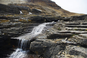
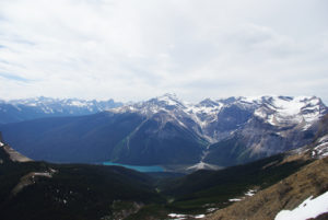
The level track to Eva Lake proceeds leftward, quickly crossing a wide open avalanche hill that reveals vistas of the Monashee Range. You then duck back into the forest, climbing slightly, just before reaching the lake and the campground. In the midst of this tranquil setting is an historic log cabin.
Eva Lake history
Eva Lake was discovered by Eva Hobbs in 1910 during a three-week camping trip to Balsam Lake with her two sisters and two other women. Hobbs had joined the newly formed Revelstoke Mountaineering Club the previous year, and during the women’s stay at Balsam Lake, five gentlemen from the club arrived to build a cabin at the lake. In exchange for a day’s labour and a cooked meal, the women asked the men to take a day to go exploring with them. As this large party crested a ridge, Hobbs was in the lead and was first to spot the undiscovered lake that would bear her name.
Hobbs was a schoolteacher in Revelstoke and became an avid hiker at the urging of the school principal, A.E. Miller, for whom nearby Miller Lake is named. Miller would have four or five of his teachers join his explorations into the Mount Revelstoke area, and many would climb to the summit with him long before a trail was cut. One of his first companions on those hikes was C.R. Macdonald, the local druggist, for whom Macdonald’s Bluff, on Mount Revelstoke, is named.
Construction of the route to the summit of Mount Revelstoke was completed in 1908, by the hard work and perseverance of local residents. The network of trails to the various lakes would take many more years to finish, as the exploration of this mountain was quite gradual compared to the rapid growth of mountaineering in nearby Glacier National Park. Citizens lobbied provincial and federal governments to get Mount Revelstoke declared a national park, and in 1914 their efforts succeeded. During the push for a park, the locals also convinced the governments to pave the route they had broken to the summit. The Meadows in the Sky Parkway took 16 years to finish, becoming complete in 1927. The reason for the name of the parkway is evident, with an abundance of wildflowers in the alpine region of the mountain. This truly is a wondrous place to hike. owers in the alpine region of the mountain. This truly is a wondrous place to hike.e to hike.
Directions
The Meadows in the Sky Parkway is found just outside of the eastern edge of the township of Revelstoke, BC. Follow the signage to the Mount Revelstoke National Park kiosk, pay the fee and proceed upward on the parkway. The trailhead is beyond the parking lot, and there is a free shuttle bus that takes tourists up the final 2 km of pavement (or you can walk). The trailhead is at the northeast end of the bus turnaround.
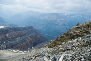
The path begins a slight decline almost immediately, and the spectacular benefits of beginning a hike so far up begin to pay off just as quickly, as the views begin right away.
The temporary descent ends within 500 m, where the forest becomes thinner. An interpretive sign reminds travellers that they are in bear country and presents logical tips for avoiding encounters. An open hillside of low brush and wildflowers is the first in a succession of pockets of beautiful rolling meadows lasting for about a kilometre.

Gerry Shea
“Gerry Shea moved to Kamloops from Vancouver at the age of nine, which is when he became enchanted by the nearby hills. It was on a family vacation many years later that he discovered the mountains and began hiking and climbing in his spare time, gathering knowledge and experience that he has since used to help beginning hikers, scramblers and backpackers to trek safely. Gerry lives in Kamloops with his wife and children.”Excerpt From: Gerry Shea. “The Aspiring Hiker’s Guide 2: Mountain Treks in British Columbia.” iBooks.