Distance
The Fairy Creek trail is a peacefully satisfying hike though a forest of old cottonwoods, aspens, cedars and fir trees that shelter the easy hiking trail. Snails in shells along with dense undergrowth of thimbleberry, mosses and ferns are along the soft earth path. Cedar stumps remain in the narrow valley from logging in 1910–13 and from harvesting again in the 1930s.
This is a great hike in the autumn, from mid-September until the middle of October, when the deciduous trees and bushes shimmer in their amber and red attire. It is also a good rainy-day hike, for the mosses and leaves shine with water, emphasizing their colour. Throughout spring (May and June) enjoy the blooming of many flower species. Also in spring, the high country snowpack is melting and water tumbles and hisses off the massive inclines of Mount Fernie, creating waterfalls from the numerous cliff faces.
As the trail gains elevation, the forest and bush thin, exposing steep slopes of rock and sheer cliffs at the base of Mount Fernie to the left (west, across the creek) and at the base of Mount Proctor to the right (east). Light-grey stacked limestone layers tower hundreds of metres above the deep Fairy Creek valley, with its streams of waterfalls softening the abrupt gullies.

Posted along the trail is a sign reading: “The Trail Crosses Private Property – Please respect the privilege – Use at your own risk.”
0 km: BC Tourist Information Centre/Fernie Chamber of Commerce parking lot. Trail heads into the bush on the east side of the building and angles steeply upward.
600 m: When the trail intersects an old dirt road, turn left. Follow the road uphill through a grassy meadow (ignore a small road that intersects from the left, downhill of the main trail/road; it formerly was the trail). Cross the fence and take the small trail uphill on the left.
750 m: The trail continues uphill and, in less than 100 m, intersects another road. Again turn left. Hike west on the wide trail through a lush forest of aspen, poplar and fir.
1.5 km: Just after the second gate, take the right fork. The trail heads steeply upward to the falls and the base of the mountains. (Avoid the left fork, the wide forest road you were following; it just continues along Fairy Creek.) For the next 400 m the trail gains 76 m (250 ft.), and then levels off again.
2 km: Welcoming rest spot at a picnic table, N88301-E39463, at 1120 m (3,670 ft.). This is the junction to the Fairy Creek Falls viewpoint trail. The table may be hidden in the bush above the trail. If, within 50 m or less the trail crosses a creek in a narrow steep gully, you have gone too far. Backtrack and look uphill for the picnic table, or look downhill to a steep, narrow side trail heading toward the creek.
2.1 km: A falls view trail descends 30 m (100 ft.) from the main trail, but this is the best view of the tiny waterfalls. Climb back up to the main trail and continue northwest to the end of the Fairy Creek valley.
4 km to 7 km: The forest opens out into thickets of 3-m-tall alder bushes. The lower slopes of Mount Fernie rise on the left. Good trail to here and the trail steepens and eventually peters out.
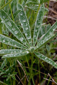
Fairy Creek Falls in mid-September, with a diversity of plant species, most in autumn colours.
Hartley Lake and Dicken Road
Road access for hikes:
Ghostrider–Mount Hosmer
Three Sisters Mountain
Mountain Lakes Trail (Three Sisters Mountain to Island Lake Resort)
Map: 82G/11 Fernie (NAD27)
Road map: see Fernie road map
Road: high-clearance vehicle
Drive
On Highway 3 from the BC Tourist Information Centre in Fernie, Dicken Road is the paved sideroad parallel to the highway. Dicken Road loops back onto the highway again in 4.1 km northeast.
0 km: From north Elk River Bridge in Fernie, head toward Sparwood on Highway 3.
800 m: BC Tourist Information Centre; continue on the highway.
5.1 km: Turn left (north) onto Dicken Road (northeast end).
5.6 km: In 500 m from the highway turn right (north) onto Hartley Lake Road; entrance is obscure but signed.
Reset odometer to 0.
Hartley Lake Road is steep and often muddy. A 4x4 is preferred for traction on the steep grade, but high-clearance is not required.
0 km: Hartley Lake Road junction with Dicken Road, N90400-E43300. Stay on the main road (barely one lane), smaller roads branch.
6.6 km: Trailhead and parking for Ghost Rider on Mount Hosmer, unsigned, well-worn trail to the right (east) side into the bush at a wide pullout on a left curve, N95907-E47349, at 1443 m (4,730 ft.). (There are several similar left curves along here, but only one has a well-used trail to the right.)
8 km: Continue on Hartley Lake Road for Three Sisters Mountain. (Avoid the fork downhill on left; it is the access to Hartley Lake).
8.5 km: Stay on main road (avoid small road on left, which is an old trail to Three Sisters).
10.6 km: Turn left (west) off Hartley Lake Road onto a prominent dirt road for the Three Sisters turnoff (at 7 km sign), N98894-E39167. Hartley Lake Road continues past the trailhead turnoff and on to the Sulphur Creek/Bull River roads. After leaving Hartley Lake Road, drive southwest for 100 m to a large field, where there is good parking for low-clearance vehicles. The remaining road is rocky with deep mudholes, but the grade is not steep. There is a weird steel bridge that you must align your tires with exactly or your vehicle will slip into the tiny creek. Drive 3.1 km to the wide turnaround at the trailhead.
13.7 km: Trailhead for Three Sisters, N97100-E37400.
Road: any vehicle; Highway 3
Directions
Drive
On Highway 3 from the BC Tourist Information Centre in Fernie, Dicken Road is the paved sideroad parallel to the highway. Dicken Road loops back onto the highway again in 4.1 km northeast.
0 km: From north Elk River Bridge in Fernie, head toward Sparwood on Highway 3.
800 m: BC Tourist Information Centre; continue on the highway.
5.1 km: Turn left (north) onto Dicken Road (northeast end).
5.6 km: In 500 m from the highway turn right (north) onto Hartley Lake Road; entrance is obscure but signed.
Reset odometer to 0.
Hartley Lake Road is steep and often muddy. A 4x4 is preferred for traction on the steep grade, but high-clearance is not required.
0 km: Hartley Lake Road junction with Dicken Road, N90400-E43300. Stay on the main road (barely one lane), smaller roads branch.
6.6 km: Trailhead and parking for Ghost Rider on Mount Hosmer, unsigned, well-worn trail to the right (east) side into the bush at a wide pullout on a left curve, N95907-E47349, at 1443 m (4,730 ft.). (There are several similar left curves along here, but only one has a well-used trail to the right.)
8 km: Continue on Hartley Lake Road for Three Sisters Mountain. (Avoid the fork downhill on left; it is the access to Hartley Lake).
8.5 km: Stay on main road (avoid small road on left, which is an old trail to Three Sisters).
10.6 km: Turn left (west) off Hartley Lake Road onto a prominent dirt road for the Three Sisters turnoff (at 7 km sign), N98894-E39167. Hartley Lake Road continues past the trailhead turnoff and on to the Sulphur Creek/Bull River roads. After leaving Hartley Lake Road, drive southwest for 100 m to a large field, where there is good parking for low-clearance vehicles. The remaining road is rocky with deep mudholes, but the grade is not steep. There is a weird steel bridge that you must align your tires with exactly or your vehicle will slip into the tiny creek. Drive 3.1 km to the wide turnaround at the trailhead.
13.7 km: Trailhead for Three Sisters, N97100-E37400.

Janice Strong
Janice Strong is an established professional outdoor photographer. Her images grace collections all over the world and appear in many respected publications. She is passionate about hiking and is also an avid snowshoer and skier, exploring the outdoors of the East Kootenay in southeastern BC year round.She openly shares her passion for the outdoors with others and has introduced hundreds of people to the joys of hiking. For a decade she led hikes for the City of Cranbrook – Parks and Recreation. With her guidance, many people have themselves become enthusiastic hikers.
Climbing mountains, finding new places and enjoying the experience of the journey have always been important to Janice. She cherishes the little things she sees along the trail, as well as the grand destinations.
When Janice is not writing, hiking or taking photographs, she is involved in various creative digital, website design or photographic projects for her clients. She and her husband, Jamie Levine, enjoy their rural property, near Cranbrook, BC.