Distance
From Fay’s Lake you can hike through an open alpine basin and by tiny creeks to a spacious alpine ridge that is only 150 m (500 ft.) higher.
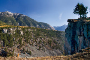
The best reason to backpack to Fay’s Lake is the marvellous alpine hike you can do the next day. The wilderness route goes around the remote high country of Diorite Creek and up a ridge to the summit of Teepee Mountain.
We camped in an alpine basin tucked deep in the Rocky Mountains. During one visit, thunderstorms rumbled in the distance all afternoon and as we approached the tarn the rain began. At the campsite, the remains of a tree that had been exploded into slivers by lightning lay in the deep valley, far from the mountaintops and ridges. It unnerved us to see such a large tree so low in the valley destroyed by lightning.
Our small group rushed to set up tents before the inevitable downpour began, and just in time. The storm hit with such power that lightning and thunder walloped simultaneously and continued strike after strike for almost an hour.
The meadow we camped in flooded in several places and one lightning strike started a rockslide not far above us. Among the concealing clouds, we could only hear its threatening sound somewhere above us and nearby our camp. All we could do was wait and listen. Eventually the stones stopped clattering, but still the storm raged around us. The deafening roar of wind collapsed and ballooned our flimsy shelters until finally the storm blew over and the valley returned to quiet. I have camped at Fay’s Lake many times and the storms there seem to be more extreme than many other places.
Afterward, while drying our parkas by the fire, we discussed the storm and felt the bond of our friendships grow stronger.

You should be familiar with mountain routefinding and have excellent topographical map-reading skills. Although most of the hike is on a forested trail, there are some confusing sections.
0 km: Begin the hike from the large ATV parking spot at the Nicol Creek clear-cut, N20810-E06531, at 2030 m (6,660 ft.). The trail is in fair condition.
800 m: Look for a faint trail branching off to the right, heading uphill and north, N20607-E05930. If you didn’t see the trail junction, either route will get you there.
1 km: The left fork reaches the ruins of an old cabin in a lush meadow, N20450-E05789. Stay on the trail, climbing through thinning subalpine vegetation to Fay’s Lake.
2.1 km: Fay’s Lake, N20625-E05192, at 2340 m (7,680 ft.). Without an ATV assist, you could still hike the extra 8.1 km, gaining an extra 500 m (1,700 ft.) elevation and descending 180 m (600 ft.) to the creek in a day hike, but you may want to camp at Fay’s Lake, as it’s a long hike to get there.
Further explorations
Fay’s Lake to Teepee Mountain
Rating: moderate
Time: full day return to Fay’s Lake
Distance: about 6 km one way
The trail is subalpine; routefinding and map skills are advised. The ascent route to the summit of Teepee Mountain is on shale and rock.
From Fay’s Lake, hike west over smooth alpine meadows to the pass above Fay’s Lake. Descend steeply to a small tarn. From the tarn, hike on-contour (don’t descend or climb) as you navigate around the south headwaters of Diorite Creek. Far below you is Diorite Lake. Hug the spacious alpine talus along the southwestern edge of the valley. Turn west and head up the first major side tributary into alpine meadows. Continue to follow the sidehill around to the north about 1 km and make your way up an eastern side ridge of Teepee Mountain. You may have to explore to find the way. The route is moderately steep, as it gains 420 m (1,400 ft.).
Directions
Road: high-clearance vehicle; off-road ATV assist
Follow detailed directions for Wild Horse Creek Road.
0 km: Junction of Wild Horse Creek Road and Wardner/Fort Steele Road.
26.8 km: Major washout on Wild Horse Creek Road; end of the truck road. Take a very rough ATV route around this obstacle, or turn at the Nine Basins road and make a big detour to get back onto Wild Horse Creek Road, on a well-used track. Stay on the main Wild Horse Creek Road to the pass with Nicol Creek.
29 km: Wild Horse/Nicol Pass 1847 m (6,060 ft.), N20800-E08800. From the pass the road is very rough as it heads downhill and it is well used.
30 km: Take the left fork at junction in an old logging block and head downhill to cross the creek in 1.2 km. The crossing may be difficult in early July or in high water. Follow the main ATV track north up into the old clear-cut. Follow the track up around a switchback and turn right, uphill. At the second switchback, (1 km from creek crossing), N20860-E07198, continue climbing up the steep logging cutblock and around two more switchbacks. Drive another 700 m past the highest (fourth) switchback on the ATV track.
34.3 km: ATV parking in a large level spot, N20810-E06531, at 2030 m (6,660 ft.).

Janice Strong
Janice Strong is an established professional outdoor photographer. Her images grace collections all over the world and appear in many respected publications. She is passionate about hiking and is also an avid snowshoer and skier, exploring the outdoors of the East Kootenay in southeastern BC year round.She openly shares her passion for the outdoors with others and has introduced hundreds of people to the joys of hiking. For a decade she led hikes for the City of Cranbrook – Parks and Recreation. With her guidance, many people have themselves become enthusiastic hikers.
Climbing mountains, finding new places and enjoying the experience of the journey have always been important to Janice. She cherishes the little things she sees along the trail, as well as the grand destinations.
When Janice is not writing, hiking or taking photographs, she is involved in various creative digital, website design or photographic projects for her clients. She and her husband, Jamie Levine, enjoy their rural property, near Cranbrook, BC.