Distance
Pick up a free map of Fernie Alpine Resort featuring summer hiking and biking trails. Their website has a resort map: www.skifernie.com.
Fernie Alpine Resort operates their chair lifts in summer and both routes ride at least some of the distance on the lift. A fee is charged for the chair lift rides. The lifts operate from 10:00 a.m. to 5:00 p.m. during summer, but you may want an earlier start than 10 a.m. to complete the long hike and be back by 5 p.m. for the ride down.
Geology
The rocks were brought to life for me by hiking with two professional geologists. We examined fossilized corals, petrified crinoid stems (which are fossilized relatives of the starfish) and hard, knobby, silica rocks that protrude from the limestone, called chert nodules. The layers here are on edge and have actually bent back on themselves, leaving the older marine Palliser formation of limestone sitting atop the younger Fernie shale. Venturing uphill you go backward in geological time.
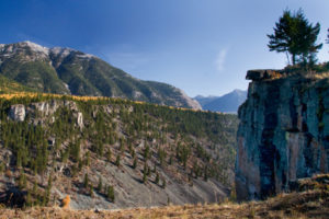
The mountains of the Lizard Range of the Rockies near Fernie consist of crumpled light-grey blocks and massive layers of limestone that were forced upward, and today the ends of those layers rise in sheer, cliff-like steps. (The rock steps are like a stack of books that was tipped over and then one corner of the stack was lifted up.) Hiking the ends of these bedding layers gives the impression of ascending up the edges of that stack of books.
Planning the hike
Plan your hike when the weather is dry, because narrow sections of this ridge are slippery when the clay soil is wet.
Summer thunderstorms are common and there are only a few routes to get off the ridge. Bring extra clothing in your pack, as cold breezes scour the barren summits even on the hottest summer days.
There is no surface water for drinking along this hike, so carry at least two or three litres with you.
The resort is trying to prevent conflicts between cyclists and hikers by asking hikers to stay higher than the chairlifts and cyclists to ride lower than the top of the lifts. The caution noted on the map should be emphasized: “Do not walk on black diamond bike trails; cyclists whiz down very fast.”
Ridgewalk trails are not suitable for dogs.
There are two ways to do this hike. Both involve some steep scrambling and balancing along rocky steps. They are not technical climbs, but it is challenging terrain.
One way is the shorter ridgewalk, which is not as exposed nor as ambitious as the as the second way, which is to hike the challenging entire loop.
Shorter ridgewalk: Polar Peak
The first option is to ride the chairlift both ways and hike up only the southern section of the ridge to Polar Peak. It still gives you the ridgewalk experience but it eliminates most of the challenging terrain and exposure. Besides being easier, this first way is much shorter, about four to six hours.
The shorter ridgewalk starts at the top of the Timber Chair (opening time is 10 a.m.) and follows a circular route. Start at Lost Boys Café and head toward Lost Boys Pass. Follow signs up to and along the ridge and over Elephant Head summit, 2045 m (6,709 ft.). A cable is installed along a narrow section. Hike along the ridge to Polar Peak. Follow the signs. Backtrack along the ridge and descend a ridge between two ski bowls. Hike back to the Timber chairlift for your ride back down. Do not continue northwest beyond Polar Peak, as the route is narrow and Snake Ridge is a difficult descent.
Entire loop
The second option, the full ridgewalk loop, is a long day hike of about six to eight hours. The route has sections of steep, blocky and hazardous scrambling, with some loose rock and very narrow exposed mountain passes. Climb several summits along the ridgewalk. After a satisfying day hike, ride the chairlift down from Timber Bowl. Of course, if you still feel like it, you can hike all the way down, as well. Watch for downhill cyclists, and stay off routes marked for cyclists.
Cables may be installed in places along the route for safety, but normal weathering and other hazards may have reduced their security. Check their condition before counting on them, as this route is not maintained, and, as with all trails in the mountains, use this route at your own risk.
Lizard Range full loop
Rating: difficult/long
Time: full day hike
Distance: 11.1 km full loop
Elevation gain: 1074 m (3,524 ft.) plus another 365 (1,200 ft.) for gains and losses along the six summits of the ridge
Grizzly Peak: 2103 m (6,900 ft.)
Polar Bear Peak: 2134 m (7,000 ft.)
Trail: rough route to alpine ridge; scrambling; exposed narrow ridges; cables across exposed sections; trail not suitable for dogs.
Shorter ridgewalk: Polar Peak
Rating: moderate
Time: short day hike
Distance: 3 km one way
Elevation gain: 340 m (1,125 ft.)
Trail: steep limestone; well-marked; narrow ridge; cable down one slope; trail not suitable for dogs.
Map: 82G/6 Elko (NAD27)

Phone the resort for ski-lift operation schedules and pick up trail map of the resort.
0 km: Park at the day-use area of the Fernie Alpine Resort. Follow the ski hill road up the north side of the ski runs (climbers’ right side). Start under the Deer chair and head up the main wide slope on the summer road. The road is less steep than heading straight up, but it is longer. Climb to the top of the Boomerang triple chair and continue climbing to the top of the Great Bear Express quad. Gain 640 m (2,100 ft.).
4.3 km: From the top of the Great Bear Express quad chairlift, hike northwest (right) across the top of the Cedar Bowl.
5.1 km: Reach a steep spur ridge, known as Snake Ridge. Look upward to your right for the start of the trail along the ridge, as the cat track swings downhill. This ridge heads southwest and intersects the main summit of Lizard Ridge at a right angle. Climb the route marked with red dots painted on the rocks. The route is very steep scrambling and it gains another 360 m (1,200 ft.) from the chairlift to the ridge. The upper sections of Snake Ridge are mixed between easy sections of trail interrupted by steep rocky scrambles. You need to search around for good handholds. This is the hardest part of the circuit hike.
6 km: Crest the rim of this fractured spur ridge, N80966-E35720, and finally enjoy level footing as you step up onto the smooth alpine terrain of Lizard Ridge. Turn left and follow the red dots south, then southeast along this alpine ridge.
6.8 km: The first summit is Grizzly Peak at 2103 m (6,900 ft.). The ridge narrows to about 45 cm, between Grizzly and Polar Bear peaks. Cross this narrow but short section carefully, as it drops off severely on both sides. A cable is installed for extra safety. Gain and lose about 60 m (200 ft.) several times as you hike between the various peaks along the ridge.
8.2 km: The rounded top of Polar Peak 2134 m (7,000 ft.). Pass the Elephant Head summit.
9.5 km: Continue southeast along the ridge. You may scramble down the stable scree on a spur ridge into Currie Bowl, N78190-E36774, and hike down to the ski runs on your left (north) in Lizard Bowl.
10.5 km: For a longer trip, stay on the more travelled trail along the ridge. Cross the top of Currie Bowl. Follow the ridge up and down over predominantly broken limestone and the steep descent into Lost Boys Pass. Descend down the middle of Timber Bowl.
11.1 km: Ride on the Timber chair back down to the resort, N77800-E37700. If hiking down, the safest descent route is to follow Megasaurus over to Lizard Bowl and follow it all the way down to resort. This is designated as a blue run, but still watch for cyclists. If you are walking down, descend 730 m (2,400 ft.) (in 2.5 km straight-line distance). (Trail research by DH and GW.)
Directions
Road: any vehicle
Take Highway 3 for 4.5 km south of Fernie. Follow the signs to Fernie Alpine Resort. Park in the ski resort day parking lot.

Janice Strong
Janice Strong is an established professional outdoor photographer. Her images grace collections all over the world and appear in many respected publications. She is passionate about hiking and is also an avid snowshoer and skier, exploring the outdoors of the East Kootenay in southeastern BC year round.She openly shares her passion for the outdoors with others and has introduced hundreds of people to the joys of hiking. For a decade she led hikes for the City of Cranbrook – Parks and Recreation. With her guidance, many people have themselves become enthusiastic hikers.
Climbing mountains, finding new places and enjoying the experience of the journey have always been important to Janice. She cherishes the little things she sees along the trail, as well as the grand destinations.
When Janice is not writing, hiking or taking photographs, she is involved in various creative digital, website design or photographic projects for her clients. She and her husband, Jamie Levine, enjoy their rural property, near Cranbrook, BC.