Distance
The devastating forest fire season of 2003 left much of northern Kootenay National Park inaccessible, with some parts completely closed to public hiking. Fortunately, on July 16, 2005, the Floe Lake Trail was reopened. Although fallen burnt timber has been cleared, it is a good idea to follow Parks Canada’s recommendations for travelling in a post-forest-fire forest:
Don’t go in windy conditions, especially with rainfall or snow.
Travel quickly to reduce exposure time.
Stop only in open, flat areas, keeping at least the distance of a tree’s height between you and the nearest tree.
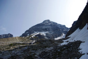
Nonetheless, the trek through the burn adds a unique appeal to an already distinct hike. Pack light, as the last 2.5 km is a 300- to 400-m climb without a level break. Floe Lake is the beginning of one end of the “Rockwall Trail,” which extends for more than 40 km beneath the east edge of The Rockwall. The Rockwall itself is a ridge of Ottertail limestone several hundred metres high and 31 km long, culminating to the north at Mount Drysdale.

One of my favourite features of Kootenay Park, setting it aside from other regions of the Rockies, is the wide, steep avalanche slopes that seem to appear without notice. Allowing spectacular scenery even in dense forest, these slopes suddenly open to present stunning unexpected views across valleys and mountainsides. Such slopes are numerous throughout this spectacular trek.
Five minutes after exiting the Floe Creek crossing, the familiar feeling of a gradual climb transforming into switchbacks becomes evident and eventually develops into the dominant theme. Twenty minutes later the trail levels off and Floe Creek is so distant below to your left that you barely hear it anymore.
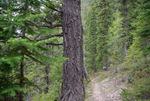
The hike continues through the severely fire-damaged forest of spruce and lodgepole pine. It is astonishing to witness this natural devastation, but even more astonishing to observe the forest regenerating itself. Saplings are beginning to grow, and much of the undergrowth and grasses have returned in an unstoppable resolve to flourish. This is a marvellous, unique experience. Do not hesitate to stop and look; this all a part of your journey.
Over the next hour and a quarter, the trek is rather uneventful as it rambles through the forest, interrupted by great slopes, stream crossings and some minor rises until reaching the 8-km mark. It is at this spot that the trail takes a steep uphill turn, zigzagging precipitously upward to gain 300 to 400 m within 2.5 km. As these gruelling switchbacks begin, mature forest resumes and the viewing becomes limited, though there are a few spots along the way that allow you to look back across the valley. But you are going to be too tired and sore anyway to even turn around and look. So, head to the ground and keep trudging. At times like this, I find that solving math problems in my head distracts me from the obvious toil. I suggest you too try something to occupy your mind.
Just as you reach the summit of this climb, thoroughly exhausted, the magnificent Rockwall comes into full view. Stop for a moment to catch your breath and focus on the goal. The campground is only another 500 m farther, and the hike graciously levels off ten minutes before you reach the lake.
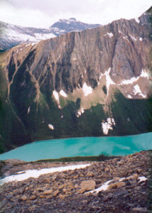
Indeed, Floe Lake is another treasure offered to us by the Rocky Mountains, being surrounded by meadow, mountain, forest and ice. The far shore of the lake is enclosed by cliffs and glaciers, while the sides are lined with subalpine fir and small alpine meadows. The lake’s name comes from small icebergs that calve into the lake from the glacier that feeds it at the far end. Just the sight of such dazzling beauty renders the steep climb of moments past nothing less than petty.
Directions
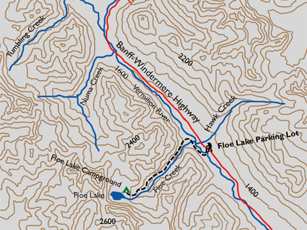
From the Castle Junction interchange, proceed south onto Hwy. 93. The parking area is located 32 km south of the Castle Mountain Junction on the west (right-hand) side of the highway.

Gerry Shea
“Gerry Shea moved to Kamloops from Vancouver at the age of nine, which is when he became enchanted by the nearby hills. It was on a family vacation many years later that he discovered the mountains and began hiking and climbing in his spare time, gathering knowledge and experience that he has since used to help beginning hikers, scramblers and backpackers to trek safely. Gerry lives in Kamloops with his wife and children.”Excerpt From: Gerry Shea. “The Aspiring Hiker’s Guide 2: Mountain Treks in British Columbia.” iBooks.