Distance
The wide trail does not offer much viewing through the trees, but it is only a little more than 6 km of level hiking to the campground. The trail continues to Fortress Lake, but going there is not recommended unless you expect to get awfully wet. Crossing the Chaba River requires fording cold water that is one-half to two metres deep. Even in low-water season there is still a very dangerous risk of being swept away in the strong current.
Day tripping to the Athabasca Crossing Campground and the Athabasca River bridge will take most of a day, as they are 8.8 and 9.3 km up the trail respectively.

Another 15 minutes gets you across a small stream. The level, uneventful, well-trodden path reaches through the beautiful coniferous forest, and soon enough the 6 km is complete as the spectacular sight of the big bend in the Athabasca River comes into full view. As the forest opens up at Big Bend the most prominent sight is Mount Quincy standing directly south 16.5 km away. Because of the flat walk-in, the work is done in 75 to 90 minutes, allowing hikers to pack in a few extra luxuries. These peaceful, tranquil, rapid waters can quickly calm even the most bad-tempered individuals. The waters here move slow enough to become entrancing, yet just fast enough to make pre-whitewater bubbling sounds, thus momentarily breaking the enchanting trance.
Day hiking the trail is much like the first 6 km except that there is a mild rise in elevation immediately after leaving Big Bend Campground. One to two kilometres later the trail loses the elevation gained and drops down to the Athabasca River. Then, just as quickly, it regains the forest. The rest of the hike is straightforward by simply following the main trail. There are no key intersections or diversions. The Athabasca River bridge is a wondrous destination, since it has few lingering visitors, leaving it for your sole enjoyment. Quiet contemplation on this structure makes this long day trip meaningful.
History
Like many natural landmarks in the Rockies, Fortress Lake was discovered during a quest for something else. Arthur Philemon Coleman, a professor of geology from the University of Toronto, his brother, L. Quincy Coleman, a rancher from Morley, Alberta, and L.B. Stewart, also a professor from the University of Toronto, all set out in the summer of 1893 to find and climb the tallest mountains in North America. There was a legend floating around that Mounts Hooker and Brown were both between 15,000 and 17,000 feet above sea level.
This written report had come 66 years earlier from the Scottish botanist David Douglas after he travelled through Athabasca Pass in 1827. Douglas named the peaks on this voyage. The Colemans and Stewart would eventually discover that these mountains came up well short of their celebrated status, with Mount Brown a mere 9,184 feet and Hooker only slightly taller at 10,781 feet. In fact, it was Douglas who recorded the first ascent of Mount Brown in 1827 and declared he had accomplished this feat in an afternoon. So, it is still a bit of a mystery why he claimed it to be 17,000 feet high. Mount Hooker was conquered almost a century later, in 1924, by Conrad Kain, J. Monroe Thorington, Alfred J. Ostheimer and M.M. Strumia.
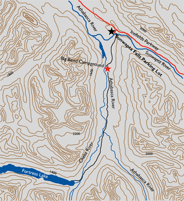
During the mountain finding mission the threesome named a mountain that was like a great buttress, calling it Fortress Mountain. The pass and lake take their names from the mountain. A.P. Coleman also gave the Chaba River its name, as he noticed while following this stream that there were countless beaver dams in the river, as well as trees cut down by beaver alongside the river. “Chaba” comes from the Stoney Indian word for beaver. Fortress Lake was not visited until four years later, by Walter Wilcox and Robert L. Barrett. Mary Schäffer also took an exploration party to this beautiful lake in 1907.
Directions
From the intersection of Highway 16 and the Icefields Parkway travel 53.5 km south to the Sunwapta Falls parking lot. Look for the throng of tourists making their way to and from the Sunwapta Falls viewpoint bridge. Break trail through the cameras to arrive, hopefully unscathed, at the far end of the short bridge. Actually, the falls are quite spectacular, justifying the heavy traffic. Stop and take a look yourself.