Distance
By taking a GPS waypoint atop a Geodetic Survey of Canada marker on the higher of the two peaks, I was able to work with Steve Irwin and Patrice Lascelles of the NRCan in identifying one of the nameless peaks. Actually, Steve and Patrice did all the work, since I simply forwarded the coordinates to them. They have identified the peak as “GSC marker 696005 on the low south tip of Mount Cory in the Sawback Range.” Many thanks to Steve and Patrice for their hard work, which produced results for me within a day.

Once on the trail, you will encounter the most difficult part of the climb within five to ten minutes. In fact, the lateral exposure of the ridge will be in sight within a few moments of turning onto the trail. By taking the best of the many routes available, you can attain the ridge crest within another 10 minutes of moderate scrambling up the side of the ridge. Up on the ridge, cairns and the path come into plain sight.
The only obstacle on the climb is a rock abutment which is reached in about 10 minutes more and is easily circumnavigated by following the track around the bluff into the bushes on the right side. The entire excursion is well marked with cairns and a well-used path, suggesting that either many other scramblers have also lost their way to Mount Cory, or, unlike me, they knew where they were going.
Continue this course until you reach the saddle of the two peaks. As you gaze up at the two peaks, the right one appears to be the highest, but in fact the one on the left (west) is higher by 5 m. The Geological Survey of Canada marker is unmistakable once you’ve reached the summit. It is a large wooden pyramid filled with rocks straddling the marker, which is firmly secured to the ground in concrete.
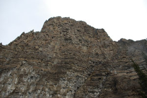
Views from this vantage point include Mount Cory directly behind to the north, with the best possible view of the Hole in the Wall. The Hole in the Wall is a dark, yawning cave extending almost 30 m into the southwestern slope of Mount Cory. The Sundance Range is 6.5 km to the southeast (true bearing 156°), and the unmistakable limestone slab of Mount Rundle sits 14.3 km into the horizon almost due east at a true bearing of 100°.
History
The Sawback Range extends south to the Bow River just northwest of the town of Banff, reaching as far north as Bonnet Peak. Other peaks in this range include Mount Cory, Block Mountain, Mount Ishbel, Oyster Peak, Cockscomb Mountain, Mount Louis, Mount Fifi, Mount Edith and The Finger. The range was named on August 17, 1858, by Sir James Hector (1834–1907), a surgeon and geologist with the Palliser Expedition.
Soon after reaching the Rockies, John Palliser had sent Hector to investigate the geology of the Rocky Mountains. He left present-day Morley, Alberta, on August 11 with the hope of discovering the source of the Bow and a possible pass as a trading route to the Columbia River. Coincidentally, Hector left the same day as Eugène Bourgeau, a botanist with the Palliser Expedition, and the parties travelled together for a day exploring Grotto Mountain. Bourgeau decided to stay near present-day Banff to collect samples of the local plant life, while Hector continued his way over Grotto Mountain to a vast valley where he spent several days collecting fossils, exploring the nearby slopes and allowing time for his party to collect meat for the upcoming adventure.
Finally, on August 17, after spending the previous day arduously exploring Cascade Mountain, Hector set his sights on his objective. Following a map drawn by a Stoney Indian guide Hector named “Nimrod” because he could not pronounce the man’s Indian name, the route took them on a long, roundabout track that would eventually bring them to Castle Mountain. The vertical beds of grey limestone that form the serrated peaks of the range present such a jagged appearance that they reminded Hector of a saw, hence the name.
Directions
From the west entrance into Banff townsite, travel west for 5.6 km to the Bow Valley Parkway turnoff. At 2 km along this route there is an unmarked turnoff on the right side of the road. This is the trailhead.