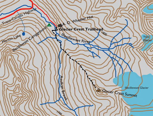
Distance

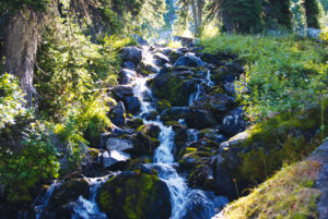
There is a slight incline in the forest that quickly settles into a wide, flat path for about 500 m. A high bridge rises above Asulkan Brook, which marks the 1.2-km point of the trek. The hike pushes upward from the brook, and within a couple of short minutes a fork in the trail is accompanied by a sign pointing you to the left, marking 3.5 km remaining on this hike.
The next hour and a half or so is a climb of switchbacks through an increasingly thinning forest that allows the occasional view of Abbott Ridge, Mount Abbott and the Asulkan Ridge. The trail is surrounded by a variety of ferns, mosses, liverworts and broad-leafed shrubs. During the seemingly endless switchbacks, watch for the distinctive western hemlock with curved trunks. Because of the steep slope (causing a phenomenon called soil creep) and an impenetrable forest canopy, some of these magnificent trees begin life by careening out of the side of a bank on an angle, only to right themselves years later, creating a unique curved trunk near their base.
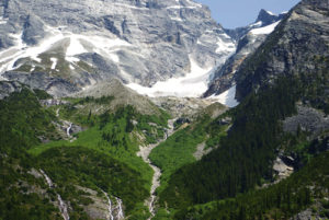
The grade continues, unrelenting in releasing progressively more astounding beauty as you move higher and higher. The forest progresses through the evolution to alpine within a short span of 150 to 200 m of elevation. The change is quite abrupt, and soon you are wandering over a boulder field that seems endless. This, however, is not the final destination. All sights in a 270° west, north and south arc are included in this stunning panorama, but the best is only another 134 m higher.
The view from the crest is magnificent. Lookout Mountain is 1.3 km to the southeast, while Young Peak is 4.1 km southward. The Asulkan Valley and Glacier are below almost directly south. Looking across the Illecillewaet Valley, you can easily spot Mount Sir Donald and Perley Rock along with the toe of Great Glacier. Breathtaking.
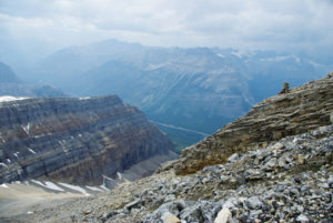
If you are feeling adventurous, continue down to the rocky exposure of the Illecillewaet Valley and proceed to the toe of the glacier. I would not recommend hiking on the glacier, though, unless you are properly equipped and knowledgeable. The unmarked, tailless region will gradually take you to the end of the Great Glacier Trail, allowing a complete, all-encompassing loop of these two marvellous routes.
Glacier Crest history
This ridge earned its name from members of the Appalachian Mountain Club in 1895. Glacier Crest is just that, a crest between the Asulkan and Illecillewaet Glaciers, providing spectacular views of both, with the Illecillewaet Glacier to the east and the Asulkan Glacier to the west. This sharp, narrow ridge was carved by glaciers that flowed down both sides of the ridge.
Directions
This and many other trailheads are situated in the Illecillewaet recreation region, just 3 km west of the Rogers Pass Centre on the Trans-Canada Highway. The area is signed on the highway as Illecillewaet Campground. Relative to other Rocky Mountain parks, this region is unknown.
The Illecillewaet recreational region consists of at least seven treks, two magnificent valleys, glaciers, streams, rivers, waterfalls, a mountain cabin, tarns, meadows, mountains, ridges, an Alpine Club of Canada hut, and historic ruins. If you wish to stay a couple of nights, there is a wonderful campground.
Before you begin, there seems to be a bit of an elevation conflict that you must be aware of. At the trailhead, Parks Canada states that the summit of the Glacier Crest Trail is 2045 m, and their website makes the same claim. It also says that the “elevation of crest” is at 2255 m. My GPS readings place the lengthy boulder field below the summit ridge at 2064 m and the summit arête at 2198 m. Whatever the case, I urge you to go the distance to achieve the true high point. The sight as you survey two distinct, beautiful valleys with just a turn of your head is unequivocally extraordinary.

Gerry Shea
“Gerry Shea moved to Kamloops from Vancouver at the age of nine, which is when he became enchanted by the nearby hills. It was on a family vacation many years later that he discovered the mountains and began hiking and climbing in his spare time, gathering knowledge and experience that he has since used to help beginning hikers, scramblers and backpackers to trek safely. Gerry lives in Kamloops with his wife and children.”Excerpt From: Gerry Shea. “The Aspiring Hiker’s Guide 2: Mountain Treks in British Columbia.” iBooks.