Distance
Travelling down to this valley bottom places the trail on the north side of the Howse River for about 1.5 km. The walk alongside this glacial silt river is exhilarating, as the vistas of the surrounding peaks become captivating. Sadly, though, within 20–25 minutes the trail leaves the Howse to pursue a lesser tributary and re-enters the narrower views within the forest. In the mountains, what goes down must go up, and the trail begins to ascend to 1622 m. After levelling off, the path roams through the lovely forest for 20 minutes before dropping sharply down to 1433 m to Glacier Lake Campground. The sharp descent is occupied by exposed roots and rocks, making it somewhat treacherous.
The decline ends just before the lake, and the trail forks with signage directing hikers to the campground. It is almost impossible to make your way to the campground without checking out the beach first, since the sight of the lake and surrounding peaks draws you like a magnet.
The day trip will take you around the north end of Glacier Lake to the far west end. The lake is 3.8 km long and 750 m across, making it the fourth largest lake in Banff Park. A coarse trail parallels the water’s edge to the end of the lake where it becomes less visible as it reaches the flats of the braided glacial runoff stream feeding Glacier Lake. Continue to follow the main branch of the Glacier River for 4–5 km farther to approach Southeast Lyell Glacier. Climbing moraines on the right side of the river offers even more amazing views of the glacier.

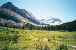
After crossing Fryatt Creek at Lower Fryatt Campground the path now begins to climb somewhat steeply upward through an increasingly thinner forest of subalpine growth. The grade ascends for 4.2 km acquiring 325 m before finally diminishing at the Fryatt Creek Bridge at kilometre 15.8. At this point, the wonder of this place on earth begins to unfold as the first sights of the Fryatt Valley begin to appear. The vast openness of the valley upon exiting the confines of the forest is unexpected yet welcome. Stick to the trail by following cairns and well-placed rocks in the stream to reach Brussels Campground 1.3 km up the valley.
Exploring this valley as well as the Upper Fryatt eliminates any hesitation about making this long voyage. Leaving the campground, climb over a small alluvial fan and descend slightly to reach Fryatt Lake. This is a beautiful place to just sit and relax. Spaces like this are rare and not usually encountered in our daily lives. Take as much time as needed here; all you have here is time and beauty. Just beyond the lake is a limestone rock wall called the Headwall. Fryatt Creek falls over the headwall to feed Fryatt Lake. To explore the Upper Fryatt Valley, climb the excruciatingly steep headwall, gaining 200 m in less than a kilometre. At the top of the headwall the upper valley opens up as you hike past the Alpine Club of Canada’s Sydney Vallance Hut.
History
Fryatt valley, creek and mountain were named after Captain Charles Algernon Fryatt (1872–1916) by the Alberta-British Columbia Boundary Commission. Brussels Campground and nearby Brussels Peak take their names from the Great Eastern Railway steamer Brussels, which was under Captain Fryatt’s command. The Brussels was an unarmed merchant ship that made regular runs on the Rotterdam/British East Coast route during the First World War and was very successful in eluding the Germans.
On two occasions, March 3 and March 28, 1915, Captain Fryatt avoided attack by German U-boats. In the latter incident, he was able to attempt to ram the submarine as it surfaced to line up a torpedo on the Brussels. The U-boat was forced to dive, narrowly averting a collision. Captain Fryatt reported, “You could have easily hung your hat on the periscope as she lay alongside us.” Fryatt was awarded a gold watch for each of his encounters with the submarines.
However, 15 months later, on June 23, 1916, his luck ran out as he was surrounded and captured by a convoy of German torpedo boats. In Bruges, Belgium, on July 27, 1916, Captain Fryatt was tried, found guilty of being a franc-tireur, or unlawful combatant, and executed later that evening, having written a farewell letter to his wife and six children.
Directions
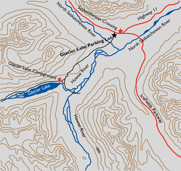
Drive north on the Icefields Parkway for 78 km from its junction with the Trans-Canada Highway, or 1 km north of Saskatchewan Crossing. The trailhead parking lot is on the west side of the Parkway.