Distance

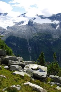
The path adheres to the hillside, climbing continually upward, passing two small weather-monitoring stations within a kilometre of each other. From the second of these weather stations, another kilometre of uphill strolling brings you to the official, signed end of the route. Cool glacial water runs freely down a rocky slope just beyond the trail’s end.
Beyond here, travel the massive, open rock slabs left behind by the Great (Illecillewaet) Glacier, and venture to its toe. This open region, and the ensuing route, has but one faint track that fades at a large cairn 400 m up the path. This trail is not on any maps. Elevation gained from the end-of-trail marker to the cairns is 139 m. To reach the toe of the glacier, continue, without the aid of trails, another 800 m of distance with an elevation gain of 290 m. To complete this outstanding uncharted journey, work your way up the right (west) side of the ridge to the Glacier Crest summit (N51 14 20.8 W117 28 02.7). The top of the Glacier Crest Trail is an additional 185 m upward.
Directions
The trailhead for the Great Glacier route is situated among many others in a scrambler’s paradise. The point of origin for all of these routes is at Illecillewaet Campground, 3 km west of the Rogers Pass Centre on the Trans-Canada Highway. Purchase your day pass at the small welcome centre and walk to where the pavement meets gravel. Watch for detailed signage that will guide you to the historic ruins of Glacier House.
From Illecillewaet Campground, follow the markers to the trailhead. The route passes through a clearing that contains the remains of Glacier House as it makes its way into the thick green forest. Five minutes in, the path splits, with signage sending you to the right-hand fork (straight). Another five minutes and a sign steers you left. The well-worn path cuts through this gorgeous, cool forest of western cedar, hemlock and undergrowth of ferns and moss, alongside the Illecillewaet River. During the notorious forest fire season of 2003, we hiked this valley with temperatures outside the forest at an intolerable 36° C, while inside, it was a comfortable and cool 29°.


Gerry Shea
“Gerry Shea moved to Kamloops from Vancouver at the age of nine, which is when he became enchanted by the nearby hills. It was on a family vacation many years later that he discovered the mountains and began hiking and climbing in his spare time, gathering knowledge and experience that he has since used to help beginning hikers, scramblers and backpackers to trek safely. Gerry lives in Kamloops with his wife and children.”Excerpt From: Gerry Shea. “The Aspiring Hiker’s Guide 2: Mountain Treks in British Columbia.” iBooks.