Distance
The hiking trail is steep, but its varied scenery keeps the hike interesting. The hike starts in the dense, cool, moist forest, refreshing on a hot day. The forest floor is soft and quiet, with the footfall of hikers’ boots cushioned on the carpet of needles. The trail is an inviting ribbon for travel.
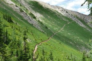
As the forest thins with rising elevation, the views expand and the hike climbs through alpine meadows. Mount Bastille’s lower buttresses and towering peaks and glaciers surround you. Regal subalpine larch trees escort hikers along the beautiful trail. Jumbo Pass Cabin
The hut is managed jointly by the Columbia Valley Hut Society (CVHS) and the BC Forest Service. It is on an alpine ridge overlooking the spectacular view. The shelter sleeps eight and a tarn is nearby for summer drinking water. A BC Forest Renewal grant and the CVHS built the cabin in 1997, and according the society’s website “it replaced a 30-year-old structure that had seen its better days and was too small to meet the demands of an ever-growing interest of hikers and skiers to the see the beautiful vistas of Jumbo Pass.”
Camping is welcome at the ridge, and reservations are not required. Please camp at least 100 m from the drinking-water tarn. Do not use firewood in summer, as it is expensive to fly in. The wood is for winter use only. Fires are not permitted in summer.
Go to Contact Information and References for Columbia Valley Hut Society reservation and contact information.
Current Events
The widely known controversy over the Jumbo Glacier Alpine Resort and the BC government has been droning on for almost 20 years. The disagreement is about permitting an extensive new resort at the headwaters of Jumbo Creek. The area is only a half-dozen kilometres or so from the border of the protected wilderness of the Purcell Wilderness Conservancy.

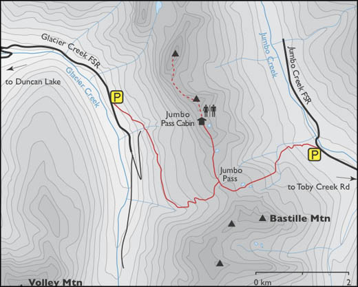
0 km: At the junction of Highway 31, south of Cooper Creek, turn north onto Duncan Creek FS Road.
11.8 km: Turn right onto Glacier Creek Road and follow it for 23 km.
34.8 km: Take the right fork near a second bridge near the end of the valley.
38.8 km: Park at the trailhead on the left (east).
The trail from Glacier Creek is 4.2 km and gains 700 m (2,300 ft.).
Trail
0 km: From the parking spot along Jumbo Creek Road, hike up the old logging road left (west). The trail is well-used and obvious. Almost immediately turn left again and hike up a steep trail. This is a new portion of trail that eliminates two tricky creek crossings. The trail ascends 61 m (200 ft.) steeply upward by the old cutblock.
1 km: Joins with the older trail in forest. After climbing 300 m (1,000 ft.) of elevation, you’ll notice subalpine meadows becoming more prominent. The trail steepens, with a trickling creek on your right. When you get to the steep alpine creek, pay attention to a square orange marker nailed to a tree. It indicates a sharp right turn (west) and across the creek. Continue west toward a rockslide below the dark-grey cliffs of Bastille Mountain. The trail crosses another tiny creek and begins to climb steeply in the grassy meadows. Flagging marks the route.
4.5 km: Scenic alpine tarn at 2280 m (7,300 ft.). After a refreshing rest, continue to climb to the ridge at 2280 m (7,500 ft.). Other small lakes enhance the view and shimmer in the morning light, reflecting Horseshoe Glacier.
5.2 km: Hike along the wide ridge to the right (northwest) to Jumbo Pass and intersect with the trail coming from the West Kootenay–Glacier Creek trail. Keep heading northwest along the main trail on the ridge.
6.1 km: Jumbo Pass cabin, N78870-E26694, is at 2,300 m (7,710 ft.) elevation.
Directions
any vehicle, though a 2WD car may have trouble in wet weather. Most years the road is high-clearance.
The drive from the highway to the trailhead is about two hours. Turn west from Highway 93/95 to Invermere. Turn right (north) at 2.3 km, at the signed Panorama Ski Resort/Wilmer Road.
0 km: From Invermere, drive north on the Panorama Ski Resort/Wilmer Road.
1.8 km: Turn left, west, to Panorama Drive, also called Toby Creek Road.
19 km: Continue past the Panorama Ski Resort.
24 km: Washed-out culvert may impede low-clearance vehicles.
37.6 km: Take the right fork (north) at the signed Jumbo Creek FS Road. (The left fork leads to Earl Grey Pass on Toby Creek Road.) Stay on the Jumbo Creek main road, parallel to the creek. Several logging roads branch off; take the next two left forks.
43.6 km: Turn left at Jumbo Pass sign (past the 5 km sign), and cross Jumbo Creek bridge to the south side.
50.8 km: Cross the Leona Creek bridge (14 km sign) and continue on the main road. Road bends and heads west beside Jumbo Creek. Before the bridge is a large sandy campsite.
52.8 km: Park beside the narrow road at the signed trailhead, at an old logging road junction on the left (south) (between the 15 km and 16 km signs).

Janice Strong
Janice Strong is an established professional outdoor photographer. Her images grace collections all over the world and appear in many respected publications. She is passionate about hiking and is also an avid snowshoer and skier, exploring the outdoors of the East Kootenay in southeastern BC year round.She openly shares her passion for the outdoors with others and has introduced hundreds of people to the joys of hiking. For a decade she led hikes for the City of Cranbrook – Parks and Recreation. With her guidance, many people have themselves become enthusiastic hikers.
Climbing mountains, finding new places and enjoying the experience of the journey have always been important to Janice. She cherishes the little things she sees along the trail, as well as the grand destinations.
When Janice is not writing, hiking or taking photographs, she is involved in various creative digital, website design or photographic projects for her clients. She and her husband, Jamie Levine, enjoy their rural property, near Cranbrook, BC.