Distance
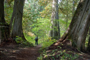
Volunteers plan and maintain the network of hiking and biking trails on the slopes of North Star Mountain. A series of old roads, single tracks and double-track trails braid through the mixed forest, grasslands and by several tiny ponds on the southwest side of Kimberley.
The trail network spans between the Kimberley Alpine Resort to the north and St. Mary’s Lake Road to the south. The trails include the Kimberley Cross-country Ski Trails, Dipper Lake, the forests west of the Blarchmont area of Kimberley, and Sunflower Hill.
The trails are diverse and well-maintained for hiking and snowshoeing. Most are good for mountain biking.
From St. Mary Lake Road parking, hike up the sloping dirt road northeast to a grand view of the Rockies to the east and Bootleg Mountain to the west. Another trailhead to Sunflower Hill is directly across the road from the Kimberley campground on St. Mary Lake Road. Hike the trail uphill (north) from the campground and connect with a T junction. Turn right at the T and in 500 m reach the bottom of a large grassy slope: Sunflower Hill. Lupines and yellow balsamroot sunflowers cover the hillsides in May and early June.
A trail heading west joins the top of the Sunflower Hill trail and connects with other trails in the Kimberley Nature Park, where you can complete a 6-km loop hike.

In Kimberley on Highway 95A, in the Blarchmont area, turn west on Higgins Street, drive a couple of blocks and park at the end of the road. This gives access to the shady Douglas fir forests and short 1- or 2-km signed walks to Eimer Pond.
Directions
Road: any vehicle
From Highway 95A, about 500 m north of Marysville, turn west onto St. Mary Lake Road.
St. Mary Lake Road
0 km: Junction of Highway 95A and St. Mary Lake Road.
2 km: Sunflower Hill – Kimberley Nature Park. Park at the small dirt road on the right (north) at the base of the grassy slope.
2.5 km: Kimberley Campground. Parking for slightly longer hike, but better parking spot.

Janice Strong
Janice Strong is an established professional outdoor photographer. Her images grace collections all over the world and appear in many respected publications. She is passionate about hiking and is also an avid snowshoer and skier, exploring the outdoors of the East Kootenay in southeastern BC year round.She openly shares her passion for the outdoors with others and has introduced hundreds of people to the joys of hiking. For a decade she led hikes for the City of Cranbrook – Parks and Recreation. With her guidance, many people have themselves become enthusiastic hikers.
Climbing mountains, finding new places and enjoying the experience of the journey have always been important to Janice. She cherishes the little things she sees along the trail, as well as the grand destinations.
When Janice is not writing, hiking or taking photographs, she is involved in various creative digital, website design or photographic projects for her clients. She and her husband, Jamie Levine, enjoy their rural property, near Cranbrook, BC.