Distance

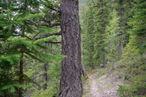
The wide trail, wide enough to walk side by side, meanders through a magnificent old-growth forest of Douglas fir, cedar, hemlock and spruce. The sight of these huge trees is breathtaking. They are truly glorious. This is unlike any forest in the Rocky Mountain park system. Even the damp odours from the ferns, mosses, lichens and fungi are exceptional. These natural surroundings remain unchanged until you reach the bridge over the Kinney Lake outlet at the 4.5-km mark. This tranquil setting is a popular spot to stop and rest, as the serene, fast, yet smoothly flowing stream quickly becomes intoxicating. Or maybe it is just popular because there’s an outhouse in the forest on the other side of the bridge.
Back into the lush forest, the path narrows as it sidesteps the lake. Another kilometre along, the second rise on this route begins to climb through a series of switchbacks. The trail to the Kinney Lake viewpoint intersects to the left partway through this modest elevation gain. It is worth the momentary detour along a well-constructed boardwalk to observe the lake from this precipice. The hike continues to ascend briefly, levels out, then descends to the lakeside once again.
The approach to the campground spans an outwash pan of sand and gravel. This entanglement of streams can present a minor inconvenience during high glacial runoff and you should utilize the wooden platforms provided for this crossing. Tent pads are available along the shoreline entering the campground that can be used to offset the effects of a hot summer day. More-protected tent pads are at hand in the forest surrounding the main campground. The common campsite area opens up with an impressive shelter at its heart that functions as a cooking area and meeting place. Splendid lakeside viewing is offered here along this treeless shoreline.
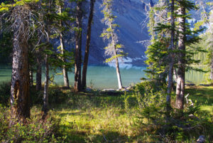
Kinney Lake is an archetypal glacier-fed lake, owing its aquamarine hue to its purity, enabling short-wavelength light to be reflected off tiny mineral particles ground by glaciers. The valley that this dazzling lake resides in was gouged out by retreating ice during the late Pleistocene period of glaciation, 30,000 to 21,000 years ago. As the ice melted, the resulting water filled gouged-out low spots to form the lake. Today, the lake’s source resides in the Robson glacial system: the combined Berg, Mist and Robson glaciers on the north rampart of Mount Robson. This system also nourishes Berg Lake and the Robson River. Directly across Kinney Lake, Cinnamon Peak and Whitehorn Mountain to the north (right) rise to confine the southwest shore of the lake. Drainage from snowpack in these mountains produces waterfalls that cascade hundreds of metres down the rock walls and into the lake.
Day trips from the campground depend on your stamina. The only direction is to go farther up the trail. This and much more about Berg Lake are discussed in the Whitehorn Campground
Directions
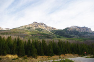
From Jasper, Alberta, the Mount Robson Visitor Centre is a straightforward, picturesque 85-km drive west on Hwy. 16. From the west, the trailhead is 35 km from Valemount, BC, though when leaving Valemount you must first head north on Hwy. 5 for 20 km and then turn right (east) onto Hwy. 16. Drive the remaining 15 km on Hwy. 16 to the visitor centre. From the visitor centre, turn right, onto Kinney Lake Road, heading north. Travel along the paved frontage road for 2 km to the Berg Lake trailhead parking lot. Park, strap on your backpack and cross the bridge over the Robson River to reach the trailhead.


Gerry Shea
“Gerry Shea moved to Kamloops from Vancouver at the age of nine, which is when he became enchanted by the nearby hills. It was on a family vacation many years later that he discovered the mountains and began hiking and climbing in his spare time, gathering knowledge and experience that he has since used to help beginning hikers, scramblers and backpackers to trek safely. Gerry lives in Kamloops with his wife and children.”Excerpt From: Gerry Shea. “The Aspiring Hiker’s Guide 2: Mountain Treks in British Columbia.” iBooks.