Distance
Lakit Lookout is a popular hike. The lookout is located on a wide and spacious alpine ridge, which offers a comfortable place to rest and enjoy the view. The trail is well-maintained but steep, so expect a short but vigorous hike. It takes about 45 minutes to 1.5 hour to reach the Lakit Lookout building.
The trail to the lookout is on a dry southern exposure. Pine trees dot the open slopes of sparse rocky soil. The plant communities are complex even at this high elevation, and the mountainsides are often covered by a diversity of wildflowers and grasses during the short summer growing season. Snow cornices on the ridgetop endure until almost the end of July.
The lookout offers the best view of its surroundings, but the real summit of Lakit Mountain is almost 2 km north along the ridge. The Lakit Mountain labelled on the topographical maps is just downhill from the ridge, but the main ridge bends east and a higher summit is what the locals call Lakit Mountain, N09400-E01300, at 2540 m (8,260 ft.).
Lakit Lookout Shelter
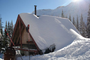
The Lakit Lookout building is open to the public and may be used as an overnight shelter. Reservations are not required. For two decades, hikers and skiers have watched many starry skies, full moons and lightning storms from this viewpoint on the top of the southern Rocky Mountains. A tiny wood stove keeps the uninsulated plywood cabin a little warmer than the outside. Firewood is carried up to the cabin on the backs of hardworking volunteers. Please don’t light the stove during summer.
The Lakit Lookout building is a replica, built by the BC Forest Service, of the old fire watchtower that stood on the same site until 1967. It used to be called Wild Horse Lookout. The structure was not the patrol residence, so the watchman would climb the trail every day during fire season. Fire spotting today is done by electronic lightning detectors and helicopter flyovers after lightning storms.
You may want to continue your day hike 2 km north along the ridge to the summit of Lakit Mountain. Broken-boulder-hopping and a bit of rock scrambling are required at the first dip along the ridge. This broken section of ridge is an obstacle for some, but the rest of the hike to the summit is a pleasant alpine tour.
Return to your vehicle by the same route, or you can descend down the eastern basin back to the road. Backtrack off the summit until the route down appears safe to descend. Start carefully by skidding down the loose rock and scree. In the basin, hike east and back to the road. Turn right and hike downhill on the road to the vehicles.

0 km: Walk about 400 m up the road from the parking area to a wide spot by Victoria Creek.
400 m: A trail marker is on the left (southwestern), uphill side. Hike the wide trail through alpine terrain up onto the ridge.
1.5 km: Hike along the crest of a wide ridge, heading west.
2.1 km: Lakit Lookout, N07900-E01106. Wide spacious meadow with a picnic table and outhouse sits near the ridgetop. The lookout shelter is anchored to the rock with sturdy cables, as this is very windy spot.
Directions
Road: rough condition; drop-offs on sidehill beside narrow road; intimidating for some; 4x4 high-clearance vehicle; steep and rocky; use an ATV, and watch out for vehicles
Follow the detailed road directions under Wild Horse River.
0 km: Junction of Wild Horse Creek Road and Wardner/Fort Steele Road
7 km: On Wild Horse FS Road, for Lakit Lookout, turn left (northwest), N02373-E02367 (between 6 km and 8 km sign). A vertical signpost marks Lakit Lookout.
Reset odometer to 0.
Lakit Road
0 km: Lakit Lookout Road and junction with Wild Horse FS Road.
200 m: Take the right fork. The rest of the road is a precipitous pickup truck road that climbs along the flank of a mountainside for almost 8 km. This narrow, steep and rocky road requires caution and good driving skills. The road is maintained to some degree.
3.6 km: Take left fork uphill.
7.4 km: Park at a wide and graded spot on the outside edge of a left curve, N08500-E02400. Parking for about seven vehicles. The road continues another 400 m, but it slopes on the steep sidehill and big rocks fall onto the road, narrowing the span. You have to back up if an obstacle or late-melting snow blocks the road.

Janice Strong
Janice Strong is an established professional outdoor photographer. Her images grace collections all over the world and appear in many respected publications. She is passionate about hiking and is also an avid snowshoer and skier, exploring the outdoors of the East Kootenay in southeastern BC year round.She openly shares her passion for the outdoors with others and has introduced hundreds of people to the joys of hiking. For a decade she led hikes for the City of Cranbrook – Parks and Recreation. With her guidance, many people have themselves become enthusiastic hikers.
Climbing mountains, finding new places and enjoying the experience of the journey have always been important to Janice. She cherishes the little things she sees along the trail, as well as the grand destinations.
When Janice is not writing, hiking or taking photographs, she is involved in various creative digital, website design or photographic projects for her clients. She and her husband, Jamie Levine, enjoy their rural property, near Cranbrook, BC.