Distance

About 10 minutes into the hike, you confront the first minor fork in the trail. While it may be tempting to continue straight down a well-trodden path, turn left onto the bridge instead. The fork that carries on straight quickly comes to an end as it meets water.
After crossing the bridge, the path comes head-on to a small offshoot of the Adams River a few short minutes later. Here, the trail T-splits. Take the left fork and parallel the west shoreline of the Adams River.
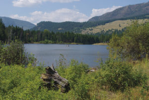
At the 2 km (30-minute) mark of the journey a trail branches to the left at a 90° angle. Continue straight along the riverside, and five minutes later you will pop out of the forest into a solid rock clearing. Below you is a torrential back eddy caused by the very rock outcropping you are standing on. This swirling action has fashioned a fabulous beach about 15 to 20 metres wide, with a depth that varies with the water level.
You can return the same way or complete a small loop that reconnects with the trail at a point you passed five minutes before you arrived at the beach. The trail is marked with cairns exiting the beach into the forest, and it climbs slightly uphill for a couple of minutes. Turn left when you approach a grass-covered road, and a minute of walking down this road will bring you to a left turn down a trail that places you back on the main riverside trail. Turn right and head back to the trailhead.
Directions
From the village of Chase, travel east on the Trans-Canada Highway for 10 km until you reach the turnoff to the North Shuswap region. This right turnoff from the highway takes you onto the Squilax–Anglemont road. From the Squilax bridge, across the Little River, drive the Squilax–Anglemont road for 3 km and turn left on Holding Rd. Carry on along Holding Rd. for 5 km and pull into the parking area on the right side of the road. The trailhead is obvious, as signage for Lower Flume Trail directs you into a forest.