Distance
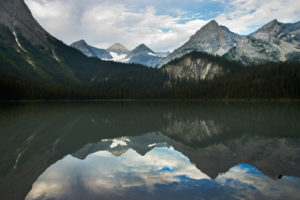
The impressive Shark’s Tooth only becomes visible when you finally crest the rim of the pass. The pass is on a spacious alpine ridge, about 1 km long, hugging the eastern rim of the cirque. Blue Rocky Mountain summits ripple away to every horizon.
Marmalade Creek is only replenished by snow and rainfall; there are no icefields in the high country of this region. As a result, the creek is dry along most of the route after years of drought.
Further explorations
Ram Creek Hot Springs
The wilderness Ram Creek Hot Springs are 13.3 km along Ram Creek Road (see Drive, in the margin). Blocky boulders rim the parking lot and a firepit. The Hot Spring is a BC protected area and 1-m-deep, clear, pale-blue pools are warm to the touch, not hot. Hike 20 m up a short trail to the pools. There are no facilities. It’s a great place for a soothing soak after a day hike to Marmalade Creek, but you may want to wear a bathing suit, as the pool is very close to the road. Please keep the area clean and pick up garbage others may have left.
0 km: Parking spot. Hike around the slash at the north end of the landing and look for a tiny trail heading into the forest. The trail bends left and crosses tiny Marmalade Creek. Hike generally northeast along the creek in a scraggly fir forest parched from years of drought. The creek is dry about 1 km up the trail, and that is the last water on the entire hike. There are lots of blowdowns and the trail is rarely maintained.
1.2 km and 2 km: Cross the dry creek bed. After the second crossing the trail is indistinct in places as washouts and tangles of trees obscure the route. Keep following the main creek channel on fragments of trails and the bush is reasonably open. These trail fragments are easy to navigate and easy to travel. There is only about 500 m of indistinct trails.
3.2 km: Open grassy slope, below a cirque of limestone, N46200-E02080, at 2020 m (6,620 ft.). The views and open spaces make this a pleasant spot for a break. A few wildflowers grow in the tall grass and trees rim the edges of the basin. Shark’s Tooth is still hidden. Hike northwest (left), following the steep creek gully and gain another 300 m (1,000 ft.).
4.6 km: The pass and the view of Shark’s Tooth Mountain, N47000-E01300, at 2370 m (7,800 ft.).
Directions
Road: high-clearance vehicle; bumpy and rocky; 4x4 or ATV last 3.6 km
0 km: From Highway 93/95 turn east to Premier Lake Provincial Park (1 km north of the town of Skookumchuck).
800 m: Continue straight (left fork just bends back to the highway).
6.7 km: Take left fork, Wasa Sheep Creek Road (right fork leads to Premier Lake Provincial Park).
9.5 km: Turn right (east) at a T intersection onto Sheep Creek Road, N36479-E95157 (left is Island Pond road). Road bends north and in 1.3 km there is a “Road Closed – No Through Road” sign. This sign only means the road doesn’t go through to Top of the World Provincial Park anymore; the road is very drivable to Ram Creek Hot Springs. Continue driving north on the main road.
15.1 km: Right fork.
19.2 km: Turn left off the main road onto a tiny dirt track, N43511-E99605. (If you stay on the main road another 600 m, pass a bush campsite and in another 800 m arrive at the parking for Ram Creek Hot Springs. See Further explorations, below.)
19.5 km: The tiny dirt track requires an ATV or high-clearance 4x4 and is steep in places. Cross a muddy section. In 300 m from the main road, intersect with a larger old road. Turn right, uphill. Follow this deteriorating road up 2.2 km to a turnaround just before a creek crossing.
21.4 km: If the crossing is drivable, continue. The road is very steep and narrow past the creek and there are few places to turn around until it ends. Take the right fork uphill, 1.4 km from the creek. Just 100 m farther is the wide flat parking spot.
22.8 km: Park at the end of the logging block, N44681-E00864, at 1600 m (5,250 ft.)

Janice Strong
Janice Strong is an established professional outdoor photographer. Her images grace collections all over the world and appear in many respected publications. She is passionate about hiking and is also an avid snowshoer and skier, exploring the outdoors of the East Kootenay in southeastern BC year round.She openly shares her passion for the outdoors with others and has introduced hundreds of people to the joys of hiking. For a decade she led hikes for the City of Cranbrook – Parks and Recreation. With her guidance, many people have themselves become enthusiastic hikers.
Climbing mountains, finding new places and enjoying the experience of the journey have always been important to Janice. She cherishes the little things she sees along the trail, as well as the grand destinations.
When Janice is not writing, hiking or taking photographs, she is involved in various creative digital, website design or photographic projects for her clients. She and her husband, Jamie Levine, enjoy their rural property, near Cranbrook, BC.


