Distance
The Mause Creek tarns are a clump of four or five very shallow tarns rimmed with larch and fir trees, heather and low bushes. The tarns are scattered throughout an open fertile meadow dotted with monkey flowers and purple asters (or showy daisies). The flowers are their best in the first two weeks of August, provided there has been enough rainfall and the flowers have not suffered a midsummer frost during mid-bloom (common in recent years). If the weather co-operates, the lower meadow by the first tarn is crammed with flowers. Summer is the most popular season to visit the tarns.
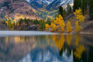
Autumn used to be my favourite time to visit the Mause Creek tarns, but over the last five years a blight of some sort has killed most of the dramatic alpine larch trees in the area. The area that once was so beautiful now looks like a swath of gnarly posts. It will take a decade or so for the immature larch that didn’t succumb to take up prominence again.
Mause Creek makes a good destination in winter, although the road is not maintained. Ski touring in the basin is good for intermediate skiers, and steep mountain slopes welcome more experienced enthusiasts. Caution must be exercised, as most of this area is avalanche terrain.
Further explorations
Tanglefoot Lake
The hike to Tanglefoot Lake (see entry #37) is my personal favourite. The hike has everything, from a nice lake, high ridges, healthy larch forests (for now), great views and carpets of wildflowers.
Five Passes
The passes are easy to cross in this compact hiking area and there are many rewarding destinations (see entry #39).
The Five Passes trail is a loop traverse that begins at the Mause Creek trailhead, crosses over into Sunken Creek and into the Tanglefoot Lake area. Eventually the connection brings the weary hiker all the way back to the vehicle. It is not a new trail, but the connections to the passes are worn and obvious enough to be hiked.
Unnamed Mountain south of tarns
The mountain just south of the tarns offers a view out to the Rocky Mountain Trench and is a good uphill workout. Make your way up through forest and some steep sections gaining 90 m (300 ft.) to a pass. From the pass, hike west (right) up a rocky, but an accessible grey mound of a summit and gain another 200 m (700 ft.) to the top 2370 m (7,800 ft.).
Eastern tarn
Just east of the Mause Creek tarns and up 160 m (540 ft.) is another scenic tarn tucked amidst the grey rock. Hike up through the open forest to the east of the main group of tarns. The trees are widely spaced and the slope is crossed with a few rock bands, which are easily avoided. A few bubbling creeks and springs emerge from the soil. The eastern tarn, N95938-E12376, is at 2220 m (7,287 ft.) elevation.
For a good view down into blue-green Tanglefoot Lake, hike up the talus slope east above the eastern tarn and gradually hike left to the north ridge, up a series of blocky talus steps. At the ridge look to the right and see Windy Pass. It is the low alpine pass about 500 m away.
History
The Victor Mine was established in 1893. At that time some free gold in a thick, copper-stained quartz vein was reported. Today, ruined logs, planks and metal junk are piled into a mound. The site used to be a thriving mine with several buildings, a concentrator and a trestle leading up to the tunnel. The tunnel is still visible up on the rocky slope above the creek trail on the way to the tarns.
Rating: moderate
Time: short day hike
To Tarns:
Distance: 3.1 km
Elevation gain: 405 m (1,330 ft.)
Mause Creek Tarns: 2118 m (6,950 ft.)
To Tanglefoot Pass:
Distance: 3.5 km
Elevation gain: 535 m (1,750 ft.)
Tanglefoot Pass: 2345 m (7,369 ft.)
Trail: good trail to main tarns; small creek crossings
Maps: 82G/11 Fernie, (NAD27); 82G/12 Cranbrook (NAD83)

0 km: From the parking spot on Mause Creek Road, at elevation 1707 m (5,600 ft.), where a new bridge spans Mause Creek, walk up the road 1 km and cross the small creek again. The second crossing doesn’t have a bridge, but there are enough rocks to hop across. Continue up the road for another 1 km to the third crossing. This creek is attractively coated in smooth moss and the easy crossing is on an old plank.
1.9 km: This third creek crossing is just metres before the abandoned Victor Mine site. It is the junction with Five Passes trail, N96196-E11048, at 1960 m (6,434 ft.). For the Five Passes trail, from the road by the mine debris, look southwest across a brushy meadow for a faint trail. There is a faded orange marker on a tree at the trail junction.
2 km: For Mause Creek and Tanglefoot Lake, continue on the old road, and another 130 m past the mining debris the road ends. There are two ways to reach the Mause Creek tarns:
1. Scenic route,
Ceek trail. Head straight (south) and follow the creek trail east in a scenic alpine valley. A trickling creek is on your right as you head into the meadow. The well-worn trail bends left and climbs a steep section.
2. Faster route
Forest trail. From the end of the road look left up into the forest and the trail switchbacks left uphill. I use the forest trail for the way down. When you are up at the tarns in the lower meadow, heading downhill, go straight for the forest trail. (The left turn in the meadow just below the tarns leads back down the scenic route).
2.8 km: Both trails climb up and meet in the lower meadow by the tarns, N96129-E11621.
3.1 km: Follow the trail to the north tarn. Just north of the tarns the trail climbs a talus slope and gains 120 m (400 ft.) of elevation. Zigzag on a defined, cairn-marked trail up and slightly to the right (northeast) to Tanglefoot Pass.
3.5 km: Tanglefoot Pass, N96438-E12069, at 2345 m (7,369 ft.). For Tanglefoot Lake, go here.
Directions
Drive
Road map; also see the detail map of the area accessed from Wardner/Fort Steele Road
Road: high-clearance truck or 4x4
Follow detailed road directions to the Mause Creek and Wardner/Fort Steele roads.
0 km: Junction Mause Creek Road and Wardner/Fort Steele Road.
10.1 km: Mount Fisher trailhead on Mause Creek Road; Continue 3 km more on a steep road that is deteriorating, exposing broken sharp bedrock, one deep waterbar ditch and mudholes.
13 km: Park in a large graded area at the end of Mause Creek Road, 13 km. Motorized vehicles are not allowed past the parking lot or across the creek.

Janice Strong
Janice Strong is an established professional outdoor photographer. Her images grace collections all over the world and appear in many respected publications. She is passionate about hiking and is also an avid snowshoer and skier, exploring the outdoors of the East Kootenay in southeastern BC year round.She openly shares her passion for the outdoors with others and has introduced hundreds of people to the joys of hiking. For a decade she led hikes for the City of Cranbrook – Parks and Recreation. With her guidance, many people have themselves become enthusiastic hikers.
Climbing mountains, finding new places and enjoying the experience of the journey have always been important to Janice. She cherishes the little things she sees along the trail, as well as the grand destinations.
When Janice is not writing, hiking or taking photographs, she is involved in various creative digital, website design or photographic projects for her clients. She and her husband, Jamie Levine, enjoy their rural property, near Cranbrook, BC.