Distance

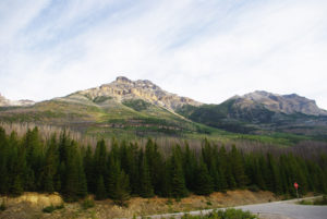
As the trail winds upward beyond the stream, the forest opens and the view of Field and its rocky guardians becomes ever clearer. This scenery makes the continual climbing tolerable. Another kilometre brings the path to a wide, dry avalanche trench. The power of tumbling snow is evident, as the underbrush and trees have been replaced by a broad swath of rock and rubble. To cross this debris field, follow cairns and a faint track. Once on the other side, follow the cairns up the avalanche slope until the trail into the forest reappears on your right. Someone from Parks Canada has packed a chain saw up here to cut a convenient notch in a large fallen tree for us.
For another 45 minutes, the forest gradually thins and the trees become shorter as you reach the subalpine. Look for a tree on the right that has two distinct axe or hatchet wedges hacked from it. An additional 15 to 20 minutes past this tree, on the left side of the open hillside, is a faint track leading to the summit. There are piles of rocks on either side (GPS N51 24 56.0 W116 29 30.4; elevation 1783 m). From this spot, the faint track to the summit of Mount Burgess takes off to the left onto the exposed slope, toward an easily spotted island of trees.
As the trail winds upward on solid ground toward the tree island, keep to the right side of it. The ground is firmer there, with less talus. Beyond the island, the path becomes a long chute that has loose rubble in the middle, so again keep to the right whenever possible. There are a few minor rock bands that require climbing, but they are only a couple of metres high at best. The clambering through the chute becomes incessant and you’ll emerge from it twice before the summit finally comes into view.
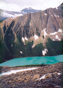
Across the Kicking Horse River, Mount Stephen looms so large that you feel you can reach across the valley and touch it. Emerald Lake sits below Mount Burgess to the northwest, while Mount Field is just next door to Mount Burgess, at 80° east.
Mount Burgess history
Alexander MacKinnon Burgess was Deputy Minister of the Interior in 1886 when Otto Klotz named Burgess Mountain and Burgess Pass for his superior officer. By 1897 Burgess had become the federal commissioner for public lands. The Burgess Shale fossil beds, discovered later in Burgess Pass, were also named after him.
Geologists and paleontologists have called the Burgess Shale the most significant fossil discovery in 100 years. The fossils’ age – some 505 million years – and finely detailed preservation are unique in the world. The broad diversity of organisms, mainly trilobites and small, shrimplike creatures, flourished on a warm, shallow seabed. Mudslides periodically reburied the creatures, and over millions of years their remains turned to stone from the immense pressure of the overlying sediment that at one time was more than 10 km thick. As the Rocky Mountains were pushed upward about 175 million years ago, the ancient seabed also shot upward, putting the trilobites now atop a mountain pass.
The Burgess Shale was discovered by the secretary of the Smithsonian Institution, Charles Doolittle Walcott, on August 30, 1909. He had studied a much lesser bed on Mount Stephen in 1907, which had been found by Otto Klotz in 1886 on a horse trail in Burgess Pass.
J.J. McArthur was the first person to climb to the summit of Mount Burgess, in 1892. While surveying the Rocky and Selkirk ranges for the CPR, McArthur climbed many of the mountains throughout this vast region, claiming many first ascents as well. Mount McArthur in the Little Yoho Valley was named after him in 1886 by Otto Klotz.
Directions
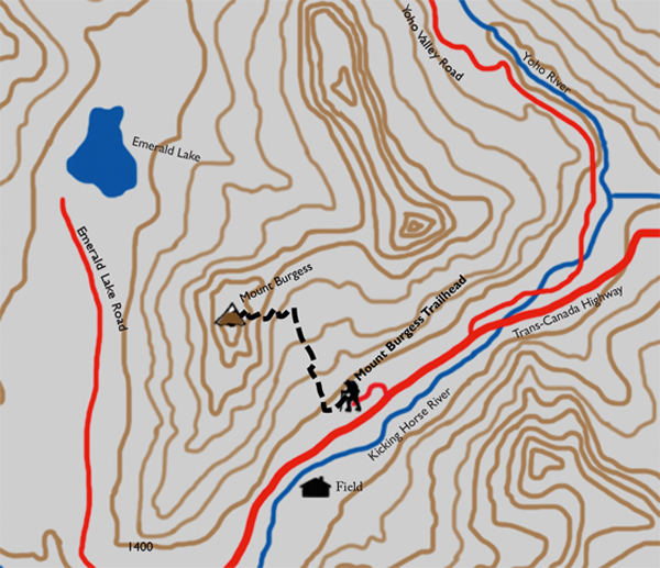
From the Yoho National Park Information Centre in Field, head east on the Trans-Canada Highway for 1.4 km. Turn left (north) onto the only unpaved road and immediately make a left at the first fork. Keep left for 400 m and the Burgess Pass trailhead will greet you.
Within the first couple of minutes you’ll pass a rare find of natural springs, on your right. There seem to be two or three of these underground aquifers spouting from the hillside and beneath rotting logs. A fork in the path lies just beyond them. Choose the right-hand trail.
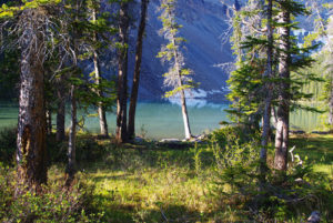
In a forest of Engelmann spruce and lodgepole pine, there are the occasional western red cedars that seem completely out of place. These sporadic trees are taller and thicker than the other evergreens and have distinctive grey, vertically lined bark.
About 500 m into the hike there is a short boardwalk of stairs consisting of about six long platforms. Although the boards are old, there is a distinct smell of damp, exposed wood when they are wet. This smell, combined with that of a few nearby western red cedars and a mossy forest floor, results in a unique scent unlike any other I have experienced in the Rockies.

Gerry Shea
“Gerry Shea moved to Kamloops from Vancouver at the age of nine, which is when he became enchanted by the nearby hills. It was on a family vacation many years later that he discovered the mountains and began hiking and climbing in his spare time, gathering knowledge and experience that he has since used to help beginning hikers, scramblers and backpackers to trek safely. Gerry lives in Kamloops with his wife and children.”Excerpt From: Gerry Shea. “The Aspiring Hiker’s Guide 2: Mountain Treks in British Columbia.” iBooks.