Distance
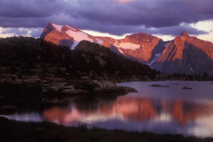
It rises high above Cranbrook’s eastern skyline and dominates the view from Fort Steele by the Kootenay River. Mount Fisher soars 300 m (1,000 ft.) above its neighbours, granting it special nobility and making the climb to the peak a memorable hike. The views feature a panorama of the Kootenay River valley and the Rockies spreading out to the pastel blue horizon.
Although no technical skills are required, this popular route up Mount Fisher is strenuous and challenging. Sturdy footware and experience in alpine routefinding are essential for this tour. The lower half of the trail is a steep forested slope, sheltering the hiker from the wind and heat of the sun. About halfway up, two tarns and gentle springs bubble over mossy slopes, with wildflowers gracing the banks.
As you gain elevation, boulder slopes, loose talus and scree span into the upper cirque. Scrambling with potential exposure is required near the col and above, where the mountainsides descend below you, visually uninterrupted.
The upper part of Mount Fisher is unmaintained, with several routes leading to a tiny platform of rock at the top. The safest route is now evident with reflective markers on the rock.
Sitting on the rock platform at the peak, I was frozen with fear and reduced to literally crawling over the rocks on my hands and knees. I couldn’t move or even take photographs, and I certainly could not look down.
In summer, it is best to start hiking by 7 a.m. so that you can reach the col before it is in direct sun. As you hike, be aware of others below you. This is a busy trail during summer and especially on weekends. Try not to dislodge any rocks or even small stones, and if you do, shout a warning. Do not travel directly above another party. Hiking times vary from two to six hours to reach the summit.
Bring plenty of drinking water, as the open, rocky slopes face south and can get very hot. Water is only found in a couple of places. Extra clothing may be welcome when the mountain weather changes suddenly. The winds are cool at high elevations and afternoon lightning storms are not uncommon.
Although Mount Fisher is one of the more difficult trips in the area, it is often the only hike that many local residents will attempt. The trip is more rewarding if you are in shape beforehand. (Mount Stevens trail to Teepee Mountain is a good training hike, as it climbs the same elevation as Mount Fisher but on a good trail instead of loose rock. See entry #47.)
The summit platform is small, accommodating only a few people at a time. Be courteous; during sunny weekends in summer, hikers may be lined up waiting for a turn to sit atop the summit!
In addition, the descent is more difficult than the ascent, so you will want to reserve plenty of time for the return journey. After the difficult climb, muscles may be fatigued and many or not prepared for the steep descent. You may wish to use hiking poles, which will help you ascend and descend through the forest.
Leave ski poles, ice axes, bear spray etc. tucked in a safe place on the col, as they will hinder your movement on the final segment. Consider whether you can assist your dogs through the tricky bits ahead! (My little dog needs a boost or hoist in many places and she needs to be on a short rope so she doesn’t make poor decisions. She has knocked a rock down on my knuckles and shins more than once! —GW)
0 km: Park at signed trailhead N98900-E07500. Leave room for other vehicles to park and pass. The trail heads north into the forest. The trail switchbacks often as it gains elevation rapidly, heading northeast. After climbing 220 m (730 ft.), you find the forest thinning as you enter an old rockslide. Hear the sound of a small creek and ascend beside the creek.
900 m: The creek is underground below the rocks, where sometimes it crashes in noisy torrents unseen just beneath your feet. The trail heads up the left of the open rockslide, staying just below the steep rocky centre of the slope.
1.5 km: View of the tall thin waterfall. Turn left off the rocks. Sometimes it’s boggy. There is a big firepit in woods to the left. The trail heads up the left side of the valley, N99500-E08000, at 1930 m (6,340 ft.) elevation. Trail continues to climb in the trees, less steeply than the first section.
1.9 km: Route contours through rocks. It may be a little indistinct here, but stay parallel to the creek above waterfall, at 2060 m (6,775 ft.). The route bends east to the back of the cirque.
2.2 km: Follow creek to the right through a short tongue of trees (many smashed in recent avalanches) and arrive at lower tarn at 2157 m (7,070 ft.). Stay on climber’s left around two small tarns, then reach bottom of basin, where there is a bench, firepit and outhouse.
From the tarns, head east up into the scree basin, following reflective markers to avoid going too far to the right. There is often snow here into July. There are few hand- and footholds and the rocks can be sharp and slippery, too. Shout if you knock a rock loose! Tumbling rocks can be dangerous to hikers below you, and be aware of rocks dislodged from careless hikers above you. (This in my opinion is the ugly part of both ascent and descent.) Wearing a helmet might offer you safety from falling rocks.
3.9 km: Col at 2528 m (8,290 ft.). Once at the col, climb up to the left (north) and follow one of several paths up directly above the col, heading toward some big blocky boulders with yellow lichens. There are reflective markers here to help you keep on the route. Do not go too far right or left or make any exposed moves. You should generally not be able to look way down into either basin if you are in the safest area.
4.5 km: At the summit of Mount Fisher, 2845 m (9,336 ft.), traverse left about 20 m to the summit post and register, N00431-E09398. (Distance readings to the summit are inconsistent, as hikers move slowly and unevenly across the slopes, complicating the GPS signals. The various distances we have measured are from 4 km to 6.8 km. (Trail research by GW.)
Directions
Road: steep and rocky; 4x4 high-clearance vehicle necessary for last few kilometres
Follow detailed road directions to Mause Creek and Wardner/Fort Steele roads.
0 km: Junction of Mause Creek Road and Wardner/Fort Steele Road.
10.1 km: Mount Fisher trailhead on Mause Creek Road.

Janice Strong
Janice Strong is an established professional outdoor photographer. Her images grace collections all over the world and appear in many respected publications. She is passionate about hiking and is also an avid snowshoer and skier, exploring the outdoors of the East Kootenay in southeastern BC year round.She openly shares her passion for the outdoors with others and has introduced hundreds of people to the joys of hiking. For a decade she led hikes for the City of Cranbrook – Parks and Recreation. With her guidance, many people have themselves become enthusiastic hikers.
Climbing mountains, finding new places and enjoying the experience of the journey have always been important to Janice. She cherishes the little things she sees along the trail, as well as the grand destinations.
When Janice is not writing, hiking or taking photographs, she is involved in various creative digital, website design or photographic projects for her clients. She and her husband, Jamie Levine, enjoy their rural property, near Cranbrook, BC.


