Distance
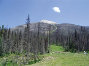
This ranks as one of the best-ever summit climbs, simply because the journey to the peak is astounding. The hour-long walk from Little Yoho Campground to Kiwetinok Pass is littered with meadows, streams, glaciers, waterfalls, moraines, mountains, a magnificent lake and a smattering of trees. Enjoy this magnificent walk. There are many like it, but none quite like it.

We once ran into some fellow hikers here who apparently made this very mistake. They told us they were on their way back down from Kiwetinok Pass. But as we talked with them, we realized they could not have reached the pass. They were directing us to take the trail on the near side of the second river and follow it up to the pass, but when I asked about Kiwetinok Lake, they replied there was no lake. It was obvious they’d made a navigational error and could not possibly have reached the pass by the route they were recommending. They seemed happy with their day’s accomplishment, though, so we saw no reason to set them straight. But the point here is that even though there is a well-trodden path up the near bank of the second river at this spot, you still have to cross the river.
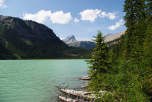
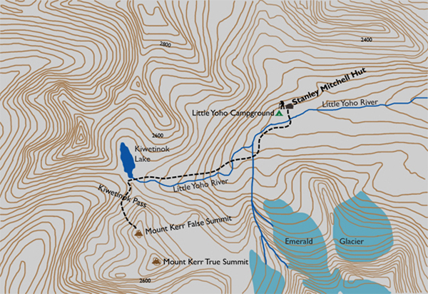
On the far side of the second crossing, search out the abundance of cairns and follow them back downstream to pick up the main trail again. The path resumes in sparse forest and continues to climb gradually, with sporadic steep grades, up to an immense, treeless alpine that will stun you. Up here, the grade levels out substantially and is barely noticeable as you wander toward Kiwetinok Lake. Take time to look around and venture off track. A nifty little stream that empties the lake and surrounding glaciers cuts into the ground over to the south (your left), only 20 to 30 m away. Numerous small waterfalls populate the cool, tranquil stream that has cut its way through the solid limestone beneath the soil you are standing on. At some point, step across the small drainage stream of the lake. At Kiwetinok Lake you are visiting the highest named lake in Canada. To the left (west) of the lake is a quick 33-metre jaunt up to the summit of Kiwetinok Pass.
Head south (left) toward the north slope of Mount Kerr and look for a suitable route. Only 313 m of elevation remains before you conquer the first summit of Mount Kerr, and the way is strewn with cairns and trails. Since the slope is reasonably firm and lacks substantial scree, it is just a matter of following one of many paths to the summit. The only noteworthy formation is a modest col just before the summit.
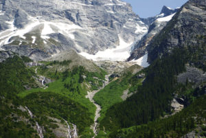
You will not believe your own eyes. This is unquestionably some of the best scenery on the entire planet. Glaciers resting between peaks and clinging to the sides of mountains, glacier-worn rock, glacier-fed streams and many mountain peaks indulge the eyes. The President Range dominates the eastern sky and the Kiwetinok Range covers the western horizon. To the southeast, Mount Marpole appears to be within throwing distance 2.3 km away, with Mount Carnarvon twice that far almost due south. Your next goal, Mount Pollinger, lies directly north on the other side of Kiwetinok Lake.
Mount Kerr history
This mountain was first ascended by Edward Whymper in 1901, and in 1907 Whymper named the peak for Robert Kerr, a CPR passenger traffic manager who had helped publicize Whymper’s arrival from England and his tourism-building travels throughout the Rockies and the Selkirks.
One of Kerr’s responsibilities was to promote the railway’s mountain destinations by bringing in big-name mountaineers and guides, and his greatest achievement was the importing of Edward Whymper, the celebrated British mountaineer credited with the first ascent of the Matterhorn. Kerr arranged to have all of Whymper’s expenses covered by the CPR while in Canada promoting the railway and its hotels. For this effort, Whymper named Mount Kerr as a sign of his gratitude to his sponsor.
Two of Whymper’s guides, Joseph Pollinger and Christian Kaufmann, expressed their desire to have the peak named after them. Whymper was steadfast, however, in naming not only this mountain for Kerr, but a second peak after another sponsor from the CPR, Richard Marpole. Whymper sealed the honour by inscribing the names on his official map.
In 1910, another Canadian place also became a namesake of Robert Kerr: the town of Kerrobert, Saskatchewan. Kerr’s job as passenger traffic manager included the railway’s Saskatchewan segment, and the town became a divisional point and trading centre for a large surrounding district at the time. The promise of further economic development fell short, however, and the community never really blossomed as expected. Today its population is about 1,000.
Directions
For directions to the Stanley Mitchell Hut, refer to the Little Yoho Campground hike.
With the Stanley Mitchell Hut as the starting point, get on the route toward the Iceline Trail and cross the Little Yoho River. Within five minutes from the river crossing, a sign to Kiwetinok Pass guides you to a gentle stroll along the river. This is short-lived, however, as a climb up a hillside interrupts this riverside walk. This ascent is just as short, but it becomes well worth the five minutes of panting as the sky soon opens up out of the forest to reveal an incredible torrential river draining a glacier that is parked in a cirque up to your left.

Gerry Shea
“Gerry Shea moved to Kamloops from Vancouver at the age of nine, which is when he became enchanted by the nearby hills. It was on a family vacation many years later that he discovered the mountains and began hiking and climbing in his spare time, gathering knowledge and experience that he has since used to help beginning hikers, scramblers and backpackers to trek safely. Gerry lives in Kamloops with his wife and children.”Excerpt From: Gerry Shea. “The Aspiring Hiker’s Guide 2: Mountain Treks in British Columbia.” iBooks.