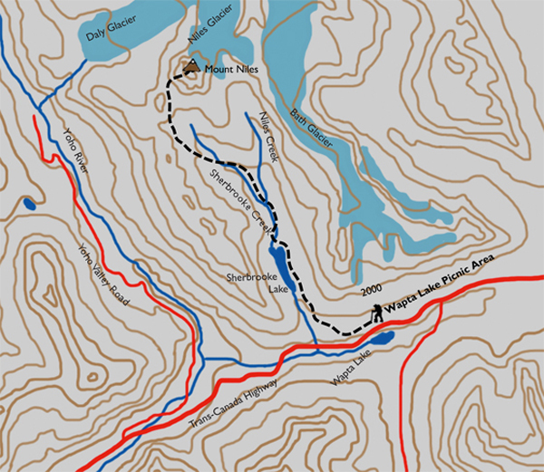
Distance

The path leaves the openness of the meadow for a forest and switchbacks that deliver more waterfalls along the way before meeting an exposed subalpine region of stunted trees and pastures another half-hour upward. There is some minor rockhopping and log walking required to cross the few streams that drain this area. Sticking to the trail for a further kilometre brings you to another small creek crossing at the base of a small, open, grassy meadow with the magnificent Mount Niles straight ahead. Directly across the valley, look for a rather large cairn that marks the start of an uphill battle. The cairn sits at the base of a drainage outlet that is usually dry. Walk up the drainage for about 50 m until you reach a well-defined track on the right. This path is a saviour of lungs, as it switchbacks up the hillside. If you miss this trail, there is no other way but straight up the dry gulch. An hour of hiking brings you to a rolling meadow that eventually hooks up with a scree slope at the base of the summit push. You have hiked 8.8 km from the trailhead.
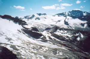
The way from here is a straightforward jaunt across the base of the scree slope to the far left (west) side of Niles Knoll. The trail has faded, so make your own way across and up, wrapping around the far side. Upon successfully reaching the obvious col, continue on a path that progresses up to the top of the knoll along the summit ridge.
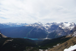
Views from this vantage point are overwhelming as the Wapta Icefield comes into view to the north and Mount Daly to the northeast, while directly south lies the wonderful valley you’ve just hiked up.
Mount Niles history
The mountain was named after William Harmon Niles by Charles S. Thompson in 1898. Niles was one of the first explorers to climb the mountains of the Yoho area. He was a professor of geology at Massachusetts Institute of Technology and served as president of the Appalachian Mountain Club. The first ascent of this wondrous peak was by D. Campbell and C.E. Fay in 1898.
Directions
The trailhead is on the north side of the Trans-Canada Highway, 11 km east of the town of Field, BC. Park in the Wapta Lake picnic area and you will easily locate the signs directing you to Sherbrooke Lake.
The first landmark is Sherbrooke Lake’s blue and turquoise-green waters. The easy walk to the lake is only 3 km, with a mild uphill gain. Only a few minutes along, you’ll come to the first fork and sign. Take the path to the left, as going right will take you back to the highway at West Louise Lodge. The elevation gain begins about 1 km from this intersection and continues for only about 500 m, placing you at another junction with good signage. Take the left fork to Sherbrooke Lake, with only 1.6 km left to go.
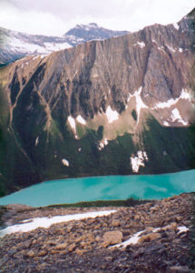
Less than a kilometre before the lake, a small clearing appears, affording you a fantastic view of Mount Ogden bordering the western shore of Sherbrooke Lake. Just beyond the clearing is an extended span of boardwalks raised slightly above the muddy earth. The trail provides a few points of access to the lake as it parallels the eastern shore, and within half an hour you will be at the far end of the lake, climbing up a small section of switchbacks.

Gerry Shea
“Gerry Shea moved to Kamloops from Vancouver at the age of nine, which is when he became enchanted by the nearby hills. It was on a family vacation many years later that he discovered the mountains and began hiking and climbing in his spare time, gathering knowledge and experience that he has since used to help beginning hikers, scramblers and backpackers to trek safely. Gerry lives in Kamloops with his wife and children.”Excerpt From: Gerry Shea. “The Aspiring Hiker’s Guide 2: Mountain Treks in British Columbia.” iBooks.