Distance

The path climbs ever so slightly, levelling off after a moderate gain in elevation. Getting off the Spray River Loop Trail to Mount Rundle is easy, as the trail is well marked right up to its departure to the left. It then begins its slow, monotonous switchback climb through the forest. However, one should enjoy the tranquility of this rocky mountain forest, because before long it opens up to the massive limestone slab that is entirely exposed to the elements. Stay on the main trail, avoiding any minor trail diversions to the left, up the slope. These lead to more technical climbs that are rarely used and are beyond mere scrambling techniques.
About halfway up the trail you will encounter a large drainage ditch that may seem irresistible to climb, but please resist. Although the summit is visible from here, this route is full of impassable rock walls. Cross this gully and stick to the course of the well-marked trail. This climb is one of the most frequented in the National Park system, so holding to the trail is straightforward. You will cross this gully and re-enter the forest, onto steeper switchbacks. Once above treeline the footing beneath you becomes unpredictable, as pebbles cover the smooth, slanted limestone. This is an affirmation that proper footwear with sufficient grip is essential.
Soon you will reach a mental barrier known as the Dragon’s Back. Although no one has fallen from this obstacle, the danger here is quite real, as either side of this narrow strip has nothing to offer except air and rock. After only a few short minutes, you will have conquered the Dragon’s Back, and you will now be faced with an endless, tedious battle with scree and rubble. This truly is the epitome of three steps forward and two steps back. However, don’t despair. My mountaineering friend Peter tells me that climbing scree puts him into a trance-like state and that it is a unique method of meditation. It can be very exhilarating if you want it to be. Whether you reach Enlightenment or not, at least the summit is soon within reach. Keep plodding up this rubble, simply taking it one step at a time and eventually the rocky summit is accomplished. Looking directly across the Spray River Valley (west), you’ll see Sulphur Mountain, with Sanson Peak at the northern edge of this ridge. On a clear day one can see two Rocky Mountain icons off in the distance: Mount Temple is 54.5 km to the northwest, with a true bearing of 295º, and Mount Assiniboine is 33 km to the south, at 200º.
History
This magnificent, unique mountain was named after Rev. Robert Terrill Rundle (1811–1896) in 1858 by John Palliser. Reverend Rundle was a Methodist missionary to the Indians of the Northwest. He was one of four clergy the Hudson’s Bay Company asked to establish missions in their regions. He arrived in Fort Edmonton on October 17, 1840, from England. Rundle was born in Mylor, Cornwall, in 1811 and attended business school in Boscastle in 1837. While in school, he became interested in the Wesleyan Church and was ordained in 1840.
Edmonton became the centre of his territory, allowing him to travel extensively throughout the prairies, the North and into the Rockies. He stayed in Canada for eight years, ultimately returning to England for medical assistance for an injured arm sustained when he fell off his horse in July of 1847. The injury had become persistent due to inadequate medical care and never really healed properly. He left for England in 1848 and never returned.
Rundle travelled with the Indians for years, becoming entranced by both the indigenous peoples and the mountains. He worked so extensively with the Cree, Assiniboine and Métis that he learned to speak Cree, writing hymns for them in their language.
It was James Hector who chose the original name of Terrace Mountain on one of the Palliser expeditions in the area, in 1858. This was short lived, however, as Palliser himself renamed it “Mount Rundle,” also in 1858, because of the extraordinary work Rev. Rundle had performed with the Natives.
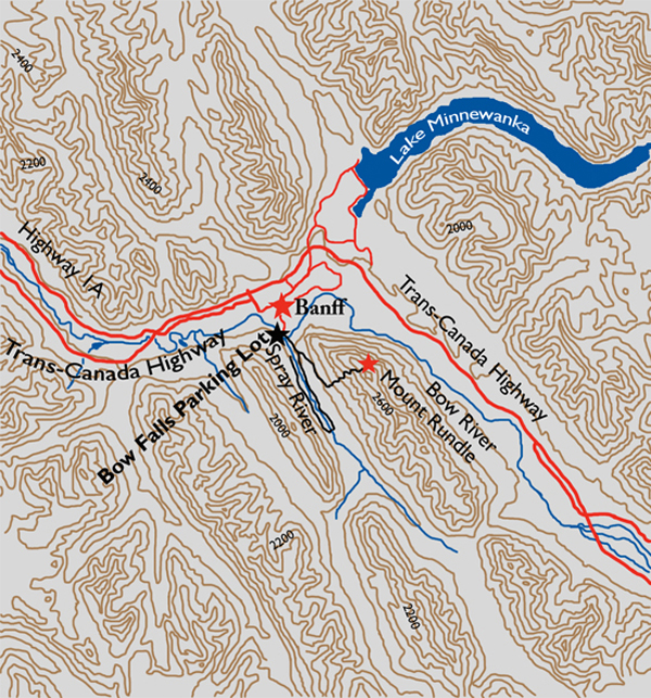
Directions
Parking for the trailhead is at the Bow Falls parking lot. From the Banff townsite drive across the Bow River Bridge at the south end of Banff Avenue. Turn left onto Spray River Road and drive 750 m to Bow Falls Avenue on the left. Turn down here to the Bow Falls parking lot.