Distance

As you level out into Wilcox Pass, the summit of Nigel Peak comes into view to the northeast (right) and the 2-km summit ridge dominates the skyline. There are two possible routes to the summit, with the closest one being a tedious vertical drudge of scree and fist-sized rocks. To get to this obvious scree slope, begin crossing over the wide expanse of Wilcox Pass to the visible perpendicular trail to the left of the main peak. As you come closer to this trail, you will understand why such a short climb can consume so much energy, as there is no break in the straight-up ascent until you arrive at the sub-summit ridge crest. At the top of the crest, a saddle lies between the summit ridge and the true peak.
Stay to the right around the saddle and eventually steer left at a rock headwall to attain the south side of the north ridge to the summit. This is actually quite straightforward once you are up there, but there is some modest amount of exposure, so do not take this lightly.
Every single person has his or her own comfort level with “exposure.” In scrambling and mountaineering, this term refers not to being out in the open and vulnerable to the elements, but to how precarious a ridgetop or ledge or other footing may be, and thus how much danger there is that an incautious hiker or climber could fall a very long way down. These factors, combined with your overall level of exhaustion during a particular climb, determine each person’s comfort zone. When I scramble with my crew, we have a rule that states that if someone does not feel comfortable about a climb, then all of us will turn around and stop for the day, no questions asked. I advise establishing such guidelines before an ascent, to avoid confusion, anger and an undeserved sense of shame during the climb.
The second route is lengthier, but lacks the pain and suffering that a straight-up scree climb has to offer. Instead of cutting directly across Wilcox Pass to the base of the ridge, make a beeline for the much lower, northwest end of the range. At the far end, two well-worn paths venture up to the scree line. Reaching the upper trail is the ultimate goal, and at this spot the trail traverses the scree in a steady incline, making the climb much less intense. Additionally, the elevation gain at this end is far less than the first option, putting you on the summit ridge sooner. The drawback is the extra distance across the pass to the far end of the base of the mountain, as well as the long climb up the 2 km along the summit ridge.
Follow the upper trail up to a small cairn-marked col, and immediately turn right and look over your right shoulder. The sight of a seemingly impenetrable rock wall is somewhat daunting. However, there are three easy ways to overcome this pinnacle by going around to the left, the right or straight up the middle. The most popular route with the least exposure is the path wrapping itself around the left side. Once on top of this obstacle, continue up the summit ridge for a long, spectacular journey toward the summit. The ridge narrows as it progresses to the summit, and your comfort zone may narrow as well. Because of this, you must feel comfortable with the prospect that you may not make the summit and may have to settle for a spectacular ridge walk. Nonetheless, the view from here is still monumental and no less spectacular than the summit. The jaunt here on this route has already delivered great variety and viewing opportunities, and time is just as well spent looking around instead of staring up a scree slope.
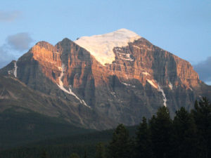
Nigel Peak in the foreground from Mount Wilcox.
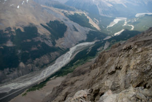
Looking south down Wilcox Pass between Nigel Peak and Mount Wilcox.
History of Mount Wilcox and Nigel Peak
Walter D. Wilcox discovered Wilcox Pass and the neighbouring Mount Wilcox in 1896 but did not name them. Wilcox was an explorer from the US who set out in 1896 to investigate the headwaters of the Saskatchewan River. The pass became the main link between the Saskatchewan and Athabasca rivers. In 1896 there was not much information or exploration of the region north of Bow Pass, as maps were vague and trails were unknown. Therefore, Wilcox took it upon himself to explore this vast uncharted part of the planet with hopes of making important findings. Among them were Wilcox Pass, Mount Athabasca and the Sunwapta Valley. He only narrowly missed the Columbia Icefield. Quite an outing.
In 1898 mountaineering guide Bill Peyto, with his packer and cook Nigel Vavasour, guided Brits Hugh E.M. Stutfield, Dr. J. Norman Collie and Herman Woolley into this pass, which resulted in the discovery of the Columbia Icefield. Collie named the pass and mountain after Walter Wilcox for his efforts in discovering the pass. The wealth of large game in the area was also of tremendous interest to Peyto and his boss, Tom Wilson, as they had many British and American clients with an appetite for big-game hunting.
Vavasour was involved in many hunts, including sheep, during the expedition, exhibiting considerable skill and perseverance. Collie named Nigel Peak in the course of this journey, but it was not until 1919 that it was summited by members of the Interprovincial Boundary Commission.
A student at Yale University, Wilcox had ventured to the shores of Lake Louise in the summer of 1893 and camped out for the summer, since the original, rustic CPR chateau had burned down that same year. During this summer, Wilcox met Samuel Allen and the two began climbing the mountains in the vicinity. They were the first to summit, and hence name, Fairview Mountain, and made unsuccessful attempts on Mounts Victoria and Temple.
They returned the following summer more focused, better prepared and more determined. They also enjoyed better base-camp comfort than the previous year, as upon their arrival a new Chateau Lake Louise was nearing completion, enabling them to obtain lodging, meals, horses and even a boat for $12 a week. The gentlemen made first ascents of Temple and Aberdeen in 1884 and others, including Niblock and Indefatigable, some years later.
Directions
The trailhead is at the parking lot immediately off the highway entering Wilcox Pass Campground and is marked as Wilcox Pass. This parking area is 127 km north of the junction of the Trans-Canada Highway and the Icefields Parkway, on the east side of the Parkway. About 3 km north of this parking lot is the Columbia Icefield Centre.