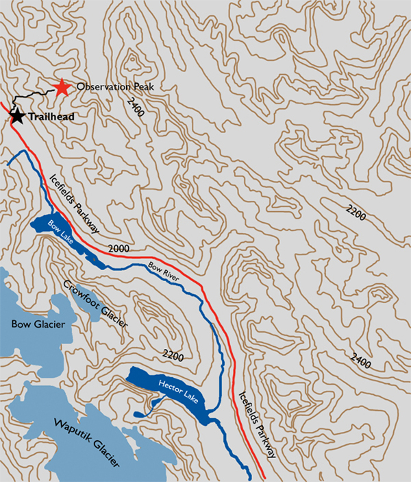
Distance

From the highway walk the old road as it veers left and quickly narrows into a trail. Within five to ten minutes you’ll come to a cairn marking the trail off the road. Step east (right) into the bush and follow the occasionally faint trail through the forest for another 5–10 minutes until it opens up into a drainage gully. Follow the trail on the right side of this gully, keeping an eye on well-placed cairns.
The way is uneventful until halfway up the ridge, where there is a moderate section of scrambling that requires some patience. Again, look for cairns to the right to find the easiest route around this rock band. Otherwise, this minor inconvenience can simply be worked around with little difficulty by climbing over it. Beyond this rock band the trail becomes a scree slope for the remaining 400 m to the false summit. It appears that many earlier scramblers have also had difficulty with this scree slope, as there are numerous trails crisscrossing the slope in an effort to minimize the relentless backward sliding caused by climbing such an incline of rock debris. The easiest way up is to search out the most trampled route and stick to it.
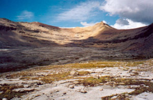
Upon reaching the false summit, take a break from the scree and reap the reward. A sight so beautiful may not come your way ever again. Gaze across the Icefields Parkway to see the incredible turquoise waters of Peyto and Bow lakes. In the background behind these lakes are the toes of the Crowfoot Glacier and the massive Peyto Glacier, which is an extension of the much larger Wapta Icefield. Mount Jimmy Simpson to the southwest and Caldron Peak, behind Peyto Lake, are just two of the noteworthy peaks in full view from the false summit.
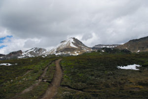
Dipping down into a saddle and ascending up a gentle slope out of the saddle in a northerly direction, the trail takes you to the true summit in 15–20 minutes.
History
After climbing many mountains in this area, Rev. C.L. Noyes and his party realized that this peak offered some of the best panoramas in the area and named Observation Peak in 1899. During an expedition of climbing and exploring the Bow Lake region, Noyes, along with fellow clergyman Rev. Harry P. Nicholls and lawyer Charles S. Thompson, climbed this peak while the two other members of their party, guide Ralph Edwards and another lawyer, George Weed, ventured northward to find a shortcut to the Bow Valley east of present-day Banff. In doing so they discovered Dolomite Pass (see Dolomite Pass History).
The peak is mentioned in Edwards’s book Trail to the Charmed Land as “…an attractive-looking mountain of considerable height to which they had given the name of Observation Peak. This mountain did not seem to present any great difficulty, at any rate to experienced mountaineers such as composed our party…” Both parties returned to camp on a warm July evening to share one another’s stories of a rather adventurous day.
The first ascent of Observation Peak was actually made some years earlier, in 1895, by Bill Peyto and Walter Wilcox, but they left the mountain unnamed. William Peyto was born in Welling, Kent (now London), on February 14, 1869. “Wild Bill” left England to arrive in Halifax in February 1887, and soon found work as a labourer in Golden, BC, with the CPR. He began working with Tom Wilson as a horse outfitter and guide in the Canadian Rockies in 1893. Peyto amassed a modest collection of books, enabling him to educate himself about geology and paleontology.
Walter Dwight Wilcox was one of Bill Peyto’s first clients, hiring him to explore the Bow Lake area and the now nearby Peyto Lake region. Peyto was not fond of climbing mountains, but Wilcox coaxed him into attempting this apparently easy task. After reaching the summit and absorbing the overwhelming scenery, Peyto remarked that he now appreciated the mania for climbing mountains.
Directions
Starting at the interchange of the Trans-Canada Highway and the Icefields Parkway, head north on the Icefields Parkway for 40.5 km to the Bow Summit. Pull over on the east (right) side of the highway onto a gravel road and park.