Distance

As the route gains more elevation, the first mistaken summit is seen directly upward, seemingly within easy reach. Do not be fooled into thinking the summit is as close as this. Once you achieve this rise, there is yet another one to overcome before you reach the actual summit. The trail becomes less trampled, presenting more rubble and shale the higher you climb.
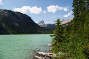
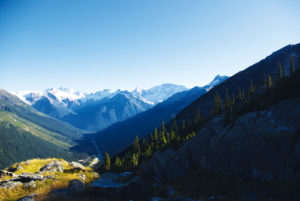
Nearing the top of this exposed, moderately steep slope provides clear views of southern peaks and rivers and most notably the turquoise waters of Sherbrooke Lake to the west. Once at the summit, I’m sure you’ll agree the rewards of this day’s climb far outweigh the effort put in. To the southeast is Mount Victoria, with Mount Lefroy behind it. Just below and to the south are Wapta Lake and the Kicking Horse River.
Paget Peak history
Paget Peak is the only scramble in this guide that features an historic building. Dean Paget, a founding member of the Alpine Club of Canada, recorded the first ascent of this mountain with a group of climbers from the ACC. The fire lookout that bears his name was constructed more than half a century after his summit climb, as a result of two unforgiving fire seasons in the late 1930s and early 1940s. The lookout was in steady use until the late 1970s.
Directions
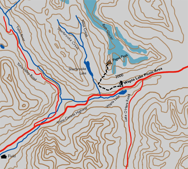
From the pretty little town of Field, drive 11 km east toward Lake Louise to the Wapta Lake picnic area, on the north (left) side of the highway. The signed trailhead is easy to find. If you have a half-hour to spare after your hike, venture into Field and explore the history, meet the locals and enjoy the ice cream.
From the parking lot, head into the forest, and within a few minutes (80 m) you will come to the first marked fork. Turn left and continue up the path in this beautiful subalpine forest for another 1.4 km, then turn left again at the last junction. Another 2.5-km ascent takes you to Paget Lookout. As usual with a hike below treeline, this one consists of switchbacks amid a magnificent forest. Although the trees obscure the view of neighbouring mountains, waterfalls and glaciers, the scenery within the forest is just as rewarding. While walking, focus your senses, listening to the unique sounds and smells that are offered and the display of plant life on the forest floor. Soon you will notice the subtle change in vegetation as the forest thins out to shorter, leaner pine trees. Shortly afterward, you will be more than halfway to the summit, arriving at Paget Lookout.

Gerry Shea
“Gerry Shea moved to Kamloops from Vancouver at the age of nine, which is when he became enchanted by the nearby hills. It was on a family vacation many years later that he discovered the mountains and began hiking and climbing in his spare time, gathering knowledge and experience that he has since used to help beginning hikers, scramblers and backpackers to trek safely. Gerry lives in Kamloops with his wife and children.”Excerpt From: Gerry Shea. “The Aspiring Hiker’s Guide 2: Mountain Treks in British Columbia.” iBooks.