Distance
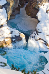
A 1-m-diameter hole in the rock beside the cascade pours with water during spring runoff. The hole was blasted 100 years ago by miners trying to reroute the creek to get at gold nuggets at the falls base. To read about the century of gold mining history of the Perry Creek Falls and area see the introduction.
The deep churning whitewater of spring runoff in late May to mid-June makes the falls especially exciting.
The trail follows along two creeks: Lisbon Creek, with cedar trees and soft mossy carpets along its banks, and Perry Creek, with its round boulders, swift current and wide shallow channel.
The hike to the base of the falls is moderately safe and takes about 45 minutes. The trail is rough and the footing may be unstable in places. There is also a sliding, eroding, gravel hillside to traverse for a short section. Volunteers repair this trail, and with some hand-tool work the trail could be in good shape again.
Do not try to get above the falls for a better view, because the steep loose rock of the canyon folds back just enough to prevent seeing the tumbling water from above the falls. Climbing the slick, steep and loose gravel above the torrential water is extremely dangerous.Trail
0 km: On Perry Creek Road the left fork at a gated road between 7 and 8 km signs is the trailhead. Hike the gated 4x4 road west.
700 m: The trail descends left by a 1950s-vintage abandoned cabin by Lisbon Creek. In some places there is a rope to hold on to while descending the steep track with small round rolling gravels.
1 km: Cross Lisbon Creek on a funky makeshift bridge.
1.3 km: Take the right fork, heading upstream along Perry Creek. The trail winds around an eroding sidehill bank.
1.6 km: Base of the Perry Creek Falls.
Directions
Road: any vehicle
10 km: Perry Creek Falls parking, N89357-E73182 (400 m before 8 km sign). Look for a wide pullout on the right at a junction with a small road just after the bumpy Perry Creek FS road climbs a steep grade and levels off. Park in the pullout. Hike about 200 m west on the main Perry Creek FS road (not the small road heading north). The trail begins on the left on a small gated road (the only left fork between 7 and 8 km signs).

Janice Strong
Janice Strong is an established professional outdoor photographer. Her images grace collections all over the world and appear in many respected publications. She is passionate about hiking and is also an avid snowshoer and skier, exploring the outdoors of the East Kootenay in southeastern BC year round.She openly shares her passion for the outdoors with others and has introduced hundreds of people to the joys of hiking. For a decade she led hikes for the City of Cranbrook – Parks and Recreation. With her guidance, many people have themselves become enthusiastic hikers.
Climbing mountains, finding new places and enjoying the experience of the journey have always been important to Janice. She cherishes the little things she sees along the trail, as well as the grand destinations.
When Janice is not writing, hiking or taking photographs, she is involved in various creative digital, website design or photographic projects for her clients. She and her husband, Jamie Levine, enjoy their rural property, near Cranbrook, BC.


