Distance
This easy, low-elevation place, with pleasant scenery and dry open slopes dotted with wildflowers, seemed almost too good to be true.
As we hiked, old snags vibrated with a loud drumming echo as woodpeckers beat on the deadwood for food. Squirrels scolded us from treetops as they dropped cones nearby. The clumsy-looking winged carpenter ants were out looking for more colony homes. Wood ticks were also abundant, but we found short sleeves and loose pants far too comfortable to allow a few thirsty ticks to stop us from sunning our winter-pale skin.
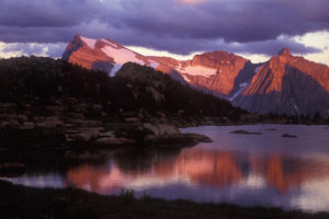
The hike to Premier Ridge with a side trip to the overview of Quartz Lake is a good long-day outing. Premier Ridge stretches between Wasa Lake and Premier Lake. The views from this low-elevation ridge offer a 360-degree panorama, the best views I know of from a low elevation. The majestic snowcapped Rocky Mountains rise to the east and the ripple of the Purcell Mountains follows the western horizon. The Kootenay River winds along the bottom of the Trench and Speculation Lake nestles in the forest just west of Premier Ridge.
Spring is the best time to walk on the grassy open slopes of Premier Ridge, when flowers are blooming, the ground is dry and the air is warm. Premier Ridge is a hot and dry bulge of land. The ridge is several kilometres long in the bottom of the deep, U-shaped Rocky Mountain Trench, with the mountains rising 1500 m (5,000 ft.) along both sides. At certain times of the year, the Rocky Mountain Trench can act like a massive, parabolic, solar collector, concentrating the sun’s energy toward its centre. Premier Ridge can get very hot.
Hike Wasa (Wolf Creek Rd) to Premier Ridge
0 km: Start hiking from the parking spot in the meadow by Wolf Creek Road, at 914 m (3,000 ft.), N22600-E96900. Follow the road for only a few hundred metres north into the forest. The route along Premier Ridge does not follow a trail. Hike generally north and follow the long, wide, sloping ridge. As you routefind north, take a variety of overgrown trails, old and new roads and animal paths. Walk on grassy slopes, rocky slopes, through ponderosa pine and Douglas fir forests and across sunny meadows. Gradually work your way north and uphill, spotting the ridgeline from the grassy meadows.
5 km: Approximate length will depend on your wanderings, but it’s about 7 km following the roads and trails. In the last 500 m or so before you climb to the summit of Premier Ridge, N27500-E96400, cross a sagging fence and find a well-defined trail heading north steeply up the forested rocky knoll. This part of the hike is ambiguous, but if you find the fence, you should be able to locate the trail to the summit. Otherwise it is a steep bushwhack, about 10 to 15 minutes of steep hiking.
5.5 km: The summit, N27745-E96338, at 1344 m (4,410 ft.). Hike back down to the fence and just south of the fence look for the remnant of defined road heading downhill east.
6.5 km: Follow the old road, descending about 200 m (650 ft.), and it will intersect with the Wasa/Premier vehicle road, N29489-E97143. For a view of the Quartz Lake overlook, turn right on the vehicle road and hike about 400–500 m to a scuffed and well-visited meadow with the Quartz Lake overlook on the left (east) side. From this flat meadow the cliffs drop almost 150 m (500 ft.) straight down into the jade-coloured deep water of Quartz Lake, and the Rocky Mountains rise just east, a rewarding sight. After the overlook the road continues south. Stay on this dry road for 5.6 km to complete the loop. It is downhill most of the way.
12 km: The road joins back to the meadow where you parked your vehicle.
Hike or Bike from Premier Lake
The hike to Premier Ridge from Premier Lake is shorter than from Wasa, but not nearly as scenic, plus the hike is in the forest the whole way and you miss the open, grassy, sunny slopes that make the hike to Premier Ridge a nice day outing.
0 km: Begin hiking or cycling from the day-use parking lot in Premier Lake Provincial Park by the overflow campground. Hike back up the main road for 220 m. Take the first small gravel road on the left (south). This gravel road immediately branches; take the right fork to the overlook and Premier Ridge (the left fork leads to the shore of Quartz Lake and boat access, 2.2 km).
Posted a short distance from this junction is a road map sign for “Premier Ridge Area Road Closure.” Read more about Ministry of the Environment/Wildlife Branch wildlife closures in the introduction. In summer you can drive these roads, but they are high-clearance and rough. Check the dates posted on the vehicle closure signs.
Hike, bike or drive the road. It is moderately steep and rocky and it climbs 195 m (640 ft.) in shady Douglas fir forest. The track finally levels off at a cattle guard at 1090 m (3,600 ft.) elevation.
4.4 km: Stash and lock your bike by the cattle guard, N29489-E97143, to continue the hike to Premier Ridge. Quartz Lake overlook is another 400–500 m south of the cattle guard. See the overlook description above. Hike or bike back to the cattle guard.
4.5 km: Just south of the cattle guard, look for a faint old road heading uphill (west). The summit of Premier Ridge is 1 km up this steep road that gains another 200 m (650 ft.). When the road fades out in a level spot in the forest, there is a sagging fence, N27500-E96400.
5.5 km: (Approximately.) The summit of Premier Ridge, N27500-E96400.
Directions
Road: any vehicle
0 km: Highway 93/95 at Wasa. Turn east Wasa Lake Park Drive (north access). This road circles Wasa Lake and connects back to the highway.
0.9 km: Left turn (north) onto Wolf Creek Road.
6.1 km: Stay on Wolf Creek Road as it bends east.
14 km: Park in a large meadow on the north side of the road. The meadow is a couple hundred metres before Wolf Creek Road turns right at a sharp downhill, N22600-E96900.
A small gravel road heads north from the the meadow. A sign indicates the dates of motorized vehicle closures, May 1 to Nov 30 as part of a Wildlife Management Access Area, go to the introduction for more on area closures.

Janice Strong
Janice Strong is an established professional outdoor photographer. Her images grace collections all over the world and appear in many respected publications. She is passionate about hiking and is also an avid snowshoer and skier, exploring the outdoors of the East Kootenay in southeastern BC year round.She openly shares her passion for the outdoors with others and has introduced hundreds of people to the joys of hiking. For a decade she led hikes for the City of Cranbrook – Parks and Recreation. With her guidance, many people have themselves become enthusiastic hikers.
Climbing mountains, finding new places and enjoying the experience of the journey have always been important to Janice. She cherishes the little things she sees along the trail, as well as the grand destinations.
When Janice is not writing, hiking or taking photographs, she is involved in various creative digital, website design or photographic projects for her clients. She and her husband, Jamie Levine, enjoy their rural property, near Cranbrook, BC.


